Geotimes

Feature
The Many Faces of the Alamo Impact Breccia
John E. Warme
 About 370
million years ago, an object from space splashed down into the Devonian sea
that bordered western North America, almost instantly blanketing much of southern
Nevada and surrounding areas. Now known as the Alamo impact, the event resulted
in one of the best-exposed and well-dated impact deposits and a full-scale physical
model for understanding wet impacts: the Alamo Breccia.
About 370
million years ago, an object from space splashed down into the Devonian sea
that bordered western North America, almost instantly blanketing much of southern
Nevada and surrounding areas. Now known as the Alamo impact, the event resulted
in one of the best-exposed and well-dated impact deposits and a full-scale physical
model for understanding wet impacts: the Alamo Breccia.
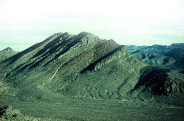
View of 1,000 meters of Devonian shallow-water limestones in the Western Pahranagat
Range of Nevada. The Alamo Breccia is the thickest resistant interval within
the lower part of the Guilmette Formation, exposed on the steep western flank
of the range. The breccia formed during a catastrophic impact event about 370
million years ago. All images courtesy of John Warme.
This exceptional interval of broken, angular fragments of sedimentary rock (breccia)
exceeds 100 meters in thickness at some localities, where it contains dislocated
blocks hundreds of meters long and tens of meters high, and ranges down to only
a few meters or less over a wide area. We have discovered outcrops of the breccia
from Frenchman Mountain near Las Vegas northward for about 350 kilometers into
central Nevada and possibly Utah, exposed in about 25 different ranges. It covers
a minimum of about 100,000 square kilometers. If the breccia averages a conservative
10 meters in thickness over its entire area, the total rock volume moved during
the Alamo event is 1,000 cubic kilometers.
The Alamo impact fractured and excavated the Devonian fossil-rich limestone
shelf that formed a broad platform along the western edge of the continent.
Ensuing tsunamis rearranged much of the debris. The impact also triggered voluminous
underwater landslides that coursed as debris flows and turbidity currents into
the Devonian ocean in western Nevada. The resulting Alamo Breccia thus presents
many faces, or “facies” in stratigraphers’ terms. Each facies
indicates the kind, location and timing of processes encompassing the rapidly
moving events that created the Alamo Breccia.
Discovery
Nevada is full of thick limestone formations and thus full of carbonate rock
breccias. They represent original sedimentary breccias, such as rock broken
along faults, in mineralized zones or as cave fillings. Academic, government
and exploration geologists had seen outcrops of the Alamo Breccia, but mistook
it for other kinds of breccias. The discovery of the unique nature of the Alamo
Breccia was by accident.
During field reconnaissance at Tempiute Mountain in January 1990, a gravelly
limestone breccia caught the attention of then Colorado School of Mines (CSM)
graduate student Alan Chamberlain and UNOCAL petroleum geologist Norman Kent.
They showed me a sample, and we were all puzzled because the breccia was atypical
of the Upper Devonian Guilmette Formation in which it occurred. Two days later,
we noticed another outcrop of equivalent age at Mount Irish, about 30 kilometers
eastward. There, we saw much larger breccia fragments, or “clasts,”
several meters across.
Our discovery team was fortuitously preadapted to quickly piece together this
unique stratigraphic unit: Our team included geologists and paleontologists
who intimately knew the Nevada rock formations. For example, I had experience
studying ancient shallow-water limestones on modern tropical islands and in
formations of various ages in North America, North Africa and Europe, and initially
recognized that this breccia was truly anomalous and deserved investigation.
Once we were aware of the nature of the breccia, we knew what to look for and
where to search within the vast and complicated geological landscape of Nevada.
Also, the possibility that the breccia was triggered by an impact was in our
consciousness, owing to the excitement and controversy generated around a report
10 years earlier that a huge impact had altered the world’s environment
and could be responsible for the Cretaceous/Tertiary extinctions. The age had
dawned when the geological community was more willing to accept that many more
impact craters and their debris could be identified. Researchers could confirm
candidate fossil impacts using new tests, tools and observations.
More field trips to Nevada included CSM graduate students Brian Ackman, Jane
Estes and Yarmanto. Our team found the same kind of deposit in several ranges
around the settlement of Alamo, 150 kilometers north of Las Vegas. It occupied
the same stratigraphic position in the Guilmette, but showed variations in thickness,
clast size and fossil content. Over the next few years, we continued to piece
together its systematic vertical and lateral properties. I named it the Alamo
Breccia, which I thought was catastrophically fitting, and in 1997, it was formalized
as the Alamo Breccia Member of the Guilmette.
Our early reports of the Alamo Breccia as a single widespread deposit were met
with doubt; and many researchers, especially those with experience in our Nevada
field area, were skeptical regarding the breccia as a potential impact phenomenon.
We organized a weeklong field workshop in May 1991 and invited Nevada stratigraphers,
paleontologists, structural geologists and impact experts. By the end, most
participants agreed that they had surveyed an anomalous catastrophic sedimentary
megabreccia that was not derived from tectonics, solution collapse or other
processes. As for a crater, Walter Alvarez from University of California, Berkeley,
sampled sandstones under the breccia at Tempiute Mountain, but failed to find
telltale shocked quartz. At that time we could not identify a crater.
Smoking
arsenal
We sought an energy source that could explain the spread of an anomalous catastrophic
breccia across a shallow marine shelf: The search was on for a “smoking
gun.” We considered large-scale crustal tilting, earthquakes, volcanic
explosions, storms, tsunamis and impacts. In the absence of an obvious crater,
impact proxies could include shocked quartz or other shocked mineral grains,
iridium anomalies, impact ejecta and tsunami deposits. The breccia provided
an arsenal of such clues.
The first breakthrough was when Ackman discovered a rare quartz grain in a breccia
thin section. The grain showed three directions of shock lamellae (sets of numerous
fine parallel fractures created by impact shock waves); however, they were poorly
developed and unconvincing to the shock-mineral experts we consulted. Thousands
of shocked grains were subsequently recovered from insoluble acid residues,
containing as many as six directions of lamellae planes and confirmed by transmission
electron microscope studies.
We were disappointed when low iridium values were reported from three different
labs. The maximum was 139 parts per trillion compared to thousands of parts
per billion at the Cretaceous/Tertiary boundary. Then we realized that most
of each sample sent for testing was locally derived Devonian rock that greatly
diluted any space-borne components incorporated into the breccia.
By far the most significant newly found indicators within the breccia are spherical
lapilli (2 to 6 millimeters in diameter) and larger bombs that formed ballistically
in the impact cloud during the Alamo event. They imitate lapilli and lava bombs
from silicate volcanoes, but are made of limestone and share some properties
with the carbonate lapilli described from the Chicxulub ejecta around the Yucatan
Peninsula. They even contain fossil fragments and rare tiny shocked-quartz grains.
The lapilli were formed from pulverized target limestone that was heated and
dehydrated while launched from the crater. In the wet impact cloud, the dust
accreted around nuclear fragments and began to rehydrate and harden. The lapilli
precipitated as a blanket, which continued to harden as a bed outside the target
zone until it was smashed apart by powerful tsunamis. We find fragments of the
lapilli bed only as rare, isolated clasts squashed among the rest of the debris
in the upper half of the breccia.
The middle of the Late Devonian contains one of the largest levels of fossil
extinctions. We thought that we had the cause: a large impact in Nevada. Paleontologist
Charles Sandberg of the U.S. Geological Survey joined the project and confirmed
that the breccia was deposited within a single fossil zone that represented
less than 1 million years of Late Devonian time. Unfortunately, it was about
3 million years too early and classed as “sub-critical” as a potential
extinction event.
We recognized that the breccia rested in three zones based on its thickness.
Sandberg and colleague Jared Morrow of the University of Northern Colorado in
Greely discovered the breccia beyond the zones in the deeper-water basin to
the west.
Hans-Christian Kuehner, a CSM doctoral student, carefully documented details
of the breccia at several localities. His results led us to realize that the
breccia was internally complicated. Kuehner provided a new model against which
we continue to test our ideas. Then Chamberlain finished mapping in southern
Nevada and proposed that the distribution of the breccia was compressed and
skewed by post-Devonian west-to-east thrust faults across the study area. Tectonic
shortening could account for abrupt changes in the character of the Alamo Breccia
between closely spaced outcrops, for the semicircular pattern of the zones,
and for the rapid change from shelf to offshore. Chamberlain’s concept
is still being tested in the field.
Scenarios
Three scenarios have been proposed in print to explain the distribution of
Alamo Breccia facies. In 1996, Sandberg and I offered our hypothesis that a
seaward-flowing slide, triggered by an impact and modified by a tsunami, left
the three zones of breccia on the shelf and sent massive flows into deep water
offshore. Because some of the fossils in the breccia were typical of deeper
marine environments, we surmised that the impact was offshore and somehow transported
the fossils and other debris landward.
In 1998, Morrow and others also proposed that the impact occurred on the slope
or in the basin offshore, though no crater-bearing outcrops exist to directly
test that proposal.
In 1998, Kuehner and I learned of a comprehensive model for a marine impact
published by Verne Oberbeck and his NASA colleagues. We applied their model
for shelf-marine impacts, based on studies of natural terrestrial and extraterrestrial
craters, nuclear and other explosion craters, laboratory impact experiments,
and cratering theory. NASA scientists Fred Hörz, Dave Roddy, Ted Bunch
and Oberbeck joined us at various times in the field and helped us refine both
our observations and our thinking about the genesis of the breccia. We found
new, more far-flung breccia localities, and realized that many different kinds
of breccias were created by the Alamo event that could be compared with the
model (see sidebar).
Work ahead
In 2001, I persuaded Christian Koeberl (University of Vienna), Philippe Claeys
(Vrije Universiteit, Brussels) and Alvarez to join me in convening a Geological
Society of America Field Forum, “Bolide Impacts on Wet Targets,” with
40 invited experts. We used the Alamo Breccia and Upheaval Dome in Utah as field
cases. Questions for the Alamo segment included the reason for its apparent
lopsided distribution and the location of the crater.
The major conclusion was that more fieldwork was required and the structural
problems needed to be resolved in order to model the Alamo event. Modeling could
constrain the size of the impactor and the size, water depth and location of
the crater, but the original distribution and thickness of the breccia were
required data. We continue to pursue that structural reconstruction.
Western exposures of the Alamo Breccia are threaded by Nevada’s Extraterrestrial
Highway and lie just north of forbidden Area 51, where the U.S. Department of
Defense conducts secret tests. Area 51 unfortunately may encompass outcrops
vital to our quest for the crater.
Nevertheless, the certain flux of impacts throughout geologic time assure that
many more overlooked impact deposits will be discovered in the global stratigraphic
record. We must be alert for catastrophic signatures, be aware of new paradigms,
and match our imaginations to the scale of these events.
Sidebar
Mapping the
breccia
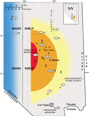 Researchers
have mapped the Alamo Breccia, an impact deposit created about 370 million
years ago, into an area covering three zones and a deeper western basin. Researchers
have mapped the Alamo Breccia, an impact deposit created about 370 million
years ago, into an area covering three zones and a deeper western basin.
Map of the extent of the Alamo impact (for a higher-resolution version,
click
here).
Numbers on the map at left and lower cross section below indicate the
position of nine different types of breccias created by the Alamo impact
event. Four of these are different kinds of seismites, created by impact
energy transmitted through bedrock. The cross sections apply Verne Oberbeck
and colleagues’ 1998 shallow marine impact model to the Alamo Breccia.
Zone 1: Breccia types 1 and 2 are interpreted as seismites that
formed under the crater. Type 1 is a sandstone-filled dike-and-sill system
injected into a dolomite formation 300 meters under the Alamo Breccia.
Type 2 is a distinctive system of fractures and fluid transfer within
the dolomite. Type 3 is breccia that eventually flowed into the newly
formed crater.
Zone 2: Early shock waves propagated through the shelf limestone,
leaving vertical fractures and a thin interval of sub-horizontal fluidized
rock (seismite, type 4 breccia) 50 to 100 meters below the surface. This
weakened interval and the fractures shaped megablocks hundreds of meters
long, which laterally oscillated from subsequent seismic waves and partially
self-destructed. The result is a train of discontinuous megablocks, some
with spectacularly folded ends, separated by broken rock of all sizes.
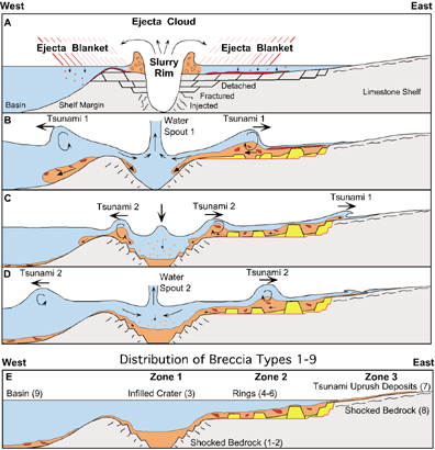 Meanwhile,
the impact ejecta curtain spread outward at initial speeds that easily
exceeded Mach 1, pummeled the shelf and mixed with preexisting shelf limestone
to form chaotic type 5 breccia. Lapilli accreted in flight, blanketed
large areas, and began to harden into a bed. A transient crater and slurry
rim of water and debris formed, which then collapsed outward to create
tsunami 1 and inward to form waterspout 1. Tsunami 1 propagated across
zone 2 and reworked ejecta and newly broken rock. Waterspout 1 collapsed
to create tsunami 2. Backwash of tsunami 1 formed a second waterspout
that collapsed. As many as five such cycles occurred and damped out, leaving
as many as five stacked, progressively thinning-upward and graded tsunamites
(type 6). During violent reworking of the shelf, the lapilli bed was dismembered
and scattered among other clasts. Tsunami backwash filled the crater cavity
with well-sorted debris in zone 1 (type 3). Meanwhile,
the impact ejecta curtain spread outward at initial speeds that easily
exceeded Mach 1, pummeled the shelf and mixed with preexisting shelf limestone
to form chaotic type 5 breccia. Lapilli accreted in flight, blanketed
large areas, and began to harden into a bed. A transient crater and slurry
rim of water and debris formed, which then collapsed outward to create
tsunami 1 and inward to form waterspout 1. Tsunami 1 propagated across
zone 2 and reworked ejecta and newly broken rock. Waterspout 1 collapsed
to create tsunami 2. Backwash of tsunami 1 formed a second waterspout
that collapsed. As many as five such cycles occurred and damped out, leaving
as many as five stacked, progressively thinning-upward and graded tsunamites
(type 6). During violent reworking of the shelf, the lapilli bed was dismembered
and scattered among other clasts. Tsunami backwash filled the crater cavity
with well-sorted debris in zone 1 (type 3).
Zone 3: The most powerful tsunami left a thin, graded bed typical
of zone 3 (type 7). Seismic waves fractured the shelf and formed distinctive
seismites (type 8) as far as Frenchman Mountain near Las Vegas.
Cratering processes and shelf-rim collapse shed large volumes of debris,
creating the variety of deepwater breccias (type 9) still being found
in offshore formations.
Although this working scenario explains the distribution of the types
of Alamo Breccia, problems remain with respect to the original paleogeographic
configuration of the shelf, slope and basin, and the crucial question
of the location of the crater.
JEW
|
Warme is professor emeritus
at the Colorado School of Mines in Golden. He enjoys using fossils and sedimentology
to interpret sedimentary rocks and especially to solve anomalous stratigraphic
puzzles by invoking and testing possible catastrophic causes. Current work includes
sub-Recent landslides in the Grand Canyon of Arizona, Jurassic shelf-edge slides
in Morocco and continued work on the Devonian Alamo Breccia.
Further reading:
Alvarez, W., 1997, T. rex and the Crater of Doom.
Princeton, N. J., Princeton University Press, 185 p.
French, B. M., 1998, Traces of Catastrophy,
LPI Contribution No. 954. Houston, Lunar and Planetary Institute, 120 p.
Laroux, H. Warme, J. E., and Doukhan, J. E.,
1995, "Shocked quartz in the Alamo breccia, southern Nevada: Evidence for
a Devonian impact event," Geology, v. 25, p. 1003-1006.
McGhee, G. R. Jr., 1996, The Late Devonian
Mass Extinction. New York, Columbia University Press, 303 p.
Morrow, J. R., Sandberg, C. A., Warme, J. E.,
and Kuehner, H.-C., 1998, "Regional and possible global effects of sub-critical
Late Devonian Alamo impact event, southern Nevada, USA," Journal of
the British Planetary Society, v. 51, p. 451-460.
Oberbeck, V. R., Marshall, J. R. and Aggarwal,
H., 1993, "Impacts, tillites, and the breakup of Gondwanaland," Journal
of Geology, v. 101, p. 1-19.
Warme, J. E., 2001, "Field Forum Report,
Bolide Impacts on Wet Targets," GSA Today, v.11, p. 30-31.
Warme, J. E., and Kuehner, H.-C., 1998, "Anatomy
of an Anomaly: the Devonian catastrophic Alamo impact breccia of southern Nevada,"
International Geological Review, v. 40, p. 189-216.
Warme, J. E., Morgan, M., and Kuehner, H.-C.,
2002, Impact generated carbonate accretionary lapilli in the Late Devonian
Alamo Breccia. Geological Society of America Special Paper 356, p. 489-504.
Warme and Sandberg, 1996, "Alamo megabreccia:
record of Late Devonian impact in southern Nevada," GSA Today, v.
6, p. 1-7.
Back to top
