|
 Subscribe

Geophenomena
National park awash with costly destruction
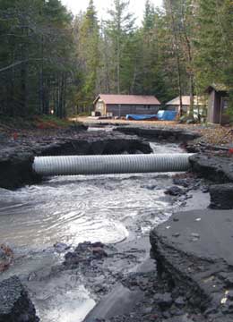
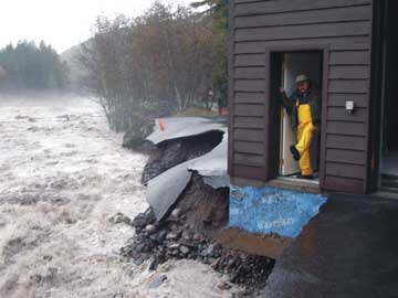
Rain, not lava, was the culprit in the slew of damage to Mount Rainier National Park Nov. 6 and 7 in Washington state. Over 36 hours, more than 45 centimeters (18 inches) of rain caused rivers to flood to levels that undercut roads, washed away campgrounds and triggered landslides.
The Pineapple Express — a jet stream that carries warm, wet air from Hawaii across the Pacific Ocean and to the West Coast — is blamed for dumping the record-breaking amount of rain on Washington and Oregon. The storm resulted in the deaths of three people, according to a Nov. 8 Associated Press story.
Lee Taylor, a spokesperson for Mount Rainier National Park, said on Nov. 21 that the park is slowly cleaning up. The road along Cowlitz Creek is “looking a lot better,” she said, as crews have cleared debris and diverted water from flowing over the road. Still, much work remains: Five roads, four campgrounds, one amphitheater, three buildings and numerous trails across the park were damaged by the flooding.
Rep. Norm Dicks (D-Wash.) toured the park Nov. 21 to view some of the damage, which, as of early December, had already cost the park more than $700,000. Dicks “expressed his commitment to the park,” to see that the interior appropriations committee helps the park get more funding to help with recovery efforts, Taylor said. The incident management team at the park “will be hopefully making rapid decisions to help quick progress on recovery from the flood so we can get ready for winter operations — hopefully,” she added. As of Dec. 5, roads remained closed, although some regions were open for non-motorized recreation, according to the park’s Web site.
1. The road to the Kautz Helibase was washed out and is not passable. |
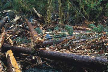
2. A 1,520-meter-long slide ended here, at Ohanapecosh campground, destroying several campsites and part of the road. A blue picnic bench in the center of the photo shows the scale of the incident. |
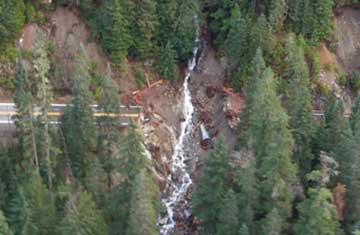
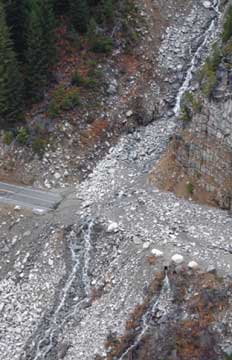
3. This dramatic aerial photo shows a channel, about 18 meters wide and 24 meters deep, that cut across Highway 123. Almost a kilometer down the road a debris flow washed out the road. |
4. The same large landslide that took out part of Ohanapecosh campground also wiped out Stevens Canyon Road in two places, including the location seen here. |
5. The parking lot in front of the Emergency Operations Center at Longmire was destroyed when it was undercut by the rising Nisqually River. A corner of the building was also damaged, as was about 60 meters of sewer line that was emptying into the river. |