
 Heavy rains in
June inundated the lagoon city of Venice and aided tides in setting record flooding
levels for that time of year. Rarely have summer tourists waded though the iconic
flood waters in Saint Mark's Square as they did on June 6, when the water reached
121 centimeters above average sea level.
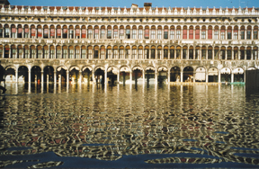
Heavy rains in
June inundated the lagoon city of Venice and aided tides in setting record flooding
levels for that time of year. Rarely have summer tourists waded though the iconic
flood waters in Saint Mark's Square as they did on June 6, when the water reached
121 centimeters above average sea level. The lowest point in Venice, St. Mark’s Square begins to flood when the tide reaches 70 centimeters above sea level. Photo courtesy of Miroslav Gacic
As the lowest point in the city, the square begins to flood when tides reach 70 centimeters above average sea level. Since the 1950s the number of floods above 80 centimeters has increased from about 20 a year to about 50 a year. The largest flood to hit Venice occurred in November 1966 after a great storm diverted the Sile River into the lagoon and raised tidal flooding to a record 194 centimeters. The winter high tides make November and December the worst months for flooding.
As sea level is expected to rise over the next 100 years, high tides are anticipated to push stormwater floods to record levels with more frequency. In order to protect the city from the onslaught of the Adriatic Sea, the Italian government decided last December to move forward on a $2.6 billion dollar project to construct a series of mobile gates at the three inlets into the Venetian Lagoon over the next eight years.
In the May 14 issue of Eos, Transactions of the American Geophysical Union, scientists debated the soundness of the mobile gate plan, called MOSE for Experimental Electromechanical Module, and its long-term capabilities.
The 79 gates are currently designed to rise from a resting position at the bottom of the lagoon to an angle that would protect the inlets from the lapping sea only during periods of threatening high tide. Compressed air would be injected into the hollow gates when tides brought water levels 110 centimeters above normal. Critics of the project are concerned that the protection the gates provide may in turn hamper navigation and cause potential environmental impacts to the natural flushing of the lagoon if sea-level rise forces them to close often.
With frequent closures, "there is a danger that the lagoon will not be ventilated enough," says Miroslav Gacic of the National Institute of Oceanography and Experimental Geophyiscs in Trieste, Italy. To address this concern, Gacic and colleagues are conducting a two-year study measuring the tidal exchange through the three inlets where the gates will be built. They reported preliminary results from last summer showing that the entire 550 million cubic meters of the lagoon is flushed in a single day, primarily through tides. Even infrequent openings of the gates, of only a few hours a day, might dispose most of the collected waste water out to sea, Gacic says. Still he adds, "other measures have to be taken together with construction of the gates, such as prevention of the lagoon pollution by industrial and city waste waters."
But Paolo Pirazzoli of the French Centre National de la Recherche Scientifique contends that, "apart from the degree of water pollution in the lagoon, the main concern is the duration of closures, because the gates, as projected, are not watertight." While the barrier will allow water to move between individual gates, Pirazzoli's concern is with the oscillation of the individual gates as they move with the waves and the gaps that oscillation might create when neighboring gates are out of phase. In the same issue of Eos, he argues that other techniques such as raising street-level elevations and increasing water resistance at the inlets by decreasing water depth would "return the frequency of flooding to the very acceptable level of about one century ago." He says such techniques would provide "a few decades," giving scientists time to better estimate sea-level rise and design a more effective, watertight barrier between the lagoon and the sea.
The final design of the gate plan, however, is still under consideration. And Rafael Bras of the Massachusetts Institute of Technology says that the redesign of the gates makes the walls thicker, preventing any gaps from occurring when the gates move out of phase under the waves. "Water tightness is not an issue," he says. Bras and colleagues at MIT and the University of Padova, Italy, wrote in the same Eos issue a response to Pirazzoli. "The issue in the face of the worst-case scenario of a 50-centimeter rise in the next 100 years is that the barriers would have to be closed very often. This would have a significant impact on navigation to the Port of Venice unless a large ship lock is built at Malamocco, and this is being considered for the final design."
Christina Reed
back to top
