
Most of the ocean shorelines of North America are retreating and putting at
risk an increasingly large number of buildings that line their beaches. Construction
of seawalls used to be the primary response to this problem, but with widespread
recognition that beaches disappear in front of static structures, this response
has been used less frequently in recent years. Six states have even outlawed
seawalls, although in each case, the laws have been compromised in the political
system.
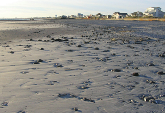
Mud balls are scattered across the surface of the beach along Atlantic Beach,
N.C., after a nourishment project. Besides leaving mud behind, the excess mud
probably damages near-shore organisms. Courtesy of Frank Tursi, North Carolina
Coastal Federation.
If a seawall is not constructed, then the remaining alternative responses are
either moving back or demolishing buildings, or pumping new sand onto the beach.
The latter process, euphemistically called beach nourishment, has come to the
fore in recent decades.
Nourishment has been carried out on beaches on both sides of the continent,
but by far the greatest effort in dollars and sand volume has been expended
on the East Coast barrier islands between the southern shore of Long Island,
N.Y., and southern Florida. Over this shoreline reach, communities have added
a total of 500 million cubic yards of sand on 195 beaches in 680 separate instances.
Some beaches, such as Wrightsville and Carolina beaches in North Carolina, have
been renourished more than 20 times each since 1965. Virginia Beach has been
renourished more than 50 times. Nourished beaches typically cost between $2
million and $10 million per mile.
In 2001, the nation’s first artificial beach to be officially funded as
a turtle habitat restoration project was pumped up along 2 miles of Oak Island,
N.C. It was a rather extraordinary $11.5 million tax-paid expenditure for a
beach that normally has 12 turtle nests a year. Unfortunately, the sediment
pumped onto the beach contained abundant fist-sized and larger limestone cobbles,
making the beach hazardous for turtles and humans alike. The sediment came from
a “spoil” pile of previously dredged material from the intracoastal
waterway behind the island.
In 2003, the material pumped up on Emerald Isle, N.C., and on Jacksonville Beach,
Fla., consisted largely of shell hash (shell gravel), impossible to walk on
barefooted. In both cases, the material probably came from relict lagoon deposits,
with abundant oyster shells, stranded on the inner continental shelf.
On Atlantic Beach, N.C., in 2005, the sediment pumped was probably more than
30 percent mud. It was derived from a pile of dredge spoil from the Morehead
City harbor in North Carolina.
For each of these failed artificial beaches, geologists or engineers with the
U.S. Army Corps of Engineers or who were consulting for the local communities
sampled the mining sites and should easily have detected the problem. The fact
that these parameters were not taken into account may be a measure of the huge
intrusion of politics into the geology of beach nourishment.
Underestimation of such beaches’ lifespans and costs are routine because
an optimistic estimate is helpful in obtaining a favorable cost-benefit ratio
for Congress. The challenge for geologists is to predict the rate of loss of
a nourished beach, a process that is largely dependant upon randomly occurring
storms of variable intensity, direction and duration. Once dredging of sand
begins, it is nearly impossible to halt a project even if the sand is unsatisfactory.
The start-up costs of a dredging project, even before a single grain of sand
is moved, are high, often on the order of a million dollars, and no one wants
to lose such an investment.
Another challenge for geologists is to find large volumes of sand of the correct
grain size at a location where the environmental impacts of mining will be minimal.
It is not an easy task.
Correct grain size is defined as a similar size to the native beach sand. Sand
that is coarser than native sand will provide a steeper beach (much appreciated
by surfers), while a finer grained flat beach will find favor with families.
Reefs, hardgrounds (rock outcrops) and commercial and recreational fishing zones
are particularly vulnerable to damage from dredging.
Artificial beaches usually disappear at much faster rates than natural beaches.
As a consequence, nourishment must be carried out repeatedly at intervals that
depend on storm frequency and a number of other factors. Most must be renourished
at intervals between three and nine years. The planned 14-mile-long nourished
beach on North Carolina’s Outer Banks (for which the predicted 50-year
cost is $1.6 billion) is expected (by the Army Corps) to erode at five times
the rate of the natural beach, and must be renourished every three years. Even
this estimate of a short beach lifespan is likely to be optimistic for the high-wave
energy environment of the Outer Banks.
Potential sand sources include lagoons, tidal deltas at inlets and the continental
shelf. Rarely is sand obtained from lagoons because of threats to shellfish
and crabs and because the damage is visible. If a proposed offshore mining site
is too close to the beach, the depression left behind by the mining could cause
wave refraction and enhance erosion of the nourished beach.
To prevent this and to minimize environmental damage, the Dutch, for example,
require over-the-horizon mining on the shelf at a minimum water depth of 20
meters, several kilometers offshore. In contrast, the mining site for the shell-hash
project on Emerald Isle was a mere 500 meters offshore!
Generally speaking, the best quality sand is that composing tidal deltas at
barrier island inlets. This is actually beach sand that is carried to the inlet
by longshore currents. However, natural (unjettied and undredged) tidal deltas
are unsuitable sites for mining because they are in equilibrium with tides,
wave conditions and sand supply. When sand is removed, the tidal deltas reconstitute
themselves and in the process, deprive adjacent beaches of sand, leading to
their erosion. Mining the tidal delta at Shallotte Inlet, N.C., for example,
led to immediate severe erosion on the adjacent beach of Ocean Isle.
What this boils down to is that the continental shelf is almost always the best
source of sand. It is also almost always the most costly source because large
seagoing dredges are required to mine under open-shelf wave conditions.
The sand cover on the continental shelf off much of the U.S. East Coast barrier
island chain is quite thin. Thus, sand exploration is required to find specific
targets such as offshore sand ridges, filled river valleys or stranded inlet-fill
sand bodies. Exploration usually involves a combination of seismic profiling,
sidescan sonar observations and coring.
Quality problems for artificial beaches may actually increase in the future
because of an expected significant reduction in federal beach funding. Experience
indicates that sand exploration for locally funded projects is often done “on
the cheap,” with the inevitable consequences of increased possibility of
poor sand quality.
A seemingly unforeseen consequence of the politicization of beach nourishment
is the lack of support for research into the essentials of the underlying science.
Beach design and prediction of beach durability rests firmly on vastly outdated
1960s-era principles. The role of sediment grain size, sorting, beach length,
sea-level rise and longshore sand transport are all firmly ensconced in the
mathematical models used by engineers to design beaches, but they remain untested
in the field in any systematic way. The U.S. Geological Survey, NOAA’s
Sea Grant program and the Army Corps have programs that skirt around the edges
of beach nourishment but fail to answer the critical questions. Management strategies
for the nation’s beaches must be based on better science.
 |
Geotimes Home | AGI Home | Information Services | Geoscience Education | Public Policy | Programs | Publications | Careers |