 Approximately
700 mountain gorillas are left in the wild. They live in two tropical rainforest
refuges in Central Africa at the center of several countries’ civil wars
and are under near-constant threat from agricultural development by refugees
and subsistence farmers. But scientists working on preserving these fragile
ecosystems have found a new tool to help in the conservation fight: remote sensing,
to show just how much and how quickly the land is changing.
Approximately
700 mountain gorillas are left in the wild. They live in two tropical rainforest
refuges in Central Africa at the center of several countries’ civil wars
and are under near-constant threat from agricultural development by refugees
and subsistence farmers. But scientists working on preserving these fragile
ecosystems have found a new tool to help in the conservation fight: remote sensing,
to show just how much and how quickly the land is changing.
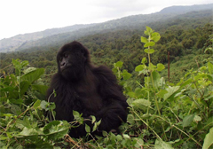
Only about 700 mountain gorillas still exist in the wild, and they live in two
conservation areas in Central Africa. Both mountain rainforest habitats are
under constant threat from subsistence farmers and from refugees from local
conflicts who are trying to clear the land for agriculture. Courtesy of the
Dian Fossey Gorilla Fund International.
Determining where locals have cleared small patches of land to plant crops or
graze cattle has always taken an enormous effort by foot, says Dieter Steklis,
an anthropologist and scientific director of the Dian Fossey
Gorilla Fund International. In the early 1990s, it became “pretty clear”
that there were “serious problems” with the ape population, he says,
and something had to be done.
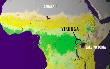
But monitoring the Virunga Conservation Area, for example — one of two
remaining gorilla habitats, which lies in parts of Rwanda, Uganda and the Democratic
Republic of Congo — has been no easy task. The area, “an island surrounded
by subsistence agriculture,” Steklis says, encompasses bits of three countries
that all have ongoing political conflicts — “so you couldn’t
simply walk across the border” from one country to another through the
park. Conservationists needed to find another method that didn’t involve
monitoring on foot, he says. And “satellite technology offered itself as
the technology that could get around these issues.”
 Satellite
images can show both the big picture, such as regional land-use changes, and
the smaller picture of where a specific patch of forest has been cleared, which
can then be checked on foot, says Andrew Plumptre with the Wildlife
Conservation Society (WCS), who works on the issue in Uganda. So Nadine
Laporte, a biologist and remote-sensing specialist with Woods Hole Research
Center, created a project designed to track land-use and land-cover changes
in these tropical wilderness areas, in partnership with NASA, the U.S. Agency
for International Development and WCS. The goal of the project, called INFORMS
(Integrated Forest Monitoring System for Central Africa), is to measure and
assess the amount and rate of forest loss in the Albertine Rift area (a large
area that encompasses part of Virunga), and to then bring the results to the
attention of local policy-makers from Uganda, Rwanda, Burundi, Tanzania and
the Democratic Republic of Congo, Plumptre says.
Satellite
images can show both the big picture, such as regional land-use changes, and
the smaller picture of where a specific patch of forest has been cleared, which
can then be checked on foot, says Andrew Plumptre with the Wildlife
Conservation Society (WCS), who works on the issue in Uganda. So Nadine
Laporte, a biologist and remote-sensing specialist with Woods Hole Research
Center, created a project designed to track land-use and land-cover changes
in these tropical wilderness areas, in partnership with NASA, the U.S. Agency
for International Development and WCS. The goal of the project, called INFORMS
(Integrated Forest Monitoring System for Central Africa), is to measure and
assess the amount and rate of forest loss in the Albertine Rift area (a large
area that encompasses part of Virunga), and to then bring the results to the
attention of local policy-makers from Uganda, Rwanda, Burundi, Tanzania and
the Democratic Republic of Congo, Plumptre says.
Scientists are using satellite images
to track land-use changes in Africa. The bright green indicates evergreen forests
(including the mountain gorilla habitat in Virunga Conservation Area); the light
yellow is agriculture; the bright yellow indicates savannas; the tan is open
shrubland; and the gray indicates desert, devoid of vegetation. Boston University
and NASA Goddard Space Flight Center.
These countries have “very limited resources to manage their natural resources,”
Laporte says. Many of the governments do not have maps of the parks, “and
the few maps they have seem to be from the 1940s, with rivers up to 20 to 30
kilometers off-course,” she says, and they also do not have many images,
photos or datasets. Laporte’s hope in creating INFORMS is that the free
Landsat images can be used for updating national geographic databases to help
these countries with their conservation efforts, she says.
To view the land-cover changes, the INFORMS scientists use several types of
satellite images that offer “different and complementary views” of
the landscape, says Jacqueline LeMoigne of the NASA Goddard Space Flight Center.
On clear days, MODIS and Landsat satellites provide snapshots of the landscape
at different resolutions, showing trees and activities at the surface over areas
that are 30 meters to 1 kilometer wide. Radar images taken from other satellites
can “see” through clouds covering the mountain rainforest to show
elevation changes from land cover or topography.
Each type of satellite image has its pros and cons, LeMoigne says, so the researchers
put together various images to create composites that show types of land cover,
amounts of land cover and spatial distribution of biomass. Radar images make
it relatively easy to distinguish the distances between trees or homesteads,
but difficult to tell what types of trees are in a patch of forest — something
nonradar satellite images do well. And among images in the visible-light spectrum,
it helps to have both Landsat and MODIS because Landsat provides closer images
less frequently (every 16 days), whereas MODIS images are taken more often but
are lower resolution.
Regardless of the type of images used, however, to validate what the satellites
show, the researchers still need people on the ground to integrate field observations,
or “ground truth,” Plumptre says. Satellite images in combination
with ground-truthing are “more cost-effective” than having teams of
people trying to cover these large areas alone, he says.
“Satellite images offer you a snapshot of the world quickly and accurately,”
Laporte says, and comparing images taken days, weeks, months and years apart
shows how the landscape has changed and continues to change. And, she says,
the images show that things are changing fast.
In June 2004, for example, farmers cleared 15 square kilometers of land within
Virunga Conservation Area (6 percent of mountain gorilla habitat in the park)
for cattle pastures and agriculture. “Satellite image analysis was used
to bring attention to the area encroached and helped create the press attention
needed to remove the farmers from the area,” Plumptre says.
From satellite images, the researchers have also detected a marked loss of several
thousand square kilometers of forests in the region surrounding the protected
areas. The loss of forests around the park’s borders only solidifies the
concern that as the human population grows and expands, pressures on the protected
areas will continue to mount, Plumptre says.
Although mountain gorilla populations have grown slightly over the past 20 years,
the two remaining habitats are surrounded by humans, and the demand for agricultural
land continues to grow, Laporte says. “About 90 percent of the population
in this area relies on the land for cash crops or subsistence agriculture, and
they still have so many problems such as AIDS and poverty that it’s very
difficult to tell them that they can’t clear land to grow food to feed
their families,” she says. People might recognize that deforestation creates
a long-term problem, but if it comes down to “how am I going to feed myself?”
— that trumps deforestation concerns, she says. “But we have to continue
to try and educate people and help them to conserve their forests.”
In the Albertine Rift, satellite imagery has already been used to help design
a United Nations Development Programme/Global Environmental Facility project
to conserve the forests. The project examines possible incentives to encourage
people to leave trees on their land or actively plant trees for fuel and building,
Plumptre says. And when the scientists are working in the field, Laporte says,
“we frequently run across farmers and show them in the satellite images
where new fields have been opened and cleared, and discuss deforestation and
sustainable agriculture.” Even reaching one farmer “can make a small
but important difference.”
Although remote sensing is already in use in various conservation projects worldwide,
including monitoring invasive species in Colorado and deforestation in Brazil,
these researchers would like to see more satellite images incorporated into
conservation efforts. The application will become more widespread as costs decline
and the technology becomes more user-friendly, says Steklis of the Dian Fossey
Gorilla Fund (which is not involved in the INFORMS project). “We’ll
be able to put together information on animal distribution, movements, behaviors”
— even the types of vegetation they use for food and the types they seek
refuge in, he says.
Presenting visual images and quantitative data about animal and habitat behavior
to policy-makers, Steklis says, can be “very powerful and persuasive, leading
to decisive actions on the parts of governments.” Remote sensing, he says,
“is a tool that really makes a difference. And if we can save a habitat,
we save everything that’s in it.”
Megan Sever
Links:
INFORMS
project
Dian
Fossey Gorilla Fund International
Wildlife
Conservation Society
Back to top
 |
Geotimes Home | AGI Home | Information Services | Geoscience Education | Public Policy | Programs | Publications | Careers |