
|
|
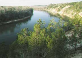
Alum Bluff near Tallahassee, Florida
[Alum Bluff. Photo by Guy
Means, Florida Geological Survey]
As the Apalachicola River has migrated eastward, it has cut and exposed Floridas tallest natural exposure of geology at Alum Bluff. This bluff, one of several along this portion of the river, stands 172.5 feet above sea level and generally is about 140 feet above the river surface during normal flow conditions. This unique area of the state harbors a great diversity of scenery sure to please anyone willing to take the time to explore it.
Since most of Floridas landscape has little topographic relief, geologists have conducted numerous studies of the stratigraphy and paleontology of this uniquely tall outcrop. The stratigraphic units exposed at Alum Bluff include siliciclastic and carbonate units, some of which harbor diverse assemblages of mollusks. The molluscan assemblages found at Alum Bluff have attracted amateur and professional paleontologists and collectors from around the world.
To access the trailhead: Drive south on State Road 12, turn right onto Garden of Eden Road, a dirt road about 1.2 miles north of the intersection of State Road 12 with State Road 20. Go west on Garden of Eden Road 2 miles to a fenced area. Park here and follow the trail signs to Bluff Overlook. The 2-mile hike is strenuous, but worth the time.
The staff of the Arkansas Geological Commission recommends the Ponca Wilderness Area that overlooks the upper Buffalo National River. The magnificent bluffs lining the river expose strata of Ordovician and Mississippian ages. The area sports an old lead and zinc mining district, numerous caves, small-mouth bass fishing, camping, hiking, photography, wildlife, and several modern and ancient karst features and valleys to explore. Local outfitters rent out canoes and lodging. There are several campgrounds along the river or you can float down the river and camp on a gravel bar (one of my favorite ways to camp). Low water flow usually limits summer canoeing, but it also reduces the number of people visiting the area, giving the hiker or backpacker a true wilderness experience.
State Geologist Mimi Garstang recommends the Maramec Spring Park near Rolla and St. James, which features trout fishing as well as an abandoned iron and hematite mine and an iron workings. Phone: 573/265-7387 or visit the Web site (click on St. James Community and then on Maramec Spring Park).
Garstang also recommends Elephant Rocks State Park: The granite elephant rocks have the appearance of huge animals roaming the hillsides. Phone: 573/697-5395. Web: www.mostateparks.com/elephantrock.htm
 |
Geotimes Home | AGI Home | Information Services | Geoscience Education | Public Policy | Programs | Publications | Careers |