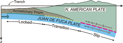
[At left: Schematic of subduction zone showing fully locked and partially locked transition zones (source of next great earthquake) and the deeper zone where the slip event occurred.]

The equivalent of a magnitude-6.7 earthquake jostled the coast of Washington in the summer of 1999 and no one even rolled over in bed. No pictures fell off walls, no glassware broke. It was a silent earthquake that struck the Pacific Northwest without any brittle rupture or shockwaves a quake that lasted more than a month, making it almost imperceptible at ground level. Watch out. These slow shifts of the earth can be quiet doomsayers.
Scientists from the Geological Survey of Canada reported in the April
19 Science that seven continuous GPS (Global Positioning System)
receivers in southwest British Columbia and northwest Washington that had
been slowly and steadily moving northeast, suddenly and briefly switched
their direction with no seismicity recorded.
[At left: Schematic of subduction
zone showing fully locked and partially locked transition zones (source
of next great earthquake) and the deeper zone where the slip event occurred.]
Herb Dragert and colleagues from the survey explained the unexpected motion displacements in the other direction as a plate slip of about 2 centimeters that occurred over an area 50 kilometers by 300 kilometers on the interface of the Cascadia subduction zone. The slip lasted from Aug. 18 to Sept. 22, 1999, as it propagated from the southeast to the northwest. The silent earthquake rippled in less than 5-millimeter increments from just south of Seattle to central Vancouver Island at a depth varying from 25 kilometers to 45 kilometers. The total plate slip was equivalent to roughly half a year of plate convergence.
One question that arises from this quake is whether silent earthquakes can be used to predict shallow thrust earthquakes where the movement is fast and ruptures the ground above the fault. In several documented cases Chile in 1960 and Nankai Trough, Japan in 1944 and 1946 silent earthquakes preceded giant thrust earthquakes.
But with so many uncertainties about earthquake initiation, it is very misleading to link silent or slow events directly to earthquake prediction, says geophysicist Hiroo Kanamori of the California Institute of Technology. Even if slow events represent an important stress accumulation process before a large earthquake, [they] cannot be used directly for prediction.
Silent earthquakes may not be good predictors of larger thrust quakes, but they can be used to begin to assess stress buildup along fault zones. Until the Pacific Northwest event, it had been generally assumed that deeper slip along the Cascadia subduction zone occurred steadily.
The discovery that such events do take place indicates that the rate of stress accumulation is not steady but can occur in pulses, Dragert says. For the magnitude of the deep slip that we observed, we estimate that it would take somewhere in the neighborhood of 100 such slip events to bring the locked zone to failure.
Dragert adds that because scientists do not know the current stress level on the fault, they cannot say whether this last slip event brings the locked zone perilously close to that critical stress level required for rupture.
Stress is continuously building along the shallow locked portion of the subduction interface. Any slip on the deeper part of the subduction zone increases the stress load, bringing the locked thrust zone closer to failure. Many scientists agree that one of these sudden deep-slip pulses could ultimately trigger a megathrust earthquake in the Pacific Northwest.
The observation of this silent earthquake does not change the perceived risk of a large-scale thrust earthquake along the Cascadia subduction zone, Dragert says. The Cascadia subduction zone has long been noted as being at risk for a giant thrust earthquake. Large quakes have occurred along this subduction zone every 200 to 700 years, with the last major quake occurring in 1700. There is evidence of seven great earthquakes over the past 3,500 years along the coast of southern Washington. The Cascadia subduction zone stretches about 1,000 kilometers along the coast of Oregon, Washington and British Columbia where the oceanic Juan de Fuca plate drives beneath the continental North American plate.
Observation of this silent earthquake emphasizes the need for closer monitoring of crustal motions along the Cascadia margin, Dragert says. Denser continuous GPS networks spanning Puget Sound and Georgia Strait are needed to characterize the timing and the spatial distribution of these silent earthquakes and to better understand the role they play in the seismic hazard of the Pacific Northwest.
Although this earthquake does not conclusively indicate that the Pacific Northwest is significantly closer to the Big One, there is always a need to reassess hazards on the basis of new findings, Kanamori says. This is the way we have made progress.
Megan Rudolph
Geotimes contributing writer
 |
Geotimes Home | AGI Home | Information Services | Geoscience Education | Public Policy | Programs | Publications | Careers |