Geotimes

Web
Extra Thursday,
June 5
Models of Iraq's toxic plume
under fire
 In March 1991,
after the first Gulf War, U.S. army demolition planes bombed a chemical weapons
depot in southeastern Iraq. They destroyed hundreds of 122-millimeter rockets
containing sarin and cyclosarin, releasing the deadly nerve agents into the
air.
In March 1991,
after the first Gulf War, U.S. army demolition planes bombed a chemical weapons
depot in southeastern Iraq. They destroyed hundreds of 122-millimeter rockets
containing sarin and cyclosarin, releasing the deadly nerve agents into the
air.
On Monday, congressional auditors announced that atmospheric dispersion models
used to estimate the path the toxic plume followed after the bombing were flawed
and may have greatly underestimated the number of soldiers exposed to the chemicals.
They recommended that Congress ask the Pentagon raise the number of soldiers
presumed to have been exposed, from 100,000 to 700,000 -- the total number of
soldiers who fought in the war.
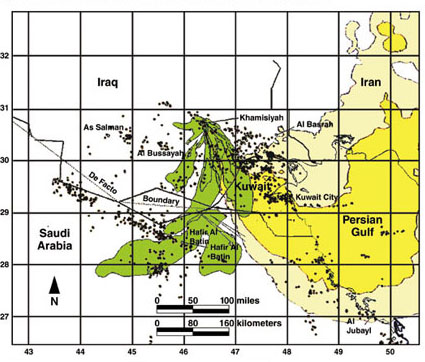
A Department of Defense composite model (green) and Lawrence Livermore National
Laboratory model (yellow) calculated very different paths for the toxic plume
after the demolition bombing in Khamisiyah. Each dot represents a troop unit's
location or part of a unit's location. Figure courtesy of GAO.
"In general, modeling is never precise enough to draw definitive conclusions,
and the Department of Defense did not have accurate information on source term
(such as the quantity and purity --concentration -- of the agent) and meteorological
conditions (such as the wind and weather patterns), essential to valid modeling,"
according to a preliminary assessment by the U.S. General Accounting Office
(GAO). Keith Rhodes, chief technologist at GAO, presented the assessment to
the House Subcomittee on National Security, Emerging Threats, and International
Relations at a hearing on Monday.
The GAO report concluded that if an ensemble of validated models captured all
the uncertainties inherent in the input data, the footprint for the area of
risk would greatly increase and probably encompass the whole area where U.S.
and other coalition forces were deployed in Iraq.
The Department of Defense and the Central Intelligence Agency began the modeling
efforts in the mid 1990s in the midst of rising concern that chemicals released
during the demolition bombing may have contributed to Gulf War Syndrome, a loose
term that refers to a variety of symptoms afflicting many veterans including
memory loss, rashes, equilibrium problems and loss of motor skills. Since the
modeling began, the Pentagon has increased estimates of the number of people
presumed exposed from zero to 400 in 1996 and 100,000 in 1997. Concerned that
the most recent plume models still underestimate the zones of risk, the subcommittee
asked GAO to independently assess the models.
The GAO auditors interviewed agency officials and modeling experts within the
government and academia, and reviewed the Department of Defense's methodology
and analyses of plume modeling.
They found that data on wind speed and direction at the bombing site, Khamisiyah,
were extremely limited, making it impossible to determine, with any high degree
of accuracy, which direction the plume headed. The main reason for sparse data
is that Iraq stopped reporting its weather station measurements to the World
Meteorological Organization in 1981. The only data available came from surface
measurements made 80 to 90 kilometers from the bomb site, and from upper atmosphere
measurements made 200 kilometers away.
"It's not a surprise," says Eric Barron, an atmospheric scientist
at Penn State University and chair of the National Academy of Science's Committee
on the Atmospheric Dispersion of Hazardous Material Releases. "You have
a particular view of the [initial] atmospheric conditions and then that model
steps forward in time, attempting to predict the flow. If you have very limited
observations, it's a challenge to predict how that dispersion would step forward
in time."
The Department of Defense models also made a critical mistake by assuming that
that the plume remained in the bottom 100 meters of the atmosphere at all times,
Rhodes said. The physics of the bombing did not justify this assumption. The
plume may have, in fact, reached 400 meters or more, which would have allowed
strong winds not present at the surface to transport the nerve agents over a
much broader area, according to the report. Strong winds near 200 meters often
develop at night, which is when the bombing occurred.
The Department of Defense and CIA not only worked with limited data, but also
averaged the outputs of several different models, masking considerable variability
that existed among them, Rhodes said. Rep. Christopher Shays (R-Conn.), chairman
of the subcommittee agreed: "DOD combined several inhouse systems, rather
than select one validated modeling approach, in the apparent hope cumulative
strengths would outweigh combined weaknesses. But at some point, even the attempt
to err on the side of caution produced more error than caution."
The Department of Defense also chose not to include in its averages one model
that gave a completely different view of where the plume spread. The Atmospheric
Release Advisory Center at Department of Energy's Lawrence Livermore National
Laboratory developed a model showing that the plume first headed south but then
turned east and spread over a wide area. A composite of all the Department of
Defense models shows the plume started out heading south, as well, but then
turned west and remained tightly confined.
Resolving how to use the plume models, if at all, has practical consequences
for veterans, Rhodes says. If the Pentagon does change the status of all veterans
to "presumed exposure," then the Department of Veterans Affairs medical
centers will have to treat any veteran with signs of nerve agent illnesses.
As of now, soldiers outside the Department of Defense's modeled plume must prove
that they were exposed before they receive treatment; many must seek their own
medical care.
Greg Peterson
