
The 1930s Dust Bowl years marked an unusual period in the climate history of
the United States. Now scientists examining ice cores from Greenland have reason
to believe that the Dust Bowl years were an even greater meteorological fluke
than previously documented.
 Most of the dust
that makes its way around the globe to settle on the snow and ice of the Greenland
ice cap is known to come primarily from China and Mongolia, based on evidence
of the mineral particles found. But some researchers, seeing discrete spikes
in the ice record, have suggested that the dust that lofted into the air during
the dry and windy episodes that struck the Great Plains region of the United
States between 1930 and 1940, specifically during 1935 and 1936, may have left
a fingerprint in Greenland's ice. But until now none have shown enough evidence
to convince the scientific community that the dust indeed marked its territory
that far north.
Most of the dust
that makes its way around the globe to settle on the snow and ice of the Greenland
ice cap is known to come primarily from China and Mongolia, based on evidence
of the mineral particles found. But some researchers, seeing discrete spikes
in the ice record, have suggested that the dust that lofted into the air during
the dry and windy episodes that struck the Great Plains region of the United
States between 1930 and 1940, specifically during 1935 and 1936, may have left
a fingerprint in Greenland's ice. But until now none have shown enough evidence
to convince the scientific community that the dust indeed marked its territory
that far north.
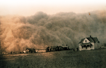
This photo, taken April 18, 1935, shows
a dust storm approaching Stratford, Texas. Photo courtesy from NOAA George E.
Marsh Album.
Much of the skepticism comes in part because no known period in Greenland's
ice record to date has shown a dust trail from North America. So it was with
caution that geologist John Donarummo Jr. and physicist Michael Ram, both of
the University of Buffalo in New York, along with biologist Eugene Stoermer
of the University of Michigan in Ann Arbor, presented the evidence supporting
their find of Dust Bowl dust in Greenland. "We didn't find a smoking gun,"
Donarummo says. But if presented in a court of law, the evidence, he says, would
be enough to convince a jury. "It shows that when conditions are right,
the continental U.S. can contribute a significant amount of dust," Donarummo
says. "The end goal is to understand how dust behaves and how it contributes
to climate."
In their report published in the March 18 Geophysical Research Letters,
Donarummo and his co-authors presented three lines of evidence for Dust Bowl
dust in Greenland's ice sheet summit: they dated the dust and found that it
arrived in Greenland between 1933 and early 1934; the clay minerals of the dust
correlate with either an American or African origin; and the diatoms they found
— the silica shells of aquatic algae that can travel with the wind —
were all common North American species, although not diagnostically North American.
Pierre Biscaye of the Lamont-Doherty Earth Observatory at Columbia University,
who with colleagues was first to report the East Asian source of Greenland dust,
and who has continued to study that source, criticized their analytical methods
but agreed with their conclusion. "I believe they have shown for the first
time dust other than from China/Mongolia in Greenland."
Donarummo and his colleagues based their standard for what distinguishes one
clay mineral source from another on Biscaye's analysis of dust in Greenland
ice and snow. However, the samples Donarummo and Ram collected were too small
to have been analyzed using either bulk X-Ray diffraction or strontium and neodymium
isotopes, as Biscaye and colleagues had done. Instead, they used a Scanning
Electron Microscope (SEM) to analyze the particles seen in the ice. "They
had to use SEM because of the small size of their samples, but the standard
for where they say the dust comes from is our literature and strictly speaking,
they should have used a standard from the source area that's based on SEM,"
Biscaye says. He adds that his point is a technical one and the quality of their
evidence, nonetheless, indicates the weather did indeed throw the planet a small
curve-ball in terms of wind patterns in 1933.
"It certainly has not been a very frequent transport pathway," Biscaye
says. "It took an extraordinarily unusual circumstance to allow that 1933
dust to be transported to Greenland, if, as it seems, it is from the southwestern
U.S. It must, however, have been an enormous quantity of Dust Bowl dust in order
for it to have swamped the usual Chinese/Mongolian dust signal that was surely
transported to Greenland that year."
Christina Reed
Back to top
 Last year, a field
crew from the National Geodetic Survey (NGS) and Louisiana State University
(LSU) drove a 70-mile stretch of road along coastal Louisiana. A GPS receiver
mounted to the back of their van continually measured the height of the road.
Similar crews had measured the road heights in 1993 and in 1982. The conclusion:
the road, which spans much of the wetland areas west of the Mississippi River,
has been sinking, and sinking quickly, up to a foot per decade.
Last year, a field
crew from the National Geodetic Survey (NGS) and Louisiana State University
(LSU) drove a 70-mile stretch of road along coastal Louisiana. A GPS receiver
mounted to the back of their van continually measured the height of the road.
Similar crews had measured the road heights in 1993 and in 1982. The conclusion:
the road, which spans much of the wetland areas west of the Mississippi River,
has been sinking, and sinking quickly, up to a foot per decade.
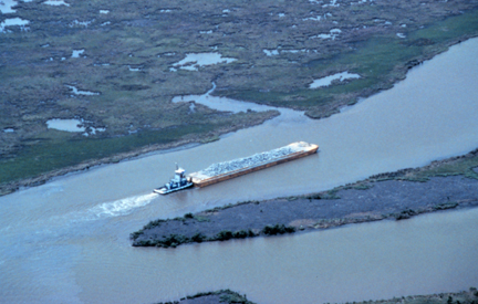
A tugboat pushes a barge load of rock
up Locust Bayou in Point au Fer Island, Louisiana. A NOAA restoration project,
completed in 1997, used the rock as riprap to protect the island's coast from
erosion. Every year, land subsidence and sea-level rise allow the Gulf of Mexico
to creep farther inland, drowning marshes and increasing the risk of damaging
storm surges. Photo from NOAA Restoration Center, Erik Zobrist.
Resource managers have long known that coastal Louisiana is sinking; each year,
hundreds of acres of wetland sink below sea level, inundated by the Gulf of
Mexico. At the same time, the new NGS data indicate that subsidence rates are
nearly double past estimates. On April 17, Charlie Challstrom, director of NGS,
a branch of the National Oceanic and Atmospheric Administration (NOAA), presented
the subsidence rates at the National Hurricane Conference. With hurricane season
right around the corner, he warned that subsidence would increase the likelihood
of coastal flooding.
Scientists at NGS and LSU estimate that at the current rate of subsidence, 15,000
square miles of land along south Louisiana will be at or below sea level within
the next 70 years, according to a NOAA press release.
The new elevation data will be used to fine-tune storm surge projections, says
Paul Trotter, a meteorologist at the National Weather Service in New Orleans.
Most damage during coastal storms comes when sea level rises quickly, and a
wall of water that can be greater than 20 feet high advances inland.
Forecasters at the National Hurricane Center will incorporate the new road heights
to predict how far those storm surges will advance, Trotter says. "A difference
of a foot in elevation means that the storm surge could go hundreds of meters
farther inland."
Shea Penland, a geologist at the University of New Orleans, warns that the high
rates of subsidence measured along the road, which have not yet been published
in a peer-reviewed journal, may not give an accurate picture of what is happening
in coastal Louisiana as a whole. "You shouldn't extrapolate from manmade
objects into a natural landscape; that would be mixing apples and oranges,"
he says.
The roads, and the cars pounding along the roads, add weight, creating local
compaction rates that may be higher than those in the surrounding wetlands,
Penland says. Compaction is particularly prevalent in coastal Louisiana, which
sits on relatively unconsolidated sediments that have accumulated over the past
5,000 years. In addition, Penland says, wetland areas accumulate sediment and
organic matter over time, adding height that offsets subsidence. The road calculations
do not include accumulation. That omission may exaggerate the severity of the
problem, he says.
Geologist Sherwood Gagliano, president of Coastal Environments Inc. in Baton
Rouge, says that accumulation rates can be as high as a third of a foot per
decade. That rate would offset the recent NOAA-LSU subsidence measurements by
roughly a third.
Robert Morton, a geologist at the U.S. Geological Survey Center for Coastal
& Watershed Studies in St. Petersburg, Fla., also cautions against extrapolating
current rates of subsidence into the future. His research indicates that oil
and gas drilling in coastal Louisiana has been causing a substantial amount
of the subsidence in the region. Removing the petroleum and associated water
reduces belowground pressure, which can trigger blocks of wetland to drop. Most
of the wetlands in coastal Louisiana sit on irregularly shaped blocks defined
by faults that run 25,000 to 40,000 feet deep. Because oil and gas production
peaked in the 1970s, and has continued to decline since then, Morton expects
that subsidence rates will lessen over time.
Resolving the true rate of current and future subsidence is at the heart of
long-term efforts to restore Louisiana's coast, Morton says. Responding to rapid
land loss, a host of federal, state and local resource management agencies have
constructed Coast 2050, a plan that outlines steps to regenerate wetlands. Hallmarks
of the $14 billion plan to be submitted to Congress include reinforcing existing
barrier islands and allowing more of the Mississippi River to flood coastal
regions. Dams and levees along the river have reduced, by more than half, the
amount of sediment that the river carries and deposits to wetlands, Gagliano
says.
"The rates of subsidence are obviously critical," Morton says. "If
the land is going down a foot every 10 years, why bother? Why spend that much
money?" he asks rhetorically, noting that subsidence of that rate would
outpace restoration efforts. If the rates are lower, as he believes, restoration
becomes more plausible.
The NOAA-LSU data are still brand new, says Bill Good, an ecologist at the Louisiana
Department of Natural Resources, and a lead developer of Coast 2050. "People
have not had a chance to digest it yet, to evaluate it and compare it with other
data." But, he adds, properly incorporating the data will be extremely
important: "We don't want to start a project and have it submerged before
we are done."
Greg Peterson
Back to top
 |
Geotimes Home | AGI Home | Information Services | Geoscience Education | Public Policy | Programs | Publications | Careers |