
 Over the
first weekend of May, California fell into the sea during a television miniseries
aired by NBC. In addition to the other faulty geologic premises of the melodrama,
one elemental error is the size of the earthquake that spawned the miniseries’
disasters: a magnitude 10.5 on the San Andreas Fault. Seismologists unanimously
and immediately responded that such a large earthquake is not possible on that
fault, and perhaps nowhere in the world. And scientists continue to refine methods
to calculate the largest earthquake that could occur on any fault.
Over the
first weekend of May, California fell into the sea during a television miniseries
aired by NBC. In addition to the other faulty geologic premises of the melodrama,
one elemental error is the size of the earthquake that spawned the miniseries’
disasters: a magnitude 10.5 on the San Andreas Fault. Seismologists unanimously
and immediately responded that such a large earthquake is not possible on that
fault, and perhaps nowhere in the world. And scientists continue to refine methods
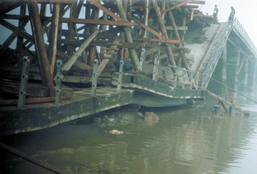
to calculate the largest earthquake that could occur on any fault. The first shock of the 1960 Chilean earthquake — the largest recorded in history at magnitude 9.6 — destroyed two spans of this bridge; three more spans collapsed during the second shock. The quake ruptured 1,000 kilometers of fault — more than has ever occurred on the San Andreas Fault, where seismolgists say a magnitude-10.5 earthquake would be impossible. Image courtesy of the National Information Service for Earthquake Engineering, University of California, Berkeley.
Conventional wisdom says that the length of a fault determines how big an earthquake could be. In addition to length, says David Schwartz of the U.S. Geological Survey in Menlo Park, Calif., such an assessment includes “the thickness of the seismogenic crust and the amount of slip that occurs” along the fault.
For reference, Schwartz points to the largest recorded earthquakes on the planet: The 1964 Good Friday earthquake in Alaska was magnitude 9.2, and a Chilean earthquake in 1960 hit 9.6. “The Chilean earthquake, I believe, was about a thousand kilometers of rupture. That’s the entire San Andreas Fault from the Gulf to Mendocino,” he says.
But the San Andreas Fault has not ruptured along its entire length all at once. Schwartz notes that the Chilean and Alaskan earthquakes occurred at subduction zones: “Megathrusts can produce those very large earthquakes,” he says. Because the San Andreas Fault is on land, where the crust is thinner, the fault presents a different set of circumstances. “If you want a super-earthquake in California, a magnitude 9, you have to find a place to put it, and we don’t have any faults capable of doing that,” Schwartz says.
And at the highest magnitudes, greater and greater lengths are necessary to up the ante, says Schwartz, who is currently studying the three fault segments that ruptured during the 2002 magnitude-7.9 Denali earthquake in Alaska. Even if the entire 350 kilometers of the Denali Fault ruptured and jumped to another fault, it would need another 350 kilometers to increase even slightly, to a magnitude 8.2, he says. “I would maintain that the maximum size is going to be governed by the dimensions of the fault.”
Dave Jackson of the University of California, Los Angeles, disagrees. In an abstract submitted to the Seismological Society of America for a meeting held last April, Jackson and his colleagues wrote that they are reassessing a statistical relationship that correlates fault size with maximum earthquake size, using a catalog of mapped faults and associated earthquakes. He notes that many of the recorded earthquakes did not rupture their entire fault length, while others jumped faults, in effect increasing their fault lengths.
Jackson cites several events, such as the 1992 Landers earthquake in Southern California, that partially ruptured along one fault and then jumped to several others, rupturing a length and area greater than the original fault alone may have done. He also says that the consideration of distribution of earthquakes of different sizes along a fault may be throwing off calculations of maximum magnitude.
“All the [regional] slip comes from a distribution of earthquake sizes — a lot of little ones, some medium ones, not so many large earthquakes,” he says. Tracking their distribution over time and space allows for a kind of “budgeting” that can then be used for estimating the magnitude of the largest earthquake. But a short historic record of earthquakes on all of California’s faults means that the very largest earthquakes, which may have occurred deeper in geologic time, might be missing from the budget.
Both Jackson and Schwartz agree that paleoearthquake data are important to consider in assessing future seismic hazards. And in the end, forecasting earthquakes relies on a variety of models to produce probability maps, not concrete numbers of magnitude. Current scenarios set “the Big One” in California at just over magnitude 8 — and they never predict that the state will fall into the sea.
Naomi Lubick
Links:
NISEE at the University of California, Berkeley, and the Karl Steinbrugge Image Database
USGS Web site on "mega-quakes"
