
 As Earth spins
in space, the North Pole continually shifts as the planet’s axis wobbles
like a top. Factors such as winds, ocean currents and changes in Earth’s
interior all affect the quivering axis, but scientists have not been able to
identify exactly what drives the annual wobble. A new study, however, says that
the shifting of masses of water and ice around the globe’s surface primarily
drives the seasonal wobble. The finding could lead to new ways to monitor global
change.
As Earth spins
in space, the North Pole continually shifts as the planet’s axis wobbles
like a top. Factors such as winds, ocean currents and changes in Earth’s
interior all affect the quivering axis, but scientists have not been able to
identify exactly what drives the annual wobble. A new study, however, says that
the shifting of masses of water and ice around the globe’s surface primarily
drives the seasonal wobble. The finding could lead to new ways to monitor global
change. Until now, models had attempted to explain the minor daily variation in the North Pole, but “why Earth is wobbling has never really been demonstrated directly,” says co-author Geoffrey Blewitt, a geophysicist at the Nevada Bureau of Mines and Geology and Seismological Laboratory at the University of Nevada, Reno. “On timescales of up to several years, we believe that the dominant effect must be due to changes in mass on Earth’s surface, rather than anything deeper down in Earth.”
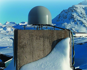
GPS stations, such as the one shown here in Kulusuk, Greenland, could help researchers monitor the shifting of masses of ice and water around the planet. Such shifting likely contributes to why Earth wobbles on its axis. Image from van Dam et al., EOS, 81, pp. 426-427, 2000; courtesy of Tonie van Dam.
Reconciling the many factors that affect Earth’s wobble on varying timescales has proven daunting for scientists. Fortunately, several systems are in place to monitor them. For example, satellites, such as the recent GRACE mission, monitor changes in Earth’s gravity field. In addition to satellite systems, several other techniques, including lunar-laser ranging and very long baseline interferometry, can measure changes in Earth’s rotation rate, which is affected by the planet’s mass distribution. And precisely placed GPS receivers can monitor changes in Earth’s shape —another indicator of mass distribution.
Combining these techniques, a team led by Richard Gross of NASA’s Jet Propulsion Laboratory (JPL) has successfully isolated the cause of the annual wobble. Using GPS data collected between 1997 and 2000, they predicted how the position of the North Pole would vary given changes in Earth’s mass distribution. The team then compared the predicted wobble to the direct observations of the axis made during the same period by satellites and very long baseline interferometry. What they found was a match, as reported in their study in the April Geophysical Research Letters.
The fact that the two very different methods gave the same result shows that scientists are on the right track to understanding the physical processes that affect Earth’s mass balance, says Xiaoping Wu, a geophysicist at JPL. “That several different techniques converge to show the same thing is a very encouraging sign,” Wu says.
In the future, the study’s findings may allow researchers to pinpoint mass changes by looking at the wobble or to monitor global climate change by tracking mass changes around the planet with GPS. For example, over a 10-year period, scientists could detect mass changes due to melting of the Greenland ice sheet. “As that water is released from Greenland, it gets distributed evenly throughout the oceans; it changes the shape of Earth, and we could measure that change,” Blewitt says. “So we could backsolve and try to figure out where that mass is moving from and where it’s moving to, and hopefully, we’ll be able to say something about the balance of ice sheets in Antarctica and Greenland.”
Meanwhile, Wu says, scientists are striving to understand how the distributed components of Earth’s mass and the processes that affect them work together as a whole system. For that to happen, more data from GPS and other measurement systems are necessary, he adds, especially over the oceans where coverage is now sparse.
Sara Pratt
Geotimes contributing writer
Back to top
