 In that first course,
Quinn says, the climatology maps were difficult to decipher. “There was
no way to make it better than what they had,” he says, with “wind
lines going everywhere,” etched in plastic pages. But now Quinn, who had
some sight until he was 5 years old, was able to see the solar system and stars
through complex “thermoform” models that Hurd, an astronomer and atmospheric
scientist, and his colleagues have developed to convey the stars and universe
in plastic.
In that first course,
Quinn says, the climatology maps were difficult to decipher. “There was
no way to make it better than what they had,” he says, with “wind
lines going everywhere,” etched in plastic pages. But now Quinn, who had
some sight until he was 5 years old, was able to see the solar system and stars
through complex “thermoform” models that Hurd, an astronomer and atmospheric
scientist, and his colleagues have developed to convey the stars and universe
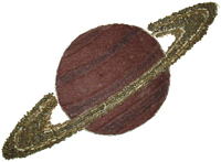
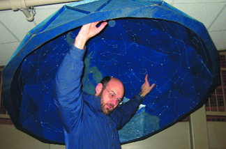
in plastic.David Hurd stands inside a full-tactile dome of the night sky, which he designed and made with John Matelock at Edinboro University of Pennsylvania. Above: Hurd’s original model of Saturn, rendered in felt and sand. Images courtesy of David Hurd.
Using string, beads and other materials, Hurd and John Matelock, a tactile illustrator and engineer for the university, made a full-sky star chart be heating plastic sheets that raised in relief over the model’s surfaces in a vacuum sealing process. The star chart is completely labeled in Braille, with a dial to set the date and time. To create the swirl of sunspots on the sun, Hurd used doll hair, and to create Saturn’s rings, he used different grain sizes of sand. His team used the same technique to create tactile models of the Moon and its mares and of the Cassini-Huygens mission to Saturn. Each master model is a piece of art in sawdust, glue and felt.
For the past three semesters, Hurd says that he has had at least one blind student in his introductory astronomy course. “It’s become my passion over the past five or six years,” he says, and though the course is still highly visual, “it’s accessible to special-needs students.” Both trained as geologists, he and Matelock also created a “killer tactile of the Grand Canyon,” Hurd says. “The emphasis is, if the student is there, we have to make every effort to make sure that they are experiencing the same thing as other students.”
That philosophy is part of “universal design,” which advocates making teaching tools for select groups of people, in hopes of making information more accessible to all. A 1999 study from the American Foundation for the Blind estimated that 93,600 students in the United States are severely visually impaired (that number includes more than 55,000 children who are legally blind). These numbers are radically different from U.S. government counts, which show just over 27,500 visually impaired students, from ages three to 21, served under the Individuals with Disabilities Education Act in 2002. Both sets of numbers, however, indicate a large demand for alternative methods to teach all kinds of visual topics.
Cassandra Runyon, a planetary geologist at the College of Charleston in South Carolina, acts as a point person for a community of teachers interested in such alternative techniques. Her own goal is to teach visually impaired students remote sensing, an entirely visual science and to then eventually adapt her materials to blind, deaf, hearing-impaired and orthopedically impaired students.
 Runyon’s
former student Jason Permenter, now a graduate student in the geography department
at the University of Cambridge in England, has created a curriculum using 3-D
clay mountains, with brightly colored clays delineating different geologic deposits
and landscape components. Presented at the American Geophysical Union meeting
last December, the method works best for visually impaired students, Permenter
says, rather than completely blind students, though the tactile aspect of the
models is useful. He says he hopes to reach sight-impaired students who may
be turned off by the difficulty in understanding “anything in the geosciences
because it’s all visual.”
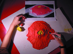
Runyon’s
former student Jason Permenter, now a graduate student in the geography department
at the University of Cambridge in England, has created a curriculum using 3-D
clay mountains, with brightly colored clays delineating different geologic deposits
and landscape components. Presented at the American Geophysical Union meeting
last December, the method works best for visually impaired students, Permenter
says, rather than completely blind students, though the tactile aspect of the
models is useful. He says he hopes to reach sight-impaired students who may
be turned off by the difficulty in understanding “anything in the geosciences
because it’s all visual.” Jason Permenter’s clay version of Olympus Mons, made according to a color-coded digital elevation model. Image courtesy of Jason Permenter.
But these physical models and other universal access teaching methods may also benefit sighted students or students with different challenges, Runyon says. After having increasing numbers of students with a variety of disabilities, she says that her father, an artist, challenged her to find new ways to get visual information across in the classroom. “Then I realized what we were doing to get things across to the disabled students was helping the other students,” she says, “in basic concepts as well as the more complex ones.”
Indeed, physical teaching models can “help everybody learn whether or not they have normal vision,” says Susan Sakimoto, a planetary geologist at NASA Goddard in Maryland. The 3-D models her team makes have proven useful in teaching classic lessons in topography, scale and vertical exaggeration, the sorts of concepts that professional scientists take for granted, she says, but for which an average middle school student “will go, ‘what?!’”
The NASA team creates scaled geologic models using a machine that makes engineering prototypes. The device lays down plastic in layers that are seven one-thousandths of an inch thick to create the 3-D models. Where models made with heated and embossed sheets of plastic tend to be smooth, the extrusion layering gives models “a contour map effect,” Sakimoto says. “As you run your fingers along, you can tell more easily if you are going at constant elevation, or uphill or downhill.”
The first pair of models made by the NASA team consists of vertical exaggerations of Mars’ Olympus Mons and Earth’s chain of Hawaiian Islands. The models, about 15 centimeters square with 3 to 6 centimeters of relief, have the same horizontal scale and are made with a vertical exaggeration of a factor of seven. Sakimoto has given the models to her education students at the Johns Hopkins University in Baltimore, and the team has shipped models to teachers across the country who have volunteered to test them. The accompanying curriculum discusses 3-D versus 2-D mapping, as well as comparing sizes and geologic processes on Earth and Mars.
Such field-testing gives the NASA team feedback on the models and curriculum. For example, Sakimoto says, one set for a group of six students seems to work, but only for sighted students who pass the models around without taking too long. Fewer students per group are necessary when teaching sight-impaired students, she says, who must touch the physical models and take more time to see them. Also, different cultural groups have different responses, according to the preliminary feedback she has received so far from teachers with Hispanic and Native American students.
Quinn, who has “beta-tested” the new materials that come out of Edinboro University and NASA, has conducted comparisons with other products as a project for Hurd. He says that in the past, available materials were “hit and miss.” But recently, Quinn says, the field has been “on an upward swing. People are starting to take more interest.”
Just this year, the National Federation of the Blind (NFB) organized its first summer camp for visually impaired students. The week-long course in July will teach middle school students about life cycles, and another camp in August will team high school students with NASA scientists to build and launch a rocket.
Barbara Cheadle, president of the National Organization of Parents of Blind Children within NFB, says that the summer camp curricula for the middle school students, who are often in earth science curricula, will include lessons on prehistoric time, archaeology and paleobiology. The students also will participate in a mapping exercise of the Chesapeake Bay and a dissection lab, which she says, is “only one of the things blind kids are often excluded from.” Ideally, NFB will create a central clearinghouse for adapted resources for teachers and students, Cheadle says. Currently, “there is no centralized place,” she says. “You have to hunt all over the place to find the equipment and materials.”
Several institutions, such as Wright State University in Dayton, Ohio, have programs that cater to college students. Wendi Williams of the University of Arkansas at Little Rock says she wants to make sure teachers are communicating and moving toward programs that work effectively. Following successful sessions at previous meetings, Williams will chair an oral session at this year’s Geological Society of America meeting in Denver that is one of four on teaching geology to disabled students, highlighting accessibility for all. And for the past two years, Williams’ geology department has served as a “guinea pig” for teaching techniques that will be applied to other disciplines at the university.
The geosciences are a good place to start because “we have toys to play with in geology and we have been creative in modifying them,” Williams says. “We’re going to be doing this across the sciences because it’s the right thing to do.”
