Geotimes

Feature
Petra: An Eroding
Ancient City
Naomi Lubick
Sidebars:
Preserving
an Afghan landmark
Conservation changes
 Tucked into
desert canyons in southwestern Jordan, carved stone facades cover red sandstone
walls, tens of meters high. Just inside the rock faces, benches line cavernous
rooms hewn there thousands of years ago. The red rock walls ring the ancient
city of Petra, where expert stonemasons made the monuments for gods, kings and
wealthy citizens.
Tucked into
desert canyons in southwestern Jordan, carved stone facades cover red sandstone
walls, tens of meters high. Just inside the rock faces, benches line cavernous
rooms hewn there thousands of years ago. The red rock walls ring the ancient
city of Petra, where expert stonemasons made the monuments for gods, kings and
wealthy citizens.
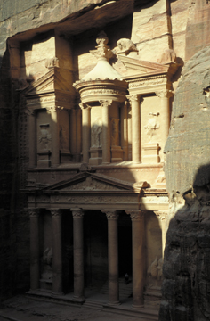
The Al Khazneh, also known as the Treasury,
is the largest monument in Petra. It sits at the entrance to the city, greeting
thousands of visitors to this cultural icon every year. All photographs by and
courtesy of Tom Paradise.
The carved rocks remain as a seemingly timeless testimony of human ingenuity
and survival in a desert that gets 15 centimeters of rain a year. Well-established
by the third century B.C., by which time a formerly nomadic people called the
Nabataeans had moved into the region, Petra became a major center of commerce
by the first century B.C. By the time the Romans took over the desert metropolis
around A.D. 100, a complex integrated system of hand-carved stone flumes (some
lined with ceramic pipes), reservoirs and 200 cisterns was capable of supplying
as much as 12 million gallons of water a day to the settled valley.
Enough to meet the needs of 100,000 people in a modern-day American city, the
water system gave life to gardens, animals and a rich urban culture in the middle
of the desert, supported by a booming spice and textile trade route. At its
height, Petra may have been home to at least 20,000 people, according to archaeologists
and curators of an exhibition of Petra artifacts in the United States, which
opened at the American Museum of Natural History (AMNH) in New York last fall
and will move to the Cincinnati Art Museum in September.
“Petra is all about water, both its productivity when harnessed and its
power of devastation when left uncontrolled,” says Glenn Markoe, curator
at the Cincinnati Art Museum. The city, which went by different names over the
centuries, had “a really elaborate water management scheme that people
are just understanding now,” Markoe says. However, the flash floods that
created the site’s canyons millions of years ago are now threatening to
destroy it, aggravated by the increasing number of humans who flock to see what
remains of the ancient site.
Controlling the flow
 The sandstone
that forms Petra’s red-faced monuments is the oldest in a series of sandstone
formations, underlain by a pre-Cambrian granite with gneiss and schist. The
oldest sandstone consists of coarse- to medium-grained quartz clasts, shot through
with an iron- and manganese-rich matrix, and varies in color from red to yellow
to chocolate.
The sandstone
that forms Petra’s red-faced monuments is the oldest in a series of sandstone
formations, underlain by a pre-Cambrian granite with gneiss and schist. The
oldest sandstone consists of coarse- to medium-grained quartz clasts, shot through
with an iron- and manganese-rich matrix, and varies in color from red to yellow
to chocolate.
Geologists have identified the formation as the remnant of a large braided stream
complex, which was then buried by another white, friable sandstone formation;
a limestone layer caps high points throughout the region. The surrounding hills
are covered with Holocene wind and stream deposits, but little vegetation. Weathering
and regional seismicity exacerbate cracking and jointing of the sandstones.
But when Petra was a thriving city, its intricate water management system helped
buffer it from erosion.
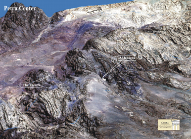
This digital elevation model shows the topographic relief around Petra and the
position of two major sites, the Treasury (Al Khazneh) at the end of the Siq
and the Roman-Greek amphitheater (The Theater), about a mile away. The city
of Petra extends onto the floodplain in the upper left. Image by T. Nirundorn,
courtesy of Cultural Site Research and Management.
Beginning in the 1990s, a team of archeologists from Brown
University, led by Martha Sharp Joukowsky, uncovered a civic complex with
a garden and central pool at the heart of Petra. The complex anchors the end
of the town’s main street, which roughly bisects the valley between Petra’s
monument-carved cliffs. The street itself follows an old ephemeral stream floodplain,
or wadi.
The Nabataeans prevented floods from destroying the city through a damming system
that diverted water from the wadi. They also lined the Siq — a gorge or
narrow chasm that leads from the outside desert to the entrance of the old city
and one of Petra’s largest monuments, known as the Treasury — with
water channels. This system of channels and dams controlled water flow and erosion,
and provided irrigation water to the settlement.
In addition to archeological investigations, satellite imagery is revealing
just how sophisticated the Nabataeans were “in terms of sculpting the ground
and the rock face to facilitate the natural flow of rainwater. That’s the
way they could keep erosion minimized,” Markoe says. “It’s the
breakdown of that system over the past centuries that is contributing to the
environmental hazard.” Sand deposits and rocks carried by flash flooding
now bury the courtyard and steps that once led up to the imposing facade of
the Treasury, Markoe says — piled more than 20 feet thick, “dramatic
evidence of how quickly flash flooding can devastate the site,” he says.
Nature at work
Petra sits on the western edge of the Arabian plate, southeast of the Dead Sea;
the sandstone outcrops extend north on the eastern side of the transform fault
segment of the Dead Sea rift zone (the fault zone becomes a spreading rift farther
south). An earthquake timeline from the AMNH/Cincinnati Art Museum exhibition
lists around 20 major seismic events in the greater region.
Fallen stone columns that lined Petra’s main street tell the story of the
earthquake and aftershocks that overwhelmed the city in A.D. 363, also described
in papyrus documents written to a Byzantine bishop. Approximately 800 carved
cliff monuments survived, but the living city of Petra died — trade routes
had shifted sometime in the previous century, and historians conjecture that
the community lacked the wealth to rebuild its central town structures after
the temblors.
Without any maintenance, Petra’s water system crumbled. The Nabataean dams
and canals no longer diverted water flow away from the tombs and town —
making the sandstone that composes most of Petra’s monuments and its Nabataean
Roman-style theater (which seats 12,000 to 15,000 people) once again susceptible
to accelerated weathering.
 Fractures across
the region, worsened by weathering and seismicity, collect water, which leads
to spalling — the freezing and thawing that widen cracks behind the rock
faces, eventually popping the outer layers off. Studies sponsored by the World
Heritage Center, part of the United Nations Educational, Scientific and Cultural
Organization (UNESCO), and which designated Petra as a World Heritage Site in
1985, showed that salt deposits from the irrigation systems and other water
table problems contributed to sandstone weathering and erosion. Ironically,
the flooding that created the region’s canyons now threatens to fill them
or erode away the human structures there. The shops that once lined the town
are now filled with flood deposits.
Fractures across
the region, worsened by weathering and seismicity, collect water, which leads
to spalling — the freezing and thawing that widen cracks behind the rock
faces, eventually popping the outer layers off. Studies sponsored by the World
Heritage Center, part of the United Nations Educational, Scientific and Cultural
Organization (UNESCO), and which designated Petra as a World Heritage Site in
1985, showed that salt deposits from the irrigation systems and other water
table problems contributed to sandstone weathering and erosion. Ironically,
the flooding that created the region’s canyons now threatens to fill them
or erode away the human structures there. The shops that once lined the town
are now filled with flood deposits.
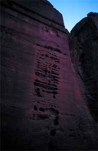
Water, wind and insolation have eroded
the walls of this tomb facade in the Outer Siq in Petra, creating a honeycombed
pattern of cavities called tafoni.
Conventional wisdom also holds that weathering in such dry places should be
greatest on southern rock faces, which get the most sun exposure, says Tom Paradise,
a geomorphologist from the University of Arkansas at Fayetteville, who has been
studying Petra for 20 years. However, in his studies there in the late 1980s
and mid-1990s, Paradise says, “what I found was that the greatest weathering
was on western faces, where you get wetting from storms, rain and sun.”
And Paradise found considerable weathering on eastern faces as well, where morning
dew and sun combined daily.
“It’s these little tiny super-frequent events, like wetting and drying
from dew every morning, that causes the sand to disaggregate,” he says.
Paradise documented the rates of weathering on rock faces all over Petra, meticulously
noting angle of the sun, precipitation at dawn, temperature, lithology and the
eroded spots in the monuments and elsewhere around the city — as well as
how fast such cavities grew over time. He calculated that some sandstones weathered
as much as 2.5 centimeters in 100 years.
Since then, Paradise says, he revisited his work on Petra’s Greco-Roman
theater, which he mapped with lasers for his dissertation in the late 1980s
to recreate its exact profile. A few years ago, while checking his work, he
found that the original stonemasons’ carved chisel marks — that had
remained plain on the rocks’ surfaces for centuries — had worn away
in some places. In just the few decades that Paradise has worked in Petra, he
says, millennia-old surfaces are gone. The puzzle he faced was why something
that had lasted so long could erode so quickly, when other conditions in the
region had not changed.
People at work
 While watching
tourists climb the stairs in Petra’s theater several years ago, Paradise
says he had an epiphany. “People don’t behave as well” as they
did several decades ago and during ancient times 2,000 years ago, he says. Hordes
of people now leave their marks on the cut-rock theater as “they climb
all over the seats.”
While watching
tourists climb the stairs in Petra’s theater several years ago, Paradise
says he had an epiphany. “People don’t behave as well” as they
did several decades ago and during ancient times 2,000 years ago, he says. Hordes
of people now leave their marks on the cut-rock theater as “they climb
all over the seats.”
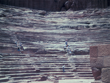
Petra’s Greek- and Roman-influenced
amphitheater holds seating for 15,000, but erosion from modern tourists scrambling
across the sandstone seats is accelerating as more people have come to visit
the ancient World Heritage Site.
Paradise also noted some seemingly simple shifts in human habits: “Tourists
are all wearing … the best shoes, with soles that grab on everything,”
he says, instead of the rubber-soled working boots or soft sneakers they wore
several decades ago. “We’re ignoring this huge factor and it’s
called us,” Paradise says.
As Paradise was observing these changes to his field site, the yearly number
of visitors was close to peaking. Since European explorers first documented
Petra in the 19th century, modern tourists have flocked to the site, which has
been labeled as the biblical city of Edom. Petra became a destination for busloads
of people ready to walk through the Siq, for religious tours, or to see theTreasury,
featured in the movie “Indiana Jones and the Last Crusade.”
The once relatively unknown city attracted at least half a million people in
2000, says Doug Comer, an archaeologist who runs a company called Cultural Site
Research and Management, in Baltimore, Md., which currently advises the organizations
that manage Petra. “That’s a lot of people in a site that 20 years
before was getting maybe 30,000,” he says.
The crowds of modern people visiting Petra have left many unexpected marks on
the ancient rocks, Paradise says, and they have accelerated the natural processes
at work. When Petra became a World Heritage Site in 1985, the Bedouin tribes
who had settled in the area were forced to leave the caves they had made home
(living in the monuments’ large rooms lined with rock-carved benches that
the Nabataeans had used as ritual banquet halls). But Bedouin people now run
tours of the site, bringing an influx of money to their community, according
to researchers who work there.
Paradise’s students monitored how people in those tour groups behaved,
from where they put their hands to where they placed their feet. The students
then looked at what had disappeared. “One whole chunk of wall of the Khazneh
[the Treasury] had lost sand because that’s where tour guides let people
sit” while they talked about the history of the site, Paradise says, leading
to a loss of half a cubic meter of sandstone over a few years.
Even the dark inner caves of the monuments carved by the Nabataeans and others
have suffered: “With more than 30 people entering the Khazneh, the humidity
jumped to levels that are unacceptable to preserve sandstone,” Paradise
says. Plus, the appearance of odd white deposits on the walls inside the Treasury
led Paradise to take a sample, assuming it was some kind of salt deposit growing
in flower-like structures on the surface. But, he says, lab tests showed the
deposits to be stearic acid — or beef fat, once a component of cheap suntan
oil in the Middle East. “People would rest by leaning against the wall
with sweating hands,” Paradise says, leaving a scum of fat behind. “This
is when you realize, ‘This is bad.’”
Paving the way
After September 11, 2001, “everything stopped,” Comer says. “Tourism
still hasn’t recovered in Petra.” This breather may be an opportunity
for establishing better management of the region, toward which Jordan’s
government and other organizations are working.
Needs as basic as adequate restroom facilities had been left unmet for years,
leaving tourists to use the tombs, Comer says. Medical services are unavailable
(heart attacks are a problem, owing to the average age of tourists, the heat
and the amount of walking necessary to see the site), he notes, and a lack of
personnel to guard the site makes theft of antiquities a constant concern. In
2001, Petra’s Jordanian caretakers closed the Treasury to visitors to control
humidity impacts, but people still sneak in, Paradise says.
Comer, who recently retired from leading the applied archaeology center for
the U.S. National Park Service, says that U.S. national parks protect a resource
“by steering people away from the sensitive parts,” and then educating
them in a separate space. Parks like Zion and the Grand Canyon are “like
Petra without the archaeology,” Comer says. Studies show that of the 5
million visitors that go to the Grand Canyon every year, the majority look at
it for about 20 minutes, but stay in the region for three days — impacting
the entire region on a greater scale. “Most don’t go into the canyon,
which is good, because if they did, it would be destroyed,” he says.
But guiding that experience in Petra remains challenging, Comer says. In Petra,
most tourists walk in, bring their own food, wander uncontrolled, and often
leave the same day on tour buses, without spending money in the region. That’s
something Comer and other parties involved would like to change, persuading
tourists to stay the night at local hotels and buy food locally.
In 1996, Comer led an analysis of how to manage and control all impacts to the
site, completing a report for the International Council on Monuments and Sites,
which is the cultural arm of UNESCO that advises the World Heritage Center.
In 2000, he and a group of advisors from the U.S. National Park Service, along
with Jordanian stakeholders, laid out the organizational structure necessary
to run Petra as a national park, “down to how many square meters of office
space they needed,” he says. In collaboration with the Jordanian Ministry
of Tourism and Antiquities, tourism groups, the Bedouins and nongovernmental
organizations, Comer and his team have moved forward to implement their management
plan.
Comer recruited four former U.S. National Park Service superintendents, including
the former head of Zion National Park in Utah, to work in Jordan with Petra’s
stakeholders. So far, the American team has worked out the relationships between
the different parties involved in running Petra, from park staff to independent
tour leaders to government agencies. But the advisory group is scheduled to
leave the region in June; Comer hopes that their tenure might be extended for
two more years.
For now, the restoration and conservation projects completed for the region,
listed by the Petra National Trust on its Web site, include rebuilt channels
that once carried water through the Siq. Future projects include such basics
as trail building and animal control measures, as well as an in-depth water
catchment study to determine fundamental information about how water moves through
the area. Comer’s company created digital elevation models in order to
determine the flood regime for the region. Future studies documenting weathering
and erosion will inform management of the site, Comer says. “The biggest
preservation problem is no doubt the tombs.”
Paradise says he intends to return in 2005 with his students to continue his
weathering research — and people-watching. “This is where I think
earth science has to go,” he says. “The only way to help things down
there is through good management.”
Preserving
an Afghan landmark
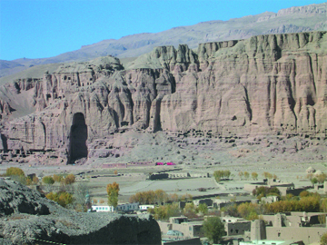 From
construction in the fourth to seventh century A.D. until just three years
ago, two giant Buddha statues resided about a quarter of a mile apart in
the Bamiyan Valley in central Afghanistan, marking the entrance to hundreds
of caves adorned with fresco art. The two statues, at about 180 and 125
feet tall, were the world’s largest standing Buddhas and among the
oldest such representations. But in March 2001, they met their demise at
the hands of the Taliban. Since then, people have been working to preserve
the cultural site and discussing whether or not to rebuild the statues. From
construction in the fourth to seventh century A.D. until just three years
ago, two giant Buddha statues resided about a quarter of a mile apart in
the Bamiyan Valley in central Afghanistan, marking the entrance to hundreds
of caves adorned with fresco art. The two statues, at about 180 and 125
feet tall, were the world’s largest standing Buddhas and among the
oldest such representations. But in March 2001, they met their demise at
the hands of the Taliban. Since then, people have been working to preserve
the cultural site and discussing whether or not to rebuild the statues.
Before its destruction by the Taliban in 2000, the larger of Afghanistan’s
two 1,800-year-old Buddha statues stood 180 feet tall. Now an empty niche,
the space that once held the large Buddha is still surrounded by 700 living
chambers and worship halls carved into the sandstone cliffs lining Afghanistan’s
Bamiyan Valley. Courtesy of Michael Urbat, University of Cologne, Germany.
From at least 300 B.C., central Afghanistan marked the confluence of ancient
civilizations in China, India, Rome, Greece and Persia. Merchants, artisans,
explorers and Buddhist monks traveling the famed Silk Road all passed through
Bamiyan, an oasis between two mountain ranges. Settling there, Buddhist
monks carved 700 living chambers and temples deep inside the valley’s
soft red sandstone cliff over the following several centuries.
Together with Greek artisans, the monks later decorated the chamber walls
with ornate and colorful frescoes. They also began carving the Buddha statues
directly out of the cliffs in huge niches, and carved staircases leading
up to the top of the statues’ heads. By covering the carvings with
mud and straw, the workers were able to fashion minute details such as facial
expressions and folds of clothing. They then plastered the entire statues
to preserve the detailing, and finally painted the Buddhas and gilded them
with gold.
The statues survived in the Bamiyan Valley more than a thousand years, through
conquering hordes, complete abandonment, strong earthquakes, desert weathering,
water intrusion and civil wars. But in 2001, after announcing its plan to
eradicate anything deemed idolatrous or that represented non-Islamic ideals,
the Taliban ignored pleas from the United Nations and countries around the
world, and destroyed the statues with dynamite.
Classified as a World Heritage Site in 2003, the entire Bamiyan site is
now in further danger. The Bamiyan cliffs are composed of a sequence of
conglomerates interbedded with fine-grained layers. And these same soft
Miocene sediments that allowed the artisans to carve the caves and Buddhas
now threaten the stability of the cliffs, especially after the 2001 explosions,
says Michael Urbat, a geologist at the University of Cologne in Germany.
Shoring up the collapsing niches that the Buddhas had occupied and the unstable
cliffs is the first priority for the United Nations Educational, Scientific
and Cultural Organization (UNESCO), says Christian Manhart, the organization’s
Afghanistan specialist. UNESCO has planned preservation efforts to prevent
further deterioration of the few frescoes still in the caves and potential
looting of the Buddha and fresco remains. He says 26 caves with paintings
remain, as well as fragments of the stone Buddhas up to 2 to 3 meters in
size. And though they are hardly visible, parts of the Buddhas’ shoulders
and arms also remain intact in the niches. “We need to save what is
there,” Manhart emphasizes.
Stabilization of the cliffs began last year, Manhart says. Commissioned
by UNESCO, an Italian engineering firm has been filling cracks in the Buddha
niches as well as anchoring very loose parts of the cliffs to the ground.
The firm has also been stabilizing the staircases and began securing the
back walls of the niches in April.
At the same time, other groups are moving forward with reconstruction efforts.
Using pictures of the Buddhas, Armin Gruen, a photogrammetrist from the
Institute of Geodesy and Photogrammetry in Switzerland who is working with
New 7 Wonders Society and the Afghanistan Museum in Switzerland, created
a 3-D computer model of the larger Buddha that is “as complete and
precise as possible for physical reconstruction,” he says. His next
step is to create structural models at different scales based on the 3-D
computer model.
Urbat and colleague Klaus Krumsiek are also working on reconstructions,
but reassembling the remaining fragments from a geological perspective.
“We figured that only a method based on geological criteria is suitable
to reconstruct the original position of blasted rock fragments,” Urbat
says. The basic idea, he explains, is to use paleomagnetic indicators to
match patterns on the back wall of the niche to any patterns on the remaining
Buddha rock fragments. At the request of UNESCO, Urbat visited Bamiyan in
2003 to test his method and found that he could indeed match the rock fragments
to locations in the niches, which could help in reassembly efforts.
Debate continues as to how exactly to reconstruct the Buddha statues and
even if it is a good idea. Manhart says that no one has been granted permission
from the Afghan government to reconstruct the statues, and for now, “we
must prioritize resources on preserving what remains in Bamiyan.” He
says that he also worries that any reconstruction work might cause further
damage to the parts of the Buddhas that remain in the cliffs. For now, the
government of Bamiyan is providing armed guards at the cliffs to prevent
looting or destruction of what remains.
Megan Sever
Back to top |
Conservation
changes
Methods to preserve regional treasures have changed over the past century,
as archaeologists, geoscientists and historians recalibrate their thinking
about conservation and restoration.
In Italy, conservationists once peeled off the lichen growing on historic
buildings, says Tom Paradise, a geomorphologist at the University of Arkansas,
Fayetteville, who works on erosion in historic sites. But now, they recognize
that lichens in some settings act as a natural seal that can protect rocks
from erosion and weathering.
And in Petra, Paradise says, one proposed method in the past to preserve
the rock faces would have actually destroyed them if applied. Researchers
wanted to apply a type of silica gel to the rocks, which Paradise calls
“a pretty amazing product” for statues, which can be dipped into
the sealant and allowed to soak it up over days. “If it’s done
perfectly and every pore is sealed, it works great,” he says, “but
if it has one little crack in it, it concentrates moisture,” which
accelerates weathering in the long run and may cause spalling (where outer
rock layers peel after freezing and thawing).
Ideas on restoration, however, have changed most with regard to reconstruction
of sites, says Doug Comer, an archaeologist who worked for much of his career
for the U.S. National Park Service. At the turn of the century, in Turkey
and Greece, archaeologists who excavated sites restored them after finding
pieces and putting them back together “as best they knew how,”
Comer says, but their work was all “speculative.” Archaeologists
today might reconstruct the sites very differently, and they still would
only approximate how they first appeared to people living at the time.
And information can be lost when an archaeological site is changed: In Petra,
archaeologists have re-stacked the fallen columns that lined the main street
of the city of Petra, destroying evidence of the earthquake that initially
toppled them. Such “anastylosis” — or reconstruction of buildings
— is still common.
Alternatives are available, says Comer, who uses digital elevation models
and remote sensing to reconstruct archaeological sites. He says he can imagine
that scientists eventually will construct their own digital restorations,
perhaps visible only in a handheld virtual reality model that a tourist
would carry around a site. “It’s better to make an image that’s
speculative than a restoration that’s speculative,” he says. “It
costs less,” and, if the model is wrong, Comer adds, the impact is
“nothing like what you’re doing with bricks and mortar.”
NBL
To see a digital reconstruction of Petra’s
downtown temple, go to links below.
Back to top
|
Lubick is a staff writer
for Geotimes.
Links:
"Exploring
Petra: A Web Tour," Martha Joukowsky et al., Brown University
"The
Pool Complex of Petra," Leigh Ann Bedal, University of Pennsylvania
Cultural
Site Research and Management Web site
Tom
Paradise's Web site
AMNH
Web site for Petra exhibit
Petra
National Trust
Back to top
