Geophenomena
9/11 clears skies for climate
studies
Dangerous dust storms on the rise
9/11
clears skies for climate studies
For several
days following Sept. 11, 2001, planes were grounded throughout the United States.
Satellite images during that time period show crystal clear skies across the
contiguous United States. The clarity, researchers say, stemmed from the absence
of jet contrails, and studies during that time period partly confirm what scientists
have proposed over the past few decades: Contrails, a form of cirrus clouds,
can change climate on short and long time scales.
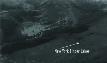
Skies over the Finger Lakes in upstate New York remained clear several days
after September 11, when planes were grounded in the United States. But Canadian
flights continued to make contrails that enhanced the cloudiness over Lake Erie,
as shown here in a satellite photo taken Sept. 15, 2001. NOAA-14 Polar Orbiter
AVHRR sensor.
The water droplets and ice that compose contrails condense in less humid conditions
than cirrus clouds do, partly because passing airplanes change the humidity
in their limited airspace, says Patrick Minnis, an atmospheric scientist at
NASA Langley Research Center in Hampton, Va. Contrails form and then disperse
to look almost exactly like cirrus clouds, Minnis says, which is “part
of the big confusion — it only takes an hour or hour and a half” to
disperse, depending on atmospheric conditions. “It’s a hard signal
to ferret out.”
The temporary blank slate in the United States’ sky, however, provided
an opportunity to contrail researchers to examine exactly how contrails form
and disperse. The only contrails to cloud the sky during the few days when jets
were grounded came from half a dozen military planes that flew over the Eastern
seaboard. Minnis and his co-workers tracked them to see how they spread, presenting
their results at a 2002 meeting of the American Meteorological Society and incorporating
the data into models.
The empty skies also allowed David Travis of the University of Wisconsin-Whitewater
and his co-workers to determine how contrails might be changing local temperature.
Their results, first published in
Nature in August 2002 and further elucidated
last March in the
Journal of Climate, showed that during the days when
jets were grounded in September 2001, sunshine increased the temperature at
ground level instead of being reflected by contrails. At night, the researchers
found, the absence of an insulating layer of contrails meant greater ground
level cooling.
“Suddenly, almost like magic, for the three days following September 11
we had a sudden clearing and temperature variations that were larger than normal,”
Travis says. The team found the largest three-day change in any September over
the past three decades, with an increased daily shift of an extra 1 degree Celsius
on average under the temporarily clear skies. Regionally, the daily temperature
swings over those three days were greatest in places that usually had the most
cloud cover in fall, such as the Midwest.
On a global scale, Minnis’ team reported in the April
Journal of Climate
that from 1971 to 1995, cirrus coverage increased over the northern oceans,
the United States and Western Europe, matching growth in air traffic over those
regions. Eastern Asia also saw an increase. Humidity measurements incorporated
into the study, Minnis says, indicate where contrails (and cirrus) were likely
to form. The team modeled cirrus cloud effects on climate, showing regional
temperature increases of about half a degree Celsius.
For now, researchers agree, contrails remain a regional climate problem. But
the Intergovernmental Panel on Climate Change estimates global demand for air
travel will increase nearly tenfold by 2050. Regions that don’t see many
contrails from jet flights now, such as Africa and elsewhere, should expect
to see them soon. For the three global regions that currently have high air
traffic, local climate is affected by both greenhouse gases and jet contrails,
Travis says. “I can see [that] down the road for the rest of the world,
it could be a double-barrel problem.”
When it comes to human impacts on climate, Minnis says, “contrails are
one of the most visible.”
Naomi Lubick
Dangerous
dust storms on the rise
The dust and
sand storms that have plagued Asia for millennia are becoming more frequent
and intense, with some areas experiencing a fivefold increase in the last 50
years. The economic and human health costs associated with them will also rise
unless governments join together to combat desertification, Korean and Chinese
scientists told attendees of the 8th Special Session of the Governing Council
of the United Nations Environment Programme (UNEP) in Jeju, Korea, last March
2004.
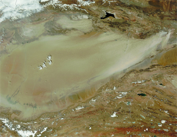
The Terra satellite captured this image of a dust storm over the Taklimakan
Desert, in western China on April 7, 2004. Scientists say that dust storms are
becoming more common in Asia, with increased pollution and desertification.
NASA/Modis Rapid Response System.
The storms originate in arid regions of northern China and Mongolia and blow
across the Korean peninsula, where they are called Asian Dust, and Japan, where
they are called Yellow Sand. The dust sometimes crosses the Pacific Ocean, reaching
North America, and occasionally travels as far east as Cape Cod.
The dust afflicts humans with respiratory problems, disrupts communication and
transportation, and causes the loss of crops, livestock and human life. A May
1993 dust storm killed 85 people in western China, causing damage worth 550
million yuan (US$95 million in 1993). And in March 2002, a storm dumped more
than 40,000 tons of sand per hour on the Korean peninsula, where the economic
damage from storms that month alone exceeded 6 trillion won (about US$5 billion).
Although dust and sand storms are the result of natural processes, the factors
fueling their increasing size, intensity, frequency and health effects may not
be, according to Youngsin Chun, a researcher at the Meteorological Research
Institute of the Korea Meteorological Administration in Seoul, South Korea.
Each spring, a number of elements combine to cause the storms, including strong
winds, dry friable soil and unstable atmospheric conditions. Strong winds related
to the Siberian High, a cold air mass that sweeps across Asia each spring, provide
the energy to raise fine, dry soil into the air. There, it is held in long-term
suspension by an unstable air layer that results from uneven heating of the
ground and air. “Solar energy heats the soil surface very well, but the
air is relatively cool,” Chun explains. “This results in the turbulent
air motion needed for the suspension.”
According to UNEP, global warming, pollution and increased desertification,
resulting from poor land management practices and population growth, are making
the phenomena worse. In China, where 30 percent of the land surface is affected,
desertification costs $6.5 billion each year, and the problem is spreading.
Between 1994 and 1999, the Gobi Desert, one of the main sources of dust storm
sand, grew by 52,400 square kilometers due to farming, grazing and deforestation.
And that trend will likely continue, says Lance Leslie, a meteorologist at the
University of Oklahoma. “The arid desert regions of the world in general
are expected to become drier, thereby in most cases, increasing the chances
for dust-storms,” Leslie says.
The effects from global warming are most pronounced in the winter, Chun says,
and warmer, drier winters can lead to dust storms in the spring. Also, as the
dust and sand bind with human-made air pollutants, such as soot, she says, they
are becoming even more of a human health hazard.
At the Jeju conference, Klaus Toepfer, executive director of the UNEP, said
that the program has begun assisting the governments of Northeast Asia through
a joint project to develop a network of monitoring stations and early warning
systems. Although short-term warnings are imperative for emergency management,
long-term forecasts can give those in the path of a dust storm a greater opportunity
to prevent loss of life and property.
Predictive models are currently in routine use in China, and in experimental
use in several other countries, says Leslie, who has co-developed a numerical
predictive model for dust storms. “Our predictive system, among others,
is used for multi-week predictions and even seasonal predictions of conditions
conducive to dust-storm development,” Leslie says. These models take into
account several complex factors, including surface-vegetation cover and land-surface
types, as well as soil type, texture and moisture.
Chun stresses that any long-term solution will have to involve all the countries
of Northeast Asia working together to moderate the human factors that influence
the storms.
Sara Pratt
Geotimes contributing writer
Back to top