
 Volcanologists
lead exciting and decidedly risky lives — often ascending the slopes of
erupting volcanoes to install sensitive monitoring equipment and then hiking
back up there a few days later to collect the data — all to learn more
about the natural hazard and to prevent future loss of life. But it doesn’t
have to be this way.
Volcanologists
lead exciting and decidedly risky lives — often ascending the slopes of
erupting volcanoes to install sensitive monitoring equipment and then hiking
back up there a few days later to collect the data — all to learn more
about the natural hazard and to prevent future loss of life. But it doesn’t
have to be this way.
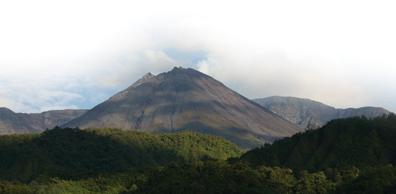
Deep in the jungles of Ecuador, Volcán Reventador has been actively erupting since 2004. Researchers recently outfitted the volcano with new “intelligent” mini-sensors to monitor its activity. All images are courtesy of Matt Welsh.
Imagine instead a system in which volcanologists fly over the volcano in helicopters, drop miniature sensors from above, then go back to a base a safe distance away from the eruption and watch, as sensors communicate about the happenings deep inside the volcano. Such a system is not too far off, says a team of volcanologists and computer scientists.
A couple of years ago, Matt Welsh, a computer scientist at Harvard University in Cambridge, Mass., developed small wireless sensors and was working on finding applications for them. One such application was the use of the instruments to measure temperatures and rainfall in remote forests. The medical industry was also quite interested, he says, as medics could place the sensors — smaller than the palm of a hand — directly on patients to read vital signs in real-time from anywhere in the hospital via a PDA or other computer system.
Then one day, Welsh says, a computer science graduate student suggested that the wireless sensors might be applicable to volcano monitoring. The graduate student had previously worked with Jonathan Lees, a volcanologist at the University of North Carolina in Chapel Hill, who was working on ways to make volcano monitoring easier and less dangerous. “We don’t court danger, per se, but we’ll go as close as we have to, to get the measurements we need,” Lees says. And getting there is half the battle, says geophysicist Jeff Johnson of the University of New Hampshire in Durham.
Traditional monitoring equipment, about the size of a suitcase with two car batteries that supply the power, is expensive, power-hungry, heavy and unwieldy, Johnson says, often involving vehicles or helicopters to deploy it. Additionally, in remote areas, such as the active volcanoes in the jungles of Ecuador and other locales that threaten increasingly larger populations, scientists have to drag much of the equipment in on their backs, hiking long distances through rough terrain to install and maintain the equipment. This unwield- iness, as well as high costs, limit where the equipment can be placed, and the number of systems that can be set up on one volcano.
To lighten their loads, Johnson, Lees and Welsh started working together with other computer scientists and volcanologists from their institutions, as well as the Instituto Geofisico in Quito, Ecuador, to create a system of wireless computers attached to lighter, cheaper volcano monitoring instruments. “I was skeptical” of the pairing at first, Welsh says, but “it turned out to be a great match.”
The new smaller, lighter, less-power-hungry system is reminiscent of traditional monitoring equipment, in that each station contains a seismometer, an acoustic microphone, a power source, and a way to collect and store the data. However, the data acquisition system is decidedly smaller. Rather than hefty car batteries, the new system relies on two D-cell batteries like what is used in some portable radios.
The system also collects and stores data differently. Traditionally, acoustic microphones “listen” for low rumblings from within the volcano and feed data to a hard drive or flash drive. Seismometers record earthquakes of all sizes to the same drives. And with many traditional systems, researchers have to return to the site and collect the data every so often. At some locations, such as Mount St. Helens in Washington, the data is relayed via radio telemetry directly to a nearby observatory.
Although the wireless sensor network that transmits the data directly back to the observatory is somewhat similar to the newly designed sensor, the traditional system relies on the observatory, while the new one is designed to function independently. “Traditionally, we focus on continuous streams of data coming at us — with no intelligence — which require a lot of power, bandwidth and data processing,” says Seth Moran, a volcano seismologist at the U.S. Geological Survey’s Cascades Volcano Observatory in Washington. “These new networkable sensors are intelligent, a different way of doing things,” he says. Rather than storing all data on a hard drive, this system selectively acquires data from an array of locations using processors that communicate via low-powered radio and antenna and GPS unit, Johnson says.
 An inexpensive
“interface board” collects data from the seismometer and microphone
at each station, then converts the data into a digital form, and sends it to
a small wireless live computer, known as a “TMote Sky,” or mote, Welsh
says. The mote has only 60 kilobytes of memory — a typical cell phone has
more memory — to keep the power consumption low, and the mote downloads
data “about 1,000 times slower than the average Wi-Fi connection at a Starbucks,”
he says.
An inexpensive
“interface board” collects data from the seismometer and microphone
at each station, then converts the data into a digital form, and sends it to
a small wireless live computer, known as a “TMote Sky,” or mote, Welsh
says. The mote has only 60 kilobytes of memory — a typical cell phone has
more memory — to keep the power consumption low, and the mote downloads
data “about 1,000 times slower than the average Wi-Fi connection at a Starbucks,”
he says.
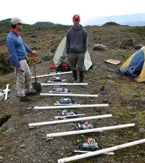
Volcanologists and computer scientists have teamed up to create new sensors that can communicate with other sensors on a volcano, testing it recently on Ecuador’s Volcán Reventador. The equipment is similar to traditional monitoring equipment, except much smaller and lighter.
But the system is “smart,” Lees says, as each station is able to independently choose which data to record and then communicate with other stations. When the seismometers or microphones pick up on activity, they “speak” to one another: If one seismometer “feels something interesting,” that station will ask its neighboring stations if their seismometers felt “the wiggle” too, Welsh says. If enough of the seismometers felt something, they’ll send that data to a “gateway computer” that will record it for the researchers, who are safely settled at a laptop several kilometers away.
This “intelligent” selectivity and communication eliminates the recording of, say, a cow stepping on one seismometer, Lees says. “If you have a whole network of these stations working together and communicating, it’s like a brain,” he says. The stations work as synapses, pulling together data and making an informed decision about how to react. By choosing the important things to record, the stations “can gather a lot more important information,” Moran says.
The new system costs a fraction of the traditional monitoring system, which can run anywhere from $5,000 for the most basic seismometer, to $25,000, Moran says. The new system, Lees says, costs somewhere around $500.
The stations also are small and light enough to fit in a person’s hand, Lees says. A researcher climbing the side of a volcano for deployment could carry six of these systems at once, he says.
Last summer, the team pilot tested their network on Volcán Reventador, deep in the Ecuadorian jungle about 100 kilometers from the capital, Quito. Reventador explosively erupted in 2002, sending pyroclastic flows careening down its slopes up to 8 kilometers away and ash flying 17 kilometers above the mountain, blanketing Quito with ash and causing schools and the airport to close. After a brief period of quiescence, it reawakened in November 2004 and has remained active since. The volcano’s eruptive behavior was relatively stable in 2005, with daily cone-building activity making it an ideal location to test their system, Johnson says.
The team installed 16 stations in a line down Reventador, each 200 to 400 meters from one another over a distance of 3 kilometers. They also installed three traditional equipment stations to offer a point of comparison in the data.
Over a period of 19 days, the network captured 230 separate volcanic events, including eruptions, earthquakes and tremors (longer periods of shaking). It collected data 61 percent of the time.
“There were many lessons learned,” Welsh says, “and a lot of bugs remain” in the software, such as calibrating the timing of all the motes, which “didn’t work well at all.” The timing presents numerous challenges, he says, but it is essential to understanding just what is happening in the belly of the volcano.
Another potential hurdle for the new system, Moran says, is making it able to withstand weather of any kind. Some monitoring instruments atop Mount St. Helens, for example, are buried under 30 feet of snow right now, he says. The new stations don’t have enough power or bandwidth to be able to transmit data under such conditions.
“Overcoming the power and bandwidth issues presents some pretty decent challenges,” he says. Indeed, “smart management of power is possibly the biggest challenge” the researchers face, says Sharon Kedar, a volcano seismologist at NASA’s Jet Propulsion Laboratory in Pasadena, Calif.
Kedar, who was not involved in the Reventador project, has been working with Lees to design a new deployment strategy that would enable the instruments to be dropped from helicopters. “We need rugged and fairly cheap impact protection for these instruments that can be deployed quickly and in hazardous environments,” Kedar says. So, they modeled several possibilities after what NASA scientists have been using for rovers and landers on Mars.
The impact protection, Kedar says, needs to ensure that the instrument survives the crash and once it hits the ground, it needs to be able to implant into the ground or something hard, so that the seismometer has a stable resting place. On a volcano, as well as on Mars, there is such a variety in the type of landing spot, from soft ash to hard bedrock, that the system has to be self-contained, he says. One such possibility is a foam that expands and hardens to encase the seismometer, Lees says, but this is all “very preliminary.”
The team is also working on a way to make the project more user-friendly. Ideally, the researchers would like to link the stations to a satellite, rather than just a laptop at an observatory several kilometers away, Johnson says. If a satellite transmitted data directly from the stations to the Web, then students and researchers, as well as emergency responders, could watch the volcano’s activity in real time from anywhere in the world.
“Currently, continuous telemetry options via satellite are prohibitively expensive,” Johnson says, so the team is again looking at ways to process the data on site and communicate or send back only the “really important data.” The team plans to deploy a satellite-based system by next spring on another active volcano in Ecuador.
“A high percentage of the world’s volcanoes near populated places aren’t monitored,” Kedar says, which leaves a lot of people in harm’s way. “It would be nice if we could avert a disaster instead of waiting for one” — whether that disaster be the loss of a volcanologist who is trying to figure out when a volcano is going to blow, or the loss of a city because an unmonitored volcano suddenly explodes.
Megan Sever
 |
Geotimes Home | AGI Home | Information Services | Geoscience Education | Public Policy | Programs | Publications | Careers |