


| |
|
|
|
|||||
| |
|
|
||||||
|
||||||||
GEOPHENOMENA WEB FEATURES:
|
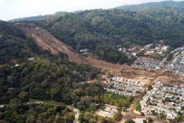
The Cocos and Caribbean plates played tug-of-war on Jan. 13 with El
Salvador on the rope. When the tension broke, the resulting magnitude-7.6
earthquake jolted the ground beneath Balsamo Ridge along the Pan American
Highway. Loosened debris flowed down the ridge taking parts of the forest
with it. At least 450 people were reported dead and 1,200 missing after
one landslide obliterated a section of the San Salvador suburb of Las Colinas.
Another landslide trapped and killed 10 people traveling by bus along the
Pan American Highway near San Vicente. Numerous other slides blocked rescue
efforts along the roads.
Almost a year earlier in Taiwan, a break in the Chelungpu fault created
a magnitude-7.6 earthquake that toppled buildings in Taipei, killing 1,800
people. Like the recent El Salvador earthquake, the Chi-Chi, Taiwan, quake
triggered landslides from the countrys topographical highs. Across the
Central Mountain Range of Taiwan, at least 7,000 landslides hit an area
of several thousand square kilometers. Twenty-nine of the 36 people living
under the fall zone of one rock avalanche in Tsaoling died and more than
20 people died from a landslide in Jiu-Feng-Erh-Shan, according to U.S.
Geological Survey (USGS) reports.
[At right: The Jan. 13 earthquake
that hit El Salvador triggered this landslide from the Balsamo Ridge over
Las Colinas. Edwin Harp.]
Both earthquakes induced landslides that were inevitable. In those
cases where you have tectonically very active areas, high steeped slopes
and deeply weathered material you are going to have earthquake triggered
landslides on a frequent basis, says Randall Jibson of the USGS.
The landslide that buried Las Colinas did not occur, as some environmental
groups asserted, because of deforestation. Tropical flora on the ridge
could not have stopped the approximately 500,000 cubic meters of earth
that inundated Las Colinas. Forest shade trees typically have shallow roots,
about 50 inches deep, that grow where oxygen is plentiful. The quake shook
free a precarious layer of volcanic deposits reaching 50 to 70 feet in
depth. It probably failed due to liquefaction in ash deposits near its
basal shear surface, says Ed Harp of the USGS, who visited the area after
the earthquake.
Before the earthquake struck, Holocene ash-fall deposits at the base
of the Las Colinas landslide had probably collected some water, enough
to liquefy the land when the shaking started, Harp says. Underlying these
deposits is an ancient, impermeable soil layer that acts as an aquiclude,
holding the water and creating a perched water table sitting within the
ash above. In such a situation, the ash deposit can liquefy during seismic
shaking while much of the overlying deposits remain dry. In fact, Harp
observed that the tip of the landslides tongue was wet and soupy, while
landslide material from the top of the ridge was dry.
Past volcanic eruptions had left angular shards of ash and glass strewn
across the top of Balsamo Ridge, creating deposits about 25 meters thick
of andesitic cinders and some interbedded rhyolitic tephra. Two kilometers
west of Las Colinas is another housing development, Pinare de Suiza, that
is built even closer to the ridge, Harp says. A spider web of cracks along
the ridge crest outlines potential slides that may fail in the future.
Come the rainy season Id be surprised if we didnt have more landslides,
Harp says.
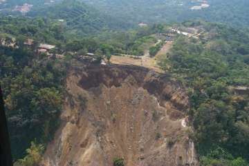
[At left: Head scarp from
the Los Colinas landslide. Edwin Harp.]
In Taiwan, the landslides that followed the September 1999 earthquake
were shallow and fast, wrote Hsi-Ping Liu and colleagues in a USGS report.
Valley-cut steep slopes and other highway cuts through the Central Range
were hit the most. Uplifted, folded and faulted sandstone, siltstone, shale
and weakly cemented Pleistocene conglomerate litter the mountain front
and western part of the Central Range. The landslide in Jiu-Feng-Erh-Shan
brought an estimated 72 to 90 million cubic meters of rock and soil from
the slopes. In Tsaoling as much as 140 million cubic meters fell into a
valley cut by the Ching-Shui River. A significant amount of landslide
material moved across the river and some distance up the opposite bank,
the report says.
Three months after the earthquake, the dam from the Tsaoling landslide
had created a popular tourist attraction. A sizable lake had built up
behind the landslide dam and they had concessions running boat trips out
on the lake for sightseeing and fishing, says David Keefer of the USGS.
In the past, at least two other landslides are thought to have dammed the
river: one possibly in 1862 that breached in 1898, and another in 1941
that lasted 10 years until the lake overtopped the dam in a flood.
In November 2000, Clarence Duster of the U.S. Bureau of Reclamation
visited Taiwan and learned from the Water Conservancy Agency that to protect
the dam in Tsaoling, the agency had built a channel through the top of
the dam and lowered a portion of the reservoir. The channel was trickling
out a flow of a few cubic meters per second. Is the dam at risk from another
flood? Theres always that possibility, Duster says. For now, Tsaoling
has a lake.
In El Salvador, loose earth is still hanging from the edge of the hilltop
above Santa Tecla. Ed Harp told Salvadorian President Francisco Flores
that hazards from additional landslides would present a risk to the residents
of Santa Tecla if another large earthquake approaching a magnitude of 7.0
hit.
In the absence of such an earthquake, aftershock- and rainfall-triggered
landslides will probably be relatively small and not present a high hazard
to people living in the city below the ridge, he said. However, even if
no large earthquake occurs in the near future, 15 to 20 years from now
there could be another large earthquake and accompanying landslide similar
to the Las Colinas landslide triggered from Balsamo Ridge.
Christina Reed
 |
Geotimes Home | AGI Home | Information Services | Geoscience Education | Public Policy | Programs | Publications | Careers |