


| |
|
|
|
|||||
| |
|
|
||||||
|
||||||||
With earthquake damage to property in California estimated to cost $3.9 billion a year over the next few decades, seismologists are targeting areas of greatest risk. Part of their effort is educating the public on why understanding the geology under a building could make the difference between eating seismic surf or riding the waves out.
 The
Mines and Geology Division of Californias Department of Conservation,
which in September released its calculation of the future cost of earthquakes,
has been systematically mapping California in 60-square-mile sections.
The maps show where landslide zones and water-saturated, sandy soils
soft soils known to undergo liquefaction when shaken are a threat. The
seismic hazard maps cover more than 120 cities, including communities in
Orange, Los Angeles, Santa Clara, San Francisco, Ventura, and Alameda counties.
The
Mines and Geology Division of Californias Department of Conservation,
which in September released its calculation of the future cost of earthquakes,
has been systematically mapping California in 60-square-mile sections.
The maps show where landslide zones and water-saturated, sandy soils
soft soils known to undergo liquefaction when shaken are a threat. The
seismic hazard maps cover more than 120 cities, including communities in
Orange, Los Angeles, Santa Clara, San Francisco, Ventura, and Alameda counties.
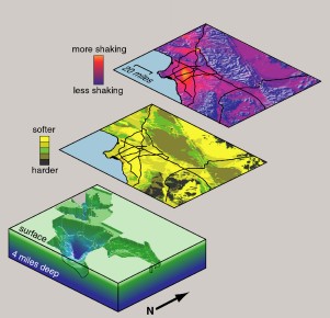
[Two important geologic factors that affect the level of shaking experienced in earthquakes are (1) the softness of the surface rocks and (2) the thickness of surface sediments. In these images of the Los Angeles Basin, the lowest layer shows the depth of sedimentary basins and the middle layer shows the softness of near-surface rocks and sediments. The top layer combines this information to predict the total amplification expected in future earthquakes. The orange areas are the hot spots where this amplification is anticipated to be highest. Courtesy of the Southern California Earthquake Center.]
Taking the maps one step further, the Southern California Earthquake Center (SCEC) of the University of Southern California recently published a study identifying hot spots where these soft soils might shake the most.
Los Angeles, one of the hot spots, sits on a virtual bowl of Jell-O. The deeper the sediments, the higher the relative amplification of the shaking during an earthquake. We compared where the sediments are very shallow with where the basin is very deep and found the amplification can go up by a factor of two, says SCEC director Tom Henyey. Beneath downtown Los Angeles, the siliceous shale reaches a depth of four miles. On the flanks of the basin, sediment depths peter out toward the mountains.
But the risk to residents depends on where an earthquake strikes. Because we dont know where the next earthquake is going to be, we had to do an average, Henyey says. The study used computer predictions of earthquakes, based on past fault behavior, and the geologic idiosyncrasies of local sites to quantify the extreme hazard areas. The researchers keyed in on two important factors: a soils ability to transmit shear waves, which measures its softness level, and the depth of the sediments above hard bedrock.
The SCEC study follows an earlier analysis of earthquake probabilities throughout California. The next phase will combine the amplification predictions with models of earthquake probabilities. The hot spot in Los Angeles extends in a trough-like fashion from near the Coliseum Complex down toward Anaheim, Henyey says. Other watch zones include a section of the north end of the San Fernando Valley, where soft soils might be deeper than soils beneath Los Angeles.
For some in the field the report is reassuring. They took conventional wisdom theories in seismology and put some meat on them, says Arthur L. Lerner-Lam, associate director for geophysics and geology at Columbia Universitys Lamont-Doherty Earth Observatory. In the long run it pays to have a general idea of what the shallow structure will do to amplify ground motion and so this is a useful study, he says. But its greatest impact will be in public awareness.
Seven years ago, on Jan. 17, 1994, the magnitude-6.7 Northridge quake claimed the lives of 57 people and caused more than $20 billion in damage. In the early morning hours, the temblor crumbled houses and apartment buildings and cracked apart a section of the Santa Monica Freeway and the Antelope Valley Freeway overpass. Deep sediment exacerbated the shaking damage in Santa Monica while denser, shallow sediment left freeways and homes closer to the epicenter unscathed.
The SCEC report appeared in a special issue of the Bulletin of the Seismological Society of America published Jan. 28, and is part of a multiphase study with the long-term goal of identifying every hot spot associated with a potential earthquake. Large basins and valleys are generally most susceptible. Public officials may find the report useful for determining where structures would benefit from retrofitting, Henyey says. If youre sitting in the middle of a basin or youre sitting on certain kinds of soft soils you may want to think about doing additional engineering design to improve the structures performance in earthquakes.
Christina Reed
 |
Geotimes Home | AGI Home | Information Services | Geoscience Education | Public Policy | Programs | Publications | Careers |