Geotimes

Web
Feature
In Search
of Water: An
Update on Yucca Mountain Studies
Russ Dyer,
Abe Van Luik, Ron Linden and Rick Salness
 Design
and fabricate a system that will last thousands of years longer than the
recorded history of humankind. Make that system robust enough to isolate
highly radioactive material so that it will not threaten human health and
the environment for millennia.
Design
and fabricate a system that will last thousands of years longer than the
recorded history of humankind. Make that system robust enough to isolate
highly radioactive material so that it will not threaten human health and
the environment for millennia.
Unprecedented challenge or
daily task? Both the system is Yucca Mountain, the federal governments
candidate site for the disposal of high-level radioactive waste and spent
nuclear fuel. The Department of Energy (DOE) Yucca Mountain Site Characterization
Offices mission is to provide the basis for a national decision regarding
the development of a repository for spent nuclear fuel and high-level waste
at Yucca Mountain. The natural and engineered features are expected to
work together to isolate the wastes from the public and the environment
for more than 10,000 years, as required by law.
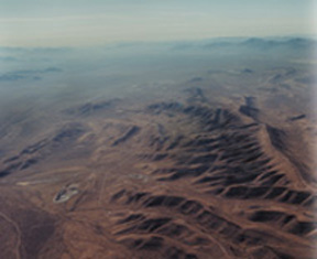
Yucca Mountain lies in Nye County,
Nev., about 100 miles from Las Vegas. Since 1982, the Department of Energy has
been working to determine its suitability as a site for storing high-level nuclear
waste. On Feb. 15. President Bush approved Yucca Mountain as a nuclear disposal
site. Image courtesy of the Department of Energy.
Congress charged DOE (in the Nuclear
Waste Policy Act of 1982 as amended) with this task almost 20 years ago. Now,
completion is years away, but on Feb. 15, President Bush approved Yucca Mountain
as the nation's geologic repository. In January, the Secretary of Energy notified
the Nevada Governor that he intended to recommend to the president that the
site be developed as a repository. The final decision in this complex process
could make the site the nations first deep geologic, high-level radioactive
waste repository.
The geology of Yucca Mountain
is critical to containing the radioactivity present in spent nuclear fuel
and high-level radioactive waste. Water in the geologic setting is the
primary medium by which radioactivity could escape.
The requirements to limit
the release of radioactivity to the accessible environment are spelled
out in regulations and guidelines set forth by the U.S. Environmental Protection
Agency, the U.S. Nuclear Regulatory Commission and DOE. Preliminary performance
estimates for the expected evolution of the system indicate that the mountain
itself (the natural system) is capable of isolating over 99 percent of
the radionuclides that would be placed in the repository. The disposal
cask, or waste package, and the rest of the engineered system provide for
the remaining 1 percent. Defense in depth also assures compliance.
These regulations require
that we evaluate the expected and the unexpected geologic evolution of
the system. Expected events include seismic activity that would cause rock
falls in the repositorys drifts, or storage tunnels, with minor consequences.
An example of something unexpected would be a volcanic event, such as a
dike intersecting the repository, which has a mean likelihood of occurrence
of approximately one chance in 62 million per year. Such an event is evaluated
in terms of potential consequences. The regulations require that these
consequences, multiplied by their likelihood, be below a specified target
value. Evaluations performed to date suggest it is highly likely that a
repository at Yucca Mountain would be able to meet the specified safety
target for both its expected and unexpected evolution scenarios.
The expected evolution of
the repository system at Yucca Mountain will rely on two geologic barriers:
the volcanic rock above the water table, called the unsaturated zone barrier;
and the volcanic rock and alluvium below the water table, called the saturated
zone barrier.
Unsaturated zone
The host rock (welded tuff)
that defines the repository horizon is in the unsaturated zone, approximately
1,000 feet below the crest of Yucca Mountain and approximately 1,000 feet
above the water table. The thickness of the unsaturated zone provides a
significant barrier to long-term rises in the water table induced by climate
change or transient seismic activity. The repository would reside within
this unsaturated zone where the waste packages would be placed in tunnels
called emplacement drifts and excavated within layers of the unsaturated
welded tuff.
Yucca Mountain is an uplifted
ridge of alternating layers of welded and non-welded silicic volcanic tuffs
of Miocene age. The degree of welding of the various tuff units determines
how water moves through each particular unit. Generally, water predominantly
flows through fractures in the welded units, while it tends to flow through
the matrix of the non-welded units.
On the most fundamental level,
the factors affecting unsaturated groundwater flow at Yucca Mountain are
the climate and the hydrologic properties of the rocks. Derived from these
two basic factors are estimates of two key unsaturated zone processes:
deep percolation flux and potential seepage into waste emplacement drifts.
Temperature also plays a
part. The conditions within the drift environment and the potential transport
of radionuclides from the repository horizon must be considered for both
ambient and thermally affected scenarios. Specifically, the heat given
off by the decay of the spent fuel will raise the temperature of the repository
environment and will affect the ambient flow field in various hydrologic,
chemical, and mechanical ways.
The Unsaturated Zone Flow,
Transport, and Coupled Processes Model is the tool for investigating the
wide range of processes that can affect the natural system of the repository.
This overarching model integrates a number of separate modeling efforts
that address a variety of physical, hydrologic, thermal and chemical phenomena.
These sub-models include a geologic framework model; models for climate
and infiltration; unsaturated zone flow; drift seepage; radionuclide transport;
a mountain-scale model of thermal-hydrologic, thermal-hydrologic-mechanical,
and thermal-hydrologic-chemical interactions; and a drift-scale model of
thermal-hydrologic and thermal-hydrologic-chemical interactions.
Sub-models are abstractions
of reality. Each one differs in complexity, depending on its impact or
on its associated uncertainty about overall system performance. Sub-models
are working hypotheses, which are consistent with existing knowledge, but
which scientists are continually re-evaluationg for adequacy over time
as new knowledge becomes available.
Inputs for these models come
from many sources: geologic and fracture maps (made from boreholes, drifts
and outcrops); climate records and infiltration measurements; in-situ hydrologic
measurements (air permeability, fracture porosity, saturation and water
potential); laboratory hydrologic measurements (matrix permeability, porosity
and capillary pressure); tests for seepage, flow and transport; thermal
testing; and geochemical, isotopic and mineralogical measurements.
Subsurface testing continues
within several alcoves and niches of the Exploratory Studies Facility (ESF)
and Cross Drift to gather additional data to refine the drift seepage model.
Niches are short drifts, typically 10 meters long, that branch off the
ESF or Cross Drift and are used for testing whether emplacement drifts
can effectively contribute to limiting potential drift seepage. The capillary
barrier mechanism and the seepage threshold concept the amount of percolation
flux below which no seepage into a drift occurs have been investigated.
DOE is adopting a conservative approach to manage the uncertainty inherent
in the natural systems behavior.
DOE is collecting additional
data relevant to seepage modeling with regard to spatial and temporal flow
focusing, the zone disturbed by excavation, drift geometry and drift surface
effects, ventilation and evaporation-condensation effects, and thermal
effects and coupled processes.
The engineered barrier system
incorporates a component designed to add an additional layer of safety
for the waste packages. This barrier is a drip shield composed of titanium.
It will extend over the waste packages and block any seepage. The barrier
system will also provide protection for the waste packages from rock falls
produced by drift degradation.
A large-scale experiment
to monitor moisture is underway within the Cross Drift. The last third
of the Cross Drift has been sealed for nearly three years, with the exception
of periodic entries to observe and collect potential seepage below the
crest of Yucca Mountain and under the hill slope associated with the Solitario
Canyon fault, host to suspected zones of high infiltration. The objective
of this effort is to see if any seepage is observed under ambient (unventilated)
conditions. To date, no confirmed seepage has been observed. All water
samples collected have been shown to exhibit a chemical composition consistent
with water condensing due to temperature gradients resulting from machinery
heat sources.
Other ongoing studies are
providing valuable data for systematic hydrologic characterization of potential
repository host rocks, the diffusive properties of faults in response to
various tracers, and estimates of seepage potential using calcite abundances.
Also ongoing are corroborative studies of bomb-pulse isotopes (chlorine-36
and tritium), pore water chemistry, fluid inclusions and oxygen isotopes,
unsaturated zone transport, and natural analogs.
The testing program for unsaturated
zone flow and transport continues to update the information needed for
better calibration, validation and assessment of models showing how water
flows and how radionuclides may be transported through the unsaturated
zone. We are refining and improving our understanding of the unsaturated
zone attributes that contribute to the waste isolation capacity of Yucca
Mountain in order to achieve more realistic representations of the unsaturated
zone system with drift-scale to site-scale models.
The new information strengthens
the effort to determine whether the water potentially seeping into the
drifts is limited in amount and whether the modeled concentrations of radionuclides
moving through the volcanic tuff below the repository can be more accurately
calculated. With limited seepage and, subsequently, reduced radionuclide
concentrations capable of being transported, the unsaturated zone could
be a more effective barrier than our initial, conservative modeling approach
suggests.
Although not all testing
of the site has been completed, the wide range of studies to date generally
indicate that the combined attributes of the natural system plus various
engineering design enhancements can successfully provide a suitable environment
for the safe emplacement and isolation of waste.
Saturated
zone
Assessing the performance
of the total repository system includes evaluating the potential for radionuclides
to migrate through the saturated zone underlying Yucca Mountain and from
there migrating into the accessible environment. While the host rock of
the unsaturated zone offers essential protection to preclude transport
of radionuclides to the accessible environment, the radionuclides would
first have to pass through the waste package and engineered barriers. Radionuclides
cannot escape the repository until the waste package and waste form deteriorates.
Only then could they start their vertical movement from the unsaturated
zone and down into the water table and saturated zone.
The saturated zone at Yucca
Mountain is another component of the natural barrier system affecting the
transport of radionuclides to the biosphere. Evaluations of the zones
long-term behavior take into account the effects of climate changes, with
water table rise and increased flux being the saturated systems response
to a wetter climate.
The physical processes relevant
to groundwater flow and radionuclide transport in the saturated zone are
advection, dispersion, sorption, matrix diffusion, colloid-facilitated
transport, and radioactive decay and the ingrowth of decay products.
Groundwater flow in the saturated
zone at Yucca Mountain initiates in volcanic tuffs and transitions into
alluvium. Physical processes in the volcanic aquifer and the alluvial aquifer
have different effects on the fate and transport of radionuclides. The
volcanic sequence is dominated by fractured media, and the groundwater
mainly travels through these fractures. Physical transport properties in
the volcanic media involve advection and matrix diffusion. Sorption can
occur on fracture coatings and on the rock matrix.
The alluvial aquifer system
is currently modeled as if it were a single porosity continuum. This continuum
has a larger effective porosity than the volcanic system, which means the
models show the groundwater traveling more slowly through it. Testing is
in progress that will either support the current modeling or allow more
realistic modeling of groundwater paths through the saturated zone. Transport
properties important to the alluvial system are advection, dispersion,
and sorption.
 The
Yucca Mountain Project hydraulic and tracer testing programs test conceptual
models of flow and transport in the volcanic and alluvial aquifers and
obtain flow and transport properties of the media. The C-Wells complex
was developed for testing in the volcanic system. Testing at the C-Wells
complex was completed in 1999. The alluvial testing complex (ATC) was developed
for testing the alluvial flow system. Single well tests were completed
in 2000, while multi-well testing was initiated in 2001 and is continuing
to date.
The
Yucca Mountain Project hydraulic and tracer testing programs test conceptual
models of flow and transport in the volcanic and alluvial aquifers and
obtain flow and transport properties of the media. The C-Wells complex
was developed for testing in the volcanic system. Testing at the C-Wells
complex was completed in 1999. The alluvial testing complex (ATC) was developed
for testing the alluvial flow system. Single well tests were completed
in 2000, while multi-well testing was initiated in 2001 and is continuing
to date.
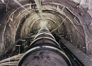
The Heat Test Drift. Each
drift will store containers of nuclear waste. Image courtesy of the Department
of Energy.
The C-Wells testing program
consisted of initially performing a series of single-well and multi-well
hydraulic aquifer tests to determine flow properties of the fractured system.
Open-hole and isolated interval aquifer tests were performed on multiple
wells. Through these hydraulic tests, researchers determined the flow parameter
ranges and designed tracer tests. Tracer testing at the C-Wells complex
consisted of a series of forced gradient tests in which conservative (non-reactive)
and reactive tracers were used to simulate radionuclide transport. In addition
to tracer testing using the conservative and reactive tracers, additional
testing was performed to test colloidal transport of radionuclides through
the use of polystyrene microspheres. Conservative microsphere testing,
in conjunction with laboratory colloid analysis, allowed made it possible
to determine colloid filtration potential. With the additional laboratory
analysis, colloid reaction models were developed to determine sorption
kinetics for reversible and irreversible reactions and transport potential.
These C-Wells tests helped
in confirming a model of a system driven by both fracture flow and matrix
diffusion. Testing developed a range of flow and transport parameter values
such as fracture porosity, effective diffusion coefficients and sorption
coefficients.
The tracer-testing program
at the ATC consists of single- and multi-well tracer testing programs,
where the C-Wells testing program included only multi-well tracer testing.
Single-well testing has been completed while multi-well testing at the
ATC began in late 2001.
Single well testing began
with the performance of isolated interval and open well hydraulic aquifer
tests for the purpose of obtaining flow parameters and designing single
and multi-well tracer tests. Single-well tracer tests involved the injection
of conservative, reactive, and microsphere tracers into one well. Tracers
were forced into the formation through the injection of chase water. Two
tests involved varying tracer drift periods before pumping back into the
well. One test involved immediate pumping. Single-well testing confirmed
the single porosity behavior of the alluvial aquifer. The ATC test program
is a collaborative effort with Nye County, the situs for the proposed repository.
The county is involved in studies to help understand the saturated zone.
Multi-well tracer testing
was initiated in 2001 with the performance of isolated and open-hole aquifer
tests to quantify additional hydrologic parameters (transmissivity, hydraulic
conductivity, and storativity). Forced gradient tracer tests will be performed
using conservative, reactive, and microsphere tracers similar to that performed
for the C-Wells tests. Injection will occur in two wells with a single
pumping well. Objectives for the multi-well tracer testing will be to verify
parameters obtained through single well testing, verify conceptual flow
and transport models, develop in situ alluvial transport parameters (effective
flow porosity, longitudinal dispersivity, sorption, mass transfer (alluvial
equivalent to matrix diffusion), and colloid transport parameters.
Studies to date indicate
that the geology of Yucca Mountain forms its own complex system. Understanding
the unsaturated and saturated zones has been critical to predicting the
ability of the repository to meet containment guidelines and release standards.
Some level of uncertainty will always exist. Studies would not terminate
with site recommendation, license application or even operation of the
potential repository. DOE scientists would seek to validate their predictions
of containment performance by conducting performance confirmation, a set
of tests and analyses activities that check, and perhaps confirm, the interpretations
of work done to date. Performance confirmation and other testing would
continue until the repository is closed, and perhaps even beyond that time.
Dyer
is project manager of the Yucca Mountain Site Characterization Office.
Van Luik is senior technical advisor to the project manager. And Linden
and Salness are technical support staff with the Booz Allen Hamilton Management
and Technical Support team.
