
 In the summer
of 1976, the waters off the New Jersey coast became severely depleted in oxygen.
The event devastated the state’s marine fisheries, predominantly the surf
clam industry, and caused economic losses in excess of half a billion dollars.
Smaller such events have continued to plague the New Jersey coast ever since.
Now researchers say that ocean processes, not river runoff, are responsible
for the oxygen depletion and the resulting hazards that the events pose to bottom-dwelling
organisms.
In the summer
of 1976, the waters off the New Jersey coast became severely depleted in oxygen.
The event devastated the state’s marine fisheries, predominantly the surf
clam industry, and caused economic losses in excess of half a billion dollars.
Smaller such events have continued to plague the New Jersey coast ever since.
Now researchers say that ocean processes, not river runoff, are responsible
for the oxygen depletion and the resulting hazards that the events pose to bottom-dwelling
organisms.
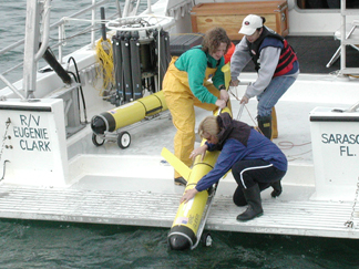
Rutgers University researchers deploy
a robotic underwater “glider” to look for red tides — large,
sometimes toxic algal blooms — in Florida. Oceanographers are using the
same technology to better understand the development of low-oxygen areas that
threaten shellfish offshore of New Jersey. Photo courtesy of Chris Higham, Mote
Marine Lab.
The oxygen depletion, called hypoxia, often occurs offshore of rivers that drain
heavily populated and industrialized areas, such as the Hudson and Raritan.
This observation led scientists to suspect a terrestrial source of the nutrient
pollution responsible for the hypoxia, as in the Gulf of Mexico.
In the Gulf each summer, the Mississippi River brings excess nutrients —
nitrogen and phosphorus from agriculture, industry and population centers —
that fuel massive blooms of phytoplankton. The ultimate death and bacterial
decay of billions of these tiny marine organisms depletes oxygen from the bottom
waters, creating a “dead zone” similar to, though more extensive and
more severe than, the zone off New Jersey.
However, the river hypothesis did not fully explain all the observations offshore
of New Jersey. For example, certain nonindustrialized estuaries, such as that
of the Mullica River, which drains the watershed of the pristine Pinelands National
Reserve, still experience recurrent hypoxia. Additionally, events up and down
the coast seemed to coincide with strong southerly winds.
Now, Scott Glenn, an oceanographer at Rutgers University’s Institute of
Marine and Coastal Sciences in New Brunswick, N.J., and colleagues say that
the source of the nutrients and the phytoplankton is the sea and not the land.
As reported in the Dec. 24 Journal of Geophysical Research — Oceans,
they monitored the Mullica River estuary between 1993 and 2001, and found that
regions of coastal upwelling coincide with historical regions of hypoxia.
The centers of coastal upwelling, they write, form where large cold-water eddies
encounter the bumps in underwater topography caused by ancient river deltas.
The disrupted flow, combined with certain wind conditions, creates subsurface
jets of cold water that shoot onto the inner shelf, carrying abundant amounts
of nutrients and phytoplankton with them that cause the ensuing bloom.
“It is much more complicated than we thought,” Glenn says. “It
means we have to consider the entire New Jersey shelf when we look at coastal
hypoxia.” He adds, however, that rivers may still be involved in some way,
as the team has identified areas were river water is regularly transported up
to 60 kilometers offshore. This water, or areas farther offshore, still may
ultimately prove to be the original source of the phytoplankton and nutrients.
The findings may help scientists to better model and monitor coastal water quality.
“It is important that we fully understand the processes that drive coastal
hypoxia,” says Bob Connell, chief of the bureau within New Jersey’s
Department of Environmental Protection that is charged with monitoring the state’s
coastal water quality. “This understanding allows us to develop more accurate
water quality models that are used to assess different sources of nutrient loads
for coastal management planning.”
The decade-long study coincided with the development of new technologies and
the improvement and expansion of coastal monitoring efforts in the Mid-Atlantic
bight. Along with traditional oceanographic techniques, the researchers used
satellite and radar technology to monitor ocean temperature, currents and color
(an indicator of phytoplankton concentration), as well as autonomous robots,
called gliders, that can remain at sea for 30 days to continuously monitor dissolved
oxygen levels near the seafloor.
“Hopefully, this technology will get us closer to identifying where the
problem is coming from and how we will fix it,” Glenn says.
Sara Pratt
Geotimes contributing writer
Back to top
 |
Geotimes Home | AGI Home | Information Services | Geoscience Education | Public Policy | Programs | Publications | Careers |