
 A large 17th-century
earthquake comparable in size to the Dec. 26 Sumatra quake was responsible for
pushing up land in Japan, according to new research based on the sediment record
of a large tsunami.
A large 17th-century
earthquake comparable in size to the Dec. 26 Sumatra quake was responsible for
pushing up land in Japan, according to new research based on the sediment record
of a large tsunami.
In the decades after the massive quakes that occurred in Chile in 1960 and Alaska
in 1964, eyewitnesses, tide gages and changes in the ecology of nearby estuaries
all showed that the events resulted in major uplift in the regions. However,
a study in the Dec. 10 Science is the first time scientists have presented
geologic evidence of “such [decadal] post-seismic deformation in the prehistoric
period,” says paleoseismologist Yuki Sawai of Japan’s National Institute
of Advanced Industrial Science and Technology and lead author of the paper.
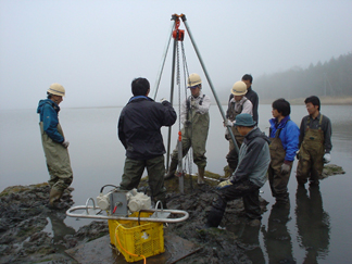
Researchers collect a core sample at a marsh in Mochirippu, on eastern Hokkaido,
Japan, during high tide. The core sample detailed the sequence of events that
followed a large earthquake, which hit offshore Japan in the mid-17th century
and may help explain the country’s present-day landscape. Photo courtesy
of Yuki Sawai.
Soil cores from two estuaries on eastern Hokkaido detailed a sequence of events
following a massive earthquake offshore in the mid-17th century. Within the
cores, fossil diatoms show a change from tidal mud flats to freshwater forest
peat above a sand layer that researchers believe was deposited by a tsunami
triggered by the unusually large temblor.
The 10-centimeter-thick layer of sand was found within tidal mud layers. The
layer’s location indicates that the tsunami occurred while the region was
still underwater and, therefore, that the uplift occurred not during the quake,
but in the decades after it.
“It is the sequence of sediments that is key,” says Elizabeth Hearn,
a seismologist at the University of British Columbia, Vancouver, who studies
earthquake-related deformation along plate boundaries. “The fact that tsunami
sands give way to shallow water sediments, and then peat [indicates that] the
land must have been emerging from below sea level to produce such a sequence.”
Explaining the origin of the uplift also solves a longstanding paradox in Japanese
geology: The island of Hokkaido is both sinking and rising. Hokkaido, Japan’s
northernmost island, sits 60 to 80 kilometers above the Kuril subduction zone,
where the Pacific plate is subducting beneath Asia at a rate of 8 to 9 centimeters
per century. However, while the Pacific plate is dragging Hokkaido down, the
geology of the region shows that the land was being uplifted during the past
125,000 years.
Large subduction zone earthquakes are known to cause warping of the crust, with
the most dramatic deformation occurring during a quake. But in the past 200
years of Hokkaido’s recorded history, very few incidents of uplift were
noted despite the occurrence of several earthquakes greater than magnitude 8,
including ones in 1952, 1973 and 2003.
Other slow deformation can also occur, however, for days, weeks, months, years
or even decades after a quake. In the past 3,000 years of geologic history,
there were several incidents of uplift that were tantalizingly close to unusually
large or “outsized” quakes, evidenced by tsunami sand layers. But
until now, strong geologic evidence of deformation following a megaquake was
lacking.
Sawai and colleagues estimate that a rupture at least twice as long as the 1973
or 2003 quake would be required to set off an earthquake large enough to cause
the observed uplift. “The mega-rupture the authors are suggesting may be
quite comparable to the recent magnitude-9 Sumatra earthquake,” says Roland
Burgmann, a seismologist at the University of California, Berkeley. “Here
also, previous historic earthquakes in the region did not suggest a prior occurrence
of such a large earthquake rupture.”
The researchers suspect that on Hokkaido, the large, shallow quake ruptured
the plate boundary offshore, allowing uplift of the Pacific coast to occur —
either by slow creep below the boundary break or by gradual elastic rebound
of the crust in response to stress relaxation in the mantle. “In a sense,”
Hearn says, “the mantle gradually loosens its grip on the base of the elastic
plate, allowing it to deform slowly over decades after the quake.”
Burgmann says that the new study will help seismologists better understand how
earthquake hazards unfold over time, “and thus significantly improve earthquake
forecasts, which provide statistical probabilities of earthquakes over several
years or decades.” It will also help, he says, hone models of stress release
at plate boundaries and better explain how a subducting plate behaves at depth.
Sawai next plans to tackle the question of how often such unusually large earthquakes,
and any subsequent uplift, recur.
Sara Pratt
Geotimes contributing writer
Back to top
 |
Geotimes Home | AGI Home | Information Services | Geoscience Education | Public Policy | Programs | Publications | Careers |