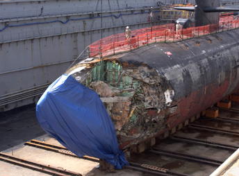
 A
U.S. Navy submarine cruising 350 miles south of Guam hit an unmapped seamount,
leaving one person dead and more than 20 people injured on Jan. 8. The USS
San Francisco had been operating under normal procedures without radar,
to avoid surveillance, while using U.S. Navy seafloor maps and satellite
imagery. Surface photography seemingly had captured the shadow of the seamount,
as it almost breaks above sea level, but had placed the underwater mountain
several hundred meters away from its actual position. The vast majority
of seamounts in the world’s oceans remain unexplored. Photo courtesy
of U.S. Navy; by Photographer’s Mate 2nd Class Mark Allen Leonesio. A
U.S. Navy submarine cruising 350 miles south of Guam hit an unmapped seamount,
leaving one person dead and more than 20 people injured on Jan. 8. The USS
San Francisco had been operating under normal procedures without radar,
to avoid surveillance, while using U.S. Navy seafloor maps and satellite
imagery. Surface photography seemingly had captured the shadow of the seamount,
as it almost breaks above sea level, but had placed the underwater mountain
several hundred meters away from its actual position. The vast majority
of seamounts in the world’s oceans remain unexplored. Photo courtesy
of U.S. Navy; by Photographer’s Mate 2nd Class Mark Allen Leonesio. |