mayheader.html

News
Notes
Glaciology
Giant
ice sheet covered the Arctic
 During
the Pleistocene, massive ice shelves scoured out portions of the Arctic
sea floor and left scars so far away from any coastline and so deep underwater
that they have given glaciologists a shock. Unlike Antarctica, the Arctic
has no landmass to support a massive continental glacier, such as the West
Antarctic Ice Sheet. But scratches in the sea floor identified from sonar
images during a submarine survey under the Arctic pack ice contradict the
common view that only smatterings of icebergs and a glaze of perennial
sea ice several meters thick have ever covered the North Pole.
During
the Pleistocene, massive ice shelves scoured out portions of the Arctic
sea floor and left scars so far away from any coastline and so deep underwater
that they have given glaciologists a shock. Unlike Antarctica, the Arctic
has no landmass to support a massive continental glacier, such as the West
Antarctic Ice Sheet. But scratches in the sea floor identified from sonar
images during a submarine survey under the Arctic pack ice contradict the
common view that only smatterings of icebergs and a glaze of perennial
sea ice several meters thick have ever covered the North Pole.
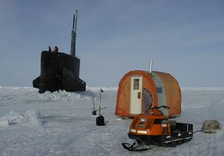
[At right: Submarine USS
Hawkbill breaks through the surface at Ice Camp Lyon off Barrow, Alaska.
Margo Edwards.]
Today in this northernmost stretch of ocean, icebergs bob along with
50-meter draughts, the sea floor far out of reach nearly 1,000 meters below.
In contrast, the research team led by Leonid Polyak of the Byrd Polar Research
Center at Ohio State University and Margo Edwards of the University of
Hawaii found the rakings of ice trails dating back to when sea level was
just 100 to 150 meters lower than it is now. That leaves 850 meters. Icebergs
didnt make these marks.
Currently, the worlds largest icebergs breaking off of the continental
ice sheets of Greenland and Antarctica draw at most 550 meters. Drifting
icebergs, with nine-tenths of their mass underwater, can leave chaotic
scratches across the seafloor. But ice sheets scrape symmetrically and
the patterns Polyak and his colleagues reported in the March 22 Nature
were sets of evenly spaced, parallel grooves. The spatial patterns indicate
that immense, Antarctic-type ice shelves 1,000 meters thick and hundreds
of kilometers long once covered the Arctic Ocean. Such an ice plow raises
a number of questions for scientists about the Arctics climatic past.
Ice sheets are glaciers more than 50,000 square kilometers in area
that smother a landmass in all directions with no regard to the underlying
topography. Confined now to Antarctica and Greenland, ice sheets carved
out a legacy during the ice ages of the Pleistocene epoch throughout North
America and northern Europe. When ice sheets hit the sea they do not come
to a dead stop. They grow out over the continental slope, forming ice shelves
with sea-side cliffs rising 50 meters or more above sea level that periodically
break off to form icebergs.
Heavy pack ice, formed from currents and wind compacting sea ice into
a tight mass, limits the operational capabilities for polar researchers
wanting to study the sea floor. Only strong icebreakers can work in the
Arctic Ocean, which is very expensive, and even they are wary of going
into the central areas with pack ice of several meters thick, Polyak says.
A nuclear submarine was just a present from the gods for us.
Polyaks team joined the last leg of the five-year Science Ice Exercises
(SCICEX) project sponsored by the U.S. Navys submarine community, the
Office of Naval Research and the National Science Foundation. While Polyak
stayed ashore analyzing data, chief scientists Edwards and Bernard Coakley
of Tulane University worked aboard the USS Hawkbill during its eight-week
expedition in 1999.
The teams report indicates that ice sheets off of Eurasia and North
America did not rapidly break apart upon encountering the sea, as previously
thought, says Robert Spielhagen of GEOMAR, a German center for marine geosciences.
From the isostatic rebound in formerly glaciated areas, ice thickness
of several kilometers have been calculated for Scandinavia and glaciated
North America. From that, a 1,000-meter thick ice tongue reaching into
the Arctic seems not impossible.
Polyak and his colleagues targeted shallow sea floor regions of the
Arctic Ocean and found markings on the 1,000-meter deep Lomonosov Ridge
near the North Pole and on the 700-meter deep Chukchi Borderland near Alaska.
The erosional features on the Lomonosov Ridge clearly indicate that the
eroding ice shelf was coming from the shelf of the Barents and Kara seas,
Polyak says. On the Chukchi Borderland all features indicate ice movement
from the eastern Alaska or, more likely, the Canadian Arctic Archipelago.
If these markings were contemporaneous, it would support the theory first
proposed in 1888 by W. Thomson and revived in 1970 by J. Mercer that
a giant ice sheet covered the Arctic Ocean during the Pleistocene. The
depths of the scours on the Lomonosov Ridge also match scars discovered
in 1994 on the Yermak Plateau that had sparked some disagreement among
scientists about their cause.
Its difficult for many climatologists to believe in large ice sheets
or ice shelves in the high Arctic, Polyak says. During glacial periods,
the Scandinavian Ice Sheet, for example, and others along the Arctics
periphery blocked most of the moisture fluxes considered critical for ice
sheets to grow. However, some argue that the temperatures were so low
that you didnt really need much moisture to initiate those ice shelves,
he says.
Still, others suggest looking between glacial intervals. During the
last glacial maximum, about 20,000 years ago, the North Atlantic was probably
too cold to feed fast-flowing ice sheets, Spielhagen wrote in a News and
Views article in the same issue of Nature. It could have been that conditions
intermediate between glacials and interglacials, or interstadials when
water temperatures and evaporation were higher than in full glacials
were more favorable to the growth of large ice sheets in the Eurasion Arctic.
Indeed, during the interstadial of around 70,000 years ago, ice sheets
reached much further to the east than at any time since then.
Putting a time stamp on the markings will help to establish whether
ice shelves attacked the Arctic Ocean from all sides at once or if several
glacial and interglacial periods were involved. In February, Polyak submitted
a proposal to the National Science Foundation to take core samples of the
Chukchi Borderland in the summer of 2002 aboard the icebreaker USCGS Healy.
So far we have only limited core material that characterizes the stratigraphy
of those glaciogenic features. His current estimate indicates the erosion
on the Lomonosov Ridge is the oldest, possibly dating back to 600,000 years
ago. The youngest features may have occurred as recently as the last glacial
maximum, 20,000 years ago.
Christina Reed
