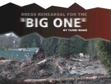

| On Feb. 28 at 10:54 am, a magnitude-6.8 earthquake cracked the dome of the state capitol in Olympia, Wash. |
Casualties were minimal and damages were low. Modern buildings and structures
performed well. Emergency response was smooth. Public awareness was heightened.
Many structures had undergone nonstructural improvements: through Seattles
participation in Project Impact, a prevention program initiated by the
Federal Emergency Management Agency (FEMA), water tanks sitting atop school
buildings were removed, preventing what might have been costly water damage
after the quake.
But the main reason damage was minimal is because this quake was not
the big one. Because the quake was centered so deep in the earth, ground
shaking was damped and so was the impact on communities. Also, the quake
occurred in a low rainfall year, which greatly minimized landslide damages.
An instant response
 Earthquake
preparation starts long before an earthquake strikes. Preparedness can
determine the severity of damages and the efficiency of emergency response.
For example, building codes have improved to accommodate ground shaking
levels expected from design level, or largest expected, earthquakes.
At the same time, the science of determining the magnitude of a design
level quake and what kind of shaking it will cause has improved in recent
decades. Thus, while old buildings may be vulnerable to significant damage
and even collapse, newer buildings are expected to withstand major quakes.
Earthquake
preparation starts long before an earthquake strikes. Preparedness can
determine the severity of damages and the efficiency of emergency response.
For example, building codes have improved to accommodate ground shaking
levels expected from design level, or largest expected, earthquakes.
At the same time, the science of determining the magnitude of a design
level quake and what kind of shaking it will cause has improved in recent
decades. Thus, while old buildings may be vulnerable to significant damage
and even collapse, newer buildings are expected to withstand major quakes.
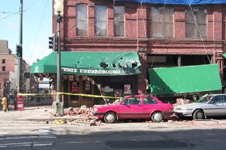
[At right: Damage to the Fenix Underground, a nightclub in Seattles Pioneer Square district. Courtesy of the Oregon Department of Geology and Mineral Industries.]
And in this information age, seismic instruments are being linked as
networks, making it possible to calculate an earthquakes magnitude and
location soon after it hits. This ability, in turn, enables emergency managers
to approximate the locations of the heaviest hit regions and the emergency
response that is needed.
After any large earthquake, one of the biggest challenges is determining
all the damage and establishing the total cost. In the past, damage cost
estimates by cities and counties would trickle in to state officials over
days, weeks, even months. The impact of the quake and extent of the damage
had to be approximated until all the reports were in, and only then could
the state request federal relief funds.
For the Nisqually earthquake, a combination of new technology, preparedness
and happenstance meant a relatively smooth and efficient aftermath. At
the states Emergency Operations Center in Camp Murray, state earthquake
emergency coordinator George Crawford developed rough estimates of the
damage costs within two hours of the shaking. The center, built in the
late 1990s, was close to the epicenter. But because it incorporated a friction
pendulum base isolation system that damped ground shaking, it continued
operating during the quake and suffered only a minor swaying motion.
Crawford modeled the earthquake impacts by inputting the earthquake
data reported by the U.S. Geological Survey (USGS) into GIS-based, HAZUS
loss-estimation software developed by FEMA. Soon after, FEMA, which input
data on the soils, building inventory and price inflaters, developed
higher cost estimates. Using computer simulations, Glen Woodbury, the state
emergency management director, reported estimated damages at over $1 billion.
Although the details of the damage and losses were computer estimates rather
than actual reports, the quick estimates expedited the overall emergency
recovery efforts.
Public awareness about earthquakes has been on the increase in the
Pacific Northwest since the mid-to-late 1980s. At that time, geologists
discovered that the Cascadia subduction zone was seismogenic. Over the
following years, the efforts of many, notably Brian Atwater of the USGS,
showed that the zone can generate a magnitude-9 earthquake. Scientists
are still collecting data and sharing that information with the public.
Public awareness and important tips on citizen response (duck, cover and
hold) continually increase.
Public awareness became even stronger when the USGS found the Seattle
fault and the FEMA Project Impact programs started in Seattle and in King
and Pierce counties. Project Impact generated important connections among
the stakeholders that went far beyond the emergency managers. Hundreds
of homes were tied to their foundations and schools underwent nonstructural
mitigation measures. This combination of years of preparation, public
awareness efforts, new technology and luck all contributed to low damage
and the smooth aftermath.
Damage: now and next time
The depth of the quake meant that the seismic waves had to travel long
distances and had a long time to lose energy before they started shaking
the surface. In future quakes, we may not be so lucky. When the Cascadia
subduction zone, which extends from northern California to British Columbia,
or the urban Seattle fault or Portland Hills fault unzips, we could experience
much worse damage.
In the days that followed the quake, I was part of a team with the
Oregon Department of Geology and Mineral Industries (DOGAMI), which coordinated
Oregons field efforts to investigate the earthquake. We aimed to assess
damage and to expand our technical understanding of seismic ground response
(attenuation and amplification), building and lifeline performance and
secondary hazards (landslides and liquefaction). We focused on gathering
field data and acting as a source of technical information for Oregons
media and public. We gathered fragile and perishable geologic and engineering
evidence, such as sand boils that liquefaction produces and rainfall erases.
We worked closely with others in the Puget Sound region to augment ongoing
assessment efforts. The March 2-4 investigation included damage surveys
in Olympia, Seattle, Tumwater, Burien, Maplewood, Tacoma and Nisqually.
The team found serious damage, although it was less than what is observed
for most large urban earthquakes. Damage was found in older buildings,
old lifelines (such as old bridges) in areas of poor soils, steep slopes
(landslide-prone areas) and in structures and areas that, for the most
part, could be predicted as vulnerable. Washington inspectors red-tagged
hundreds of buildings as unsafe. In places, ground failures liquefaction,
lateral spreading, settlement and landslides were the primary causes
of earthquake-related damage.
Damage to infrastructure is a particular concern because the community
health and economy depend on them. The team observed infrastructure damage
due to ground shaking and poor soil conditions at several locations:
Washington Gov. Gary Locke and emergency officials were personally notified
of the earthquake by the shaking itself, and set to work the moment the
shaking ended. The governor was quick to declare a state disaster within
hours of the quake. Later that day, President Bush sent his new FEMA director,
Joe Allbaugh, along with members of Washingtons congressional delegation,
including Sens. Maria Cantwell (D) and Patty Murray (D) and Reps. Bryan
Baird (D), Jay Inslee (D), Jim McDermott (D) and Jennifer Dunn (R), in
whose districts most of the damage occurred. By the following day, the
president had declared Washington state a major disaster area and started
the flow of relief money.
Even before Gov. Locke officially requested federal relief funds, Rep.
Baird whose southwest Washington district includes Olympia sent a letter
to President Bush signed by the entire Washington congressional delegation.
Baird also contacted scientists to assess threats of increased volcanic
activity at Mount St. Helens and Mount Rainier and any possible damage
at the Hanford nuclear site in central Washington.
It will take years to repay the costs of the Nisqually quake. Just
as with 1993s magnitude-5.6 quake in Scotts Mills, Ore., where the Oregon
state capitol suffered millions of dollars of damage, the Olympia capitol
will require tens of millions of dollars of repairs that will be passed
along to the taxpayers.
In direct response to the Nisqually quake, Sen. Diane Feinstein (D-Calif.)
introduced comprehensive earthquake legislation (Senate Bill 424) for lessening
earthquake damage. Feinstein states There is no question that mitigation
efforts save dollars and lives in the long run. ... Earthquakes impact
all segments of the communities they strike, individuals, businesses and
public services such as police, fire, hospitals and schools. Damage often
creates economic ripples through the community and beyond state borders.
Also in response, Rep. Earl Blumenauer (D-Ore.) asked the White House
Office of Management and Budget to provide funds in the General Service
Administrations budget for preserving historic properties. Blumenauer
knows that many buildings in Portland, such as the Pioneer Square Federal
Courthouse, are at risk to earthquake damage. He states: Ensuring
that the hundreds of federal historic properties are preserved and retrofitted
to provide safe and accessible work and public spaces is a critical component
of creating communities where our families, and federal employees, are
safe, healthy and economically secure.
In Oregon, new state policies focus on first determining the risk to
state-owned facilities, including universities, prisons, hospitals and
office buildings. In the current state legislature, Sen. Peter Courtney
(D-Salem/Keizer) is championing several earthquake bills that target critical
community functions: safety for schools, operational fire stations and
operational hospitals. His last bill deals with personal safety drills
at large businesses and government departments.
Although the Pacific Northwest is not as earthquake-prone as parts
of California, future shaking is certain. From our recent investigation,
the Oregon team found that preparation pays off. Liquefaction hazard mapping
shows where ground failure damage will be concentrated. Bolting down bookcases,
file cabinets and computers, as done in Washingtons mitigation program,
works. Nonstructural mitigation, such as bracing parapets and chimneys,
is also effective.
The nations policy-makers need to address the risks earthquakes pose,
and scientists need to help them. In the Pacific Northwest, the looming
threat is the big one that could occur along the Cascadia subduction
zone. My own estimates of the damage that could result in Oregon from a
magnitude-8.5 quake are well over $12 billion to buildings (not including
lifelines such as bridges) and more than 13,000 casualties. Other serious
threats are urban earthquakes on the Seattle or the Portland Hills faults.
Critical functions, such as emergency centers, fire stations, police
stations and hospitals, need to continue functioning right after an earthquake.
And infrastructure, such as electricity, telecommunications and roads,
needs to continue working to support critical functions. Nuts and bolts
work can be performed without investing in detailed studies and without
investing a fortune. Preparing for an earthquake can be as simple as bracing
parapets in areas of high pedestrian traffic and improving schools, which
often double as shelters, in areas of moderate-to-high seismicity.
An earthquake in the classroom
It just so happened that on Feb. 28, at 10:54 a.m., professor Bob Filson
was pointing to a drawing of a fence that illustrated offset along the
San Andreas fault. After an earthquake ... he was saying.
And then the display cases in his Green River Community College classroom
in Auburn, Wash., started rattling. One of his colleagues, physics instructor
Keith Clay, is a big cut-up, Filson says, so at first he thought the
rattling was one of Clays practical jokes. But soon he and his students
realized it was the real thing. An earthquake.
His students ducked under their desks. Filson looked worriedly out
the window. The trees outside were just moving incredibly. It looked like
a windstorm outside, he says.
Filson, who earned his geology Ph.D. at the University of Washington,
has been teaching about earthquakes for most of his 20 years at the community
college. But never has Earth provided such a hands-on teaching tool as
the magnitude-6.8 Nisqually quake that shook the states of Washington and
Oregon that day. Ive never experienced an earthquake of that magnitude,
he says.
After the 45 seconds of shaking ended, Filsons students stood up and
applauded.
His class was the last to evacuate, as his students, many of them training
to be elementary school teachers, wanted to discuss the quake and find
out its magnitude from the Internet. But communication lines were busy,
so the students instead bombarded their professor with questions. How large
was the quake? Where did it start? Why did it feel different at the beginning?
You could feel the difference between the P and S waves and the surface
waves, so we talked about that, Filson says. The surface waves brought
on slower, higher amplitude motions. Much like being in a boat.
Because nothing fell off the classs display shelves and the classroom
sustained no damage, Filson had guessed the quake was somewhere in the
magnitude-6 range, but not close to 7. He now attributes the low damage
to the quakes depth, and to the fact that the college sits 40 miles from
the epicenter, was built atop glacial till less prone to liquefaction than
soils beneath areas of higher damage, and was built in the 1960s with some
provisions for quakes.
The interdisciplinary science class covers physics, geology and chemistry,
and covers plate tectonics in the context of climate change. We just happened
to be on that subject, so it really was unusual, Filson says. Ive talked
about the San Andreas and earthquakes for many years. These things just
happen. Just by chance.
Kristina Bartlett