mayheader.html

Geophenomena
Earthquake
Devastates Vulnerable India
Christina Reed
 One
small defining moment of pride greeted Mahendra Singh when he returned
to India to evaluate the damage from the magnitude-7.7 earthquake that
struck the country on Jan. 26. About 80 miles southeast of the city of
Bhuj was a railroad bridge that the Virginia Tech engineering professor
had helped design and build back in 1964, when he was fresh out of the
University of Roorkee. And after Jan. 26, the bridge was still standing.
Many other structures were not.
One
small defining moment of pride greeted Mahendra Singh when he returned
to India to evaluate the damage from the magnitude-7.7 earthquake that
struck the country on Jan. 26. About 80 miles southeast of the city of
Bhuj was a railroad bridge that the Virginia Tech engineering professor
had helped design and build back in 1964, when he was fresh out of the
University of Roorkee. And after Jan. 26, the bridge was still standing.
Many other structures were not.
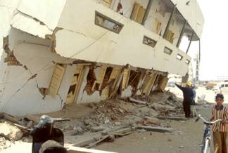
[At right: Researchers from
the U.S. Mid-America Earthquake Center investigate a damaged building in
Ghandidham, a city 100 kilometers southeast of the Jan. 26 quakes epicenter.
Image courtesy of the Mid-America Earthquake Center.]
When the earthquake hit the state of Gujarat, it turned the cities of
Bhuj, Anjar, Bhachau, Gandhidham, Kukuma, Ratnar, Lodai and Kottar along
with nearby villages to ruins in less than two minutes. In Ahmedabad, 240
kilometers from the epicenter, upper- and middle-class apartment buildings
pancaked on their lower levels.
The quake left more than 20,000 people confirmed dead, with thousands
more believed buried under the rubble.
Devastation resulted not from the size of the quake alone, but more
so from inadequate construction and poor adherence to advised, but not
mandatory, building codes, engineers say.
When the Gujarat earthquake hit, it ruptured a fault deep within the
crust that scientists are still looking to identify. It broke the crust
between 17 and 40 kilometers depth thats 17 kilometers of crust that
didnt break, or at least 10. We dont know how shallow it actually broke
up to, says William Lettis, an engineering geologist in Walnut Creek,
Calif. There is no evidence of any primary surface fault rupture or concentrated
folding or warping. The quake hit on whats known as a blind fault and
may give insight to geologists studying the New Madrid earthquakes that
struck the Midwestern United States in 1811 and 1812.
There are a great many lessons to be learned from this earthquake.
We just dont know which classroom we are in yet, Lettis says. The lessons
to be learned are dependent on whether we are in an intraplate tectonic
setting similar to New Madrid or to an active fold and thrust belt transitional
to the Himalayan plate margin about 400 kilometers to the north.
In 1819 an earthquake on a fault near the Pakistan border felled buildings
in India, killing close to 2,000 people. It was this quake that eventually
classified the state of Gujarat as a level 5 seismic zone, the highest
level for building codes in India.
Earthquake-resistant measures were developed as early as 1962 in the
form of standard design criteria and in 1967 as an earthquake-resistant
building construction code of practice, wrote Anand S. Arya in a presentation
to the 12th World Conference on Earthquake Engineering in New Zealand last
year. Since these are not mandatory by law, the construction in the informal
sector proceeds without considering the safety provisions. Lack of regulation
either for planning or settlements or in the building bylaws allows buildings
to be added every year without incorporating earthquake-resistant measures,
Arya added.
Many of the structures in the hard-hit cities were unprepared for a
quake. Many apartment complexes built in the last 20 years have no walls
on the ground floor, for example. Instead, columns support the upper stories,
providing a ground-floor garage to protect cars from the sun. But really
the garage is causing the problem, says Eduardo Miranda of Stanford Universitys
Civil and Environmental Engineering School. When the earthquake struck,
the columns buckled and snapped under the weight of the high-rise apartment
structures. This first floor disappears and the whole building comes down
after that a person with no feet cant stand, he says.
Indeed, Miranda says, much of the damage in Ahmadabad could be linked
to column-supported buildings. Only one strong motion record could be obtained
from the city, and the change in ground velocity that it measured was slightly
higher than what would have been expected for a magnitude-7.7 earthquake
in a city that is 250 kilometers from the epicenter. Calculations estimated
that such a quake should have pushed the buildings sideways with a force
equal to 6 to 7 percent of their weight, roughly what many were designed
to withstand. But the one record indicated that the lateral acceleration
was 10 percent of the acceleration of gravity (or g).
Even though the peak ground acceleration was slightly higher than expected,
10 percent g does not explain the amount of damage observed in the city.
The damage that took place correlated with poor construction practice,
Miranda says. Ten percent of the acceleration of gravity is relatively
small compared to something that would produce a lot of damage. The 1989
Loma Prieta earthquake was 60 percent g. The Northridge 1994 earthquake
record was more than 100 percent g that means for a fraction of a second,
its like putting the building sideways, feeling its whole weight of the
structure pushed laterally.
Rakesh Goel of California Polytechnic State University in San Luis Obispo
agrees. Most of the buildings in Ahmadabad are constructed to support only
4 to 6 percent of their weight pushed sideways, Goel wrote in a report
for the Earthquake Engineering Research Institute in Oakland, Calif. However,
the extent of damage observed was significantly more than expected, Goel
adds. Much of the damage can be ascribed to the typical open-framed ground
floor construction, but low quality material could also be a key factor.
In many instances, only one out of several similarly constructed buildings
in the same apartment complex collapsed.
The concrete disintegrated within
the reinforcement cage; when touched, the concrete appeared to have very
little cement content. Goel noted that preparing concrete with local groundwater,
which has a high salinity, may have affected the concrete quality.
Mud and stone are commonly used in villages where buildings are made
with material that is easily available. In Ratnar, a village between Anjar
and Bhuj, the collapse of the buildings reportedly killed 300 people. Most
of the houses are kutcha-pucca type houses, made of brick and mud mortar,
or houses made simply of mud walls. The extensive shaking during the earthquake
first cracked and then crumbled the homes. The initial P motion lasted
15 seconds while the main S waves were recorded as lasting 85 seconds followed
by several minutes of lower level shaking. In Seattle, the Feb. 28 Nisqually
earthquake lasted 45 seconds.
When Mahendra Singh visited India after the Jan. 26 earthquake, I was
very sad to see the damage in Ahmadabad and these areas; sad to see the
whole thing, he says. He traveled to the small village of Surajbari near
the bank of the Arabian Sea on the Gulf of Kutch, about 35 miles from the
epicenter, and found the old highway bridge that led across the tidal creeks
severely damaged.
Nearby, the railroad he had worked on in the 1960s, as a beginning professional
engineer for Indian Railways, came out of the earthquake with only its
tracks misaligned. And the newest highway bridge crossing the seas ingress
went practically unscathed.
When the railroad company constructed its bridge we were concerned
about earthquakes, Singh says. In 1956, an earthquake disrupted railway
services after hitting the city of Anjar, about 30 miles south of Bhuj.
Indian Railways designed the bridge near Surajbari so that in case of shaking
it could withstand 10 percent of its weight pushed sideways. The railroad
company built the bridge using 62 spans of 60-foot steel girders and imported
salt-free water to mix the concrete. Although the highway bridge was also
built in the 1960s, it was made of reinforced concrete box-girders, making
it heavier and more vulnerable to earthquakes than the railroad bridge.
After the Jan. 26 quake, the railway crew could run the trains again
after only a few hours spent realigning the girders and fixing other minor
damages. In contrast, all the bearings under the old highways box girders
were smashed and one of the piers had tilted, forcing traffic to a single
lane unsuitable for heavy vehicles.
Near Surajbari, about 200 yards east of the old highway bridge, a new
highway bridge is nearly completed. The new highway bridge did not have
much problems in this quake, Singh says. It uses three pre-stressed concrete
girders under the deck.
Cranes hoisted the 32.5-meter-long girders, which were cast on site
in a shop. Only one span in the middle remained to be completed at the
time of the quake. The new bridge construction clearly indicates a better
design for highway bridges at least, Singh says.
Earthlinks
Geological Survey of India
http://www.gsi.gov.in/
Mid-America Earthquake Center
http://mae.ce.uiuc.edu/
IRIS Consortium site on India quake
http://www.iris.washington.edu/DOCS/sindia.htm
USGS site on India quake
http://earthquake.usgs.gov/activity/latest/eq_01_01_26/
USGS National Earthquake Information Center
http://neic.usgs.gov