Geotimes

Web Feature
Florida's Springs in Jeopardy
Thomas
M. Scott
The
bank was dense with magnolia and loblolly bay, sweet gum and gray-barked ash.
He went down to the spring in the cool darkness of their shadows. A sharp
pleasure came over him. This was a secret and a lovely place.
Marjory Kinnan Rawlings, The Yearling, 1938
Slowly, we paddle our johnboat under arching, ancient live oak branches laden
with pale green bromeliads, wild orchards and ferns. Large gar and bass hang
suspended in the cool, clear water of the spring run, moving only slightly
as the boat passes. Gazing into the crystalline depths, it is difficult to
believe that the spring, its critters and plants, are changing.
 People are changing
them. Florida’s springs are in trouble. The threats to these valuable
natural resources mirror the threats to the unseen aquifers that feed them.
As researchers with the Florida Geological Survey, it is our job to sample
the waters and take an inventory of their health.
People are changing
them. Florida’s springs are in trouble. The threats to these valuable
natural resources mirror the threats to the unseen aquifers that feed them.
As researchers with the Florida Geological Survey, it is our job to sample
the waters and take an inventory of their health.
Florida’s population has exploded. Between 1950 and 1990, the population
more than quadrupled, bringing dramatic increases in water use and changes
in land use. As a result, the discharge amounts of springs and the quality
of their waters have experienced documented changes. Citizens and scientists
alike have recognized the threat to this fragile natural resource.
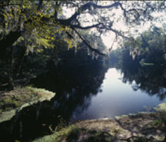
The state-owned Santa Fe River
Rise in northern Florida is the point where the underground Santa Fe River
returns to the surface. Photo courtesy of Thomas Scott, Florida Geological
Survey
Water from Florida’s largest springs is a natural discharge, primarily
from the Floridan aquifer system, the state’s main aquifer. The springs
provide a window into the aquifer, allowing us to assess its health, —
the water discharging from the spring vents comes directly from the aquifer
and has the same chemical character as the groundwater.
Over the past several decades, hydrogeologists have recognized a decline in
the water quality of many of Florida’s springs and thus a decline in
the aquifer’s water quality. Rainfall provides the recharge to the aquifer
system. Chemical and biological constituents that enter the aquifer through
recharge affect the spring water quality and flora and fauna of springs and
spring runs .
As water quality in the aquifer has declined over many years, the flora and
fauna associated with the springs and aquatic cave systems have also been
negatively affected.
In the 1998 Florida Water Atlas, Edward Fernald and Elizabeth Purdom note
that the change in water quality is a direct result of Florida’s increased
population and changed land use patterns. The ways people use the land often
introduce contaminants into the waters that recharge springs. As a result,
only a limited number of Florida’s springs remain pristine. Our studies
show that of the 49 individual vents sampled from the state’s 33 largest
springs, 40 show water chemistry changes from human influences.
Water into the springs
Florida enjoys a humid, subtropical climate throughout much of the state. Rainfall
in the area of the major springs ranges from 50 inches to 60 inches per year,
according to the Florida Water Atlas. The state’s climate and geologic
framework give Florida an abundance of fresh groundwater. Last year, using known
thicknesses of the Florida aquifer system, distribution of fresh water in the
aquifer, and average porosities, we estimated that the Florida aquifer system
contains more than 2.2 quadrillion (2.2 x 10¹⁵) gallons of fresh water. More
than 10 million people and many agricultural concerns rely on groundwater from
the aquifer system, which is one of the most productive in the world.
The Florida Platform, of which the Florida peninsula is less than half, is more
than 300 miles wide. At the maximum, it extends more than 150 miles under the
Gulf of Mexico and more than 70 miles under the Atlantic Ocean. The platform
is composed of a thick sequence of variably permeable carbonate sediments (limestone
and dolostone) lying on older igneous, metamorphic and sedimentary rocks. The
carbonate sediments can be 4,000 feet thick. A sequence of sand, silt and clay
with variable amounts of limestone and shell overlie the carbonate sequence.
In portions of the west-central and north-central peninsula and in the central
panhandle, the carbonate rocks, predominantly limestone, occur at or very near
the surface. Away from these areas, the overlying sand, silt and clay sequence
becomes thicker. The complex Floridan aquifer system occurs within this thick
sequence of permeable limestone and dolostone. Because the carbonate rocks are
permeable, they host an interconnected pore space that enables fresh water to
accumulate and flow.
Recharge to the aquifer system occurs over approximately 55 percent of the state
as rainwater filters through overlying sediments. Rainfall picks up both natural
and anthropogenic components as it seeps into the ground. Recharge rates vary
from less than one inch per year to more than 10 inches per year. Recharge water
entering the upper Floridian aquifer system can remain in the aquifer for more
than 20 years before it discharges from a spring. Karst features are common
within the recharge areas. Many sinkholes are not naturally plugged and allow
surface water to directly recharge the aquifer without filtering through and
reacting with the overlying sediments.
Florida hosts two types of springs: seeps, or water table springs, and karst
springs, or artesian springs. The majority of Florida’s more than 700 springs
and all of its largest springs are karst springs, which form when groundwater
discharges to the surface through a karst opening.
Seeps springs form when rainwater percolating down through permeable sediments
eventually encounters an impermeable or much less permeable formation, forcing
the water to move laterally. Eventually the water may reach the surface in a
lower lying area and form a seep, such as the steephead seeps that stretch along
the eastern side of the Apalachicola River.
The problems in Florida’s springs have taken many years to develop and
to be recognized. As Florida’s population increased, land-use patterns
changed dramatically. Cities with landfills and other associated infrastructure
were built in areas where natural recharge supplies water to the aquifer. The
resulting changes in the recharge water quality slowly altered the aquifer system’s
water quality. The alterations in the aquifer’s water affected the flora
and fauna of the springs and spring runs, changes that were manifested slowly.
Eventually, the changes were dramatic enough that scientists and private citizens
became aware of them. Research efforts have begun to document, understand and
reverse the degradation of our springs.
Taking inventory
Springs are often a focal point of life in Florida’s warm climate. Anecdotal
information from long-time Florida residents suggests that flow in many springs
has lessened over time. These stories also document an increase in algae in
the spring boils and runs. The people reporting these stories have, without
realizing it, informally been investigating their favorite springs. Geologists,
alerted to the changing conditions in the springs, then investigate the springs
by gathering the anecdotal stories, obtaining data from previous investigations,
collecting water samples for new analyses and comparing the new data with the
old.
 In 1947,
the Florida Geological Survey published the first Springs of Florida bulletin,
which documented 106 major and important springs in the state. The Survey revised
the bulletin in 1977, adding many springs previously undocumented and new water-quality
analyses of the spring water. By then, we knew of nearly 300 springs.
In 1947,
the Florida Geological Survey published the first Springs of Florida bulletin,
which documented 106 major and important springs in the state. The Survey revised
the bulletin in 1977, adding many springs previously undocumented and new water-quality
analyses of the spring water. By then, we knew of nearly 300 springs.
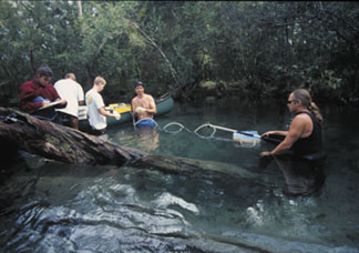
The Florida Geological Survey’s Springs
Sampling Team last September samples the spring boil at one of the vents of
the Gainer Springs complex, which in some parts vents into the Econfina Creek
in Bay County. The author, Thomas Scott, is on the far right and holds the sampling
tube with a canoe paddle so that it stays in the spring boil. The yellow box
in the canoe is a peristaltic pump that draws the water. Also pictured are,
from left, Rebecca Meegan, Harley Means, Jim Cichon and Alan Baker.
Photo by Ryan Means
A spring is most often classified based on its average discharge of water. First-magnitude
springs discharge more than 64 million gallons of water per day, or more than
100 cubic feet per second. Second-magnitude springs discharge between 6.46 and
64 million gallons of water per day and between 10 and 100 cubic feet per second.
Third- and lower-magnitude springs flow at less than 6.46 million gallons of
water per day and 10 cubic feet per second.
The Florida Geological Survey’s 2002 report on first-magnitude springs
is the initial step in revising the Springs of Florida bulletin and helping
to focus the state’s attention on the health of its springs. In 2001, at
least 700 springs had been recognized in the state and more are reported every
year. To date, we have recognized 33 first-magnitude springs, more than in any
other state or country.
Currently, the geological survey is investigating the more than 200 second-magnitude
springs in the state. Our goal is to describe as many of the more than 700 springs
as possible to establish a new baseline for monitoring the health of Florida’s
springs.
The nitrate
problem
Since the 1970s, those observing the springs have noticed changes in the springs
and spring runs. In particular, an abundance of algae appeared covering rocks,
sediments and aquatic vegetation. Biologists believe the increases in the abundance
of algae and other changes in the spring systems are being driven by increased
nitrate levels in the discharged waters. Nitrate, which is derived primarily
from fertilizers, septic tanks and animal wastes, enters the Floridan aquifer
system by direct recharge through karst features and by filtration recharge
through sediments overlying the aquifer system.
Although the Florida Department of Environmental Protection has set the drinking
water standard for nitrate at 10 milligrams per liter, nitrate levels of less
than 1 milligram per liter can cause changes in the springs’ ecosystems.
Currently, nitrate levels in the first-magnitude springs range from less than
0.004 milligrams per liter (below detection limits) to 4.1 milligrams per liter.
Typically, spring waters not affected by human activities have nitrate concentrations
of less than 0.05 milligrams per liter.
Studies of the nitrate levels from 13 first-magnitude springs in the state reveal
a nearly 20-fold increase since 1972. The 2000 report from the Florida Springs
Task Force found a direct correlation between population increase and nitrate
increase for the Weeki Wachee Springs area, as documented by the Southwest Florida
Water Management District. By comparison, concentrations of calcium and other
naturally occurring components of the water showed no significant change, indicating
little variation in the background natural environment.
The remaining pristine springs in Florida have not suffered degradation because
their recharge basins lie in areas such as the Ocala National Forest, which
has little development and agriculture. Recharge occurring in these areas does
not pick up the increased levels of nitrate and other chemicals resulting from
human land use.
Diminished spring discharges have been noted throughout the state. Natural variations
in recharge affect the springs. During the drought of 1998 to 2001, many springs
exhibited decreased flows. Some springs, even first-magnitude springs such as
Hornsby Spring, ceased flowing altogether.
Human activities also contribute to a decline in a spring’s discharge.
According to the Florida Springs Task Force report, increasing demand for groundwater
has lowered the water levels in the aquifer in some areas, reducing spring flow.
Research is being conducted to determine how much water people can draw from
the aquifer system without robbing a spring of the minimum flow it needs to
support its aquatic ecosystems.
Strategies for saving the springs
 Under direction
from David Struhs, Secretary of the Florida Department of Environmental Protection,
the state has formed a multi-agency Florida Springs Task Force to recommend
strategies for protecting and restoring Florida’s springs. The Task Force,
led by James Stevenson of the Department of Environmental Protection, taps the
expertise of 16 Floridians who represent one federal and three state agencies,
four water management districts, a state university, a regional planning council,
the business community and citizens. The task force met monthly from September
1999 to September 2000, and the 2001 Florida Legislature passed the first year
of the Florida Springs Initiative authorizing funds for the Department of Environmental
Protection to investigate the status of Florida springs and develop strategies
for their protection. Through the efforts of the Florida Springs Task Force
and through the state’s water management districts, strategies for saving
Florida’s springs are at hand.
Under direction
from David Struhs, Secretary of the Florida Department of Environmental Protection,
the state has formed a multi-agency Florida Springs Task Force to recommend
strategies for protecting and restoring Florida’s springs. The Task Force,
led by James Stevenson of the Department of Environmental Protection, taps the
expertise of 16 Floridians who represent one federal and three state agencies,
four water management districts, a state university, a regional planning council,
the business community and citizens. The task force met monthly from September
1999 to September 2000, and the 2001 Florida Legislature passed the first year
of the Florida Springs Initiative authorizing funds for the Department of Environmental
Protection to investigate the status of Florida springs and develop strategies
for their protection. Through the efforts of the Florida Springs Task Force
and through the state’s water management districts, strategies for saving
Florida’s springs are at hand.
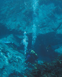
Three members of the Florida Geological
Survey’s Springs Sampling Team dive up to 20 feet in Alexander Spring last
October to investigate the Miocene Hawthorn Group around the spring’s vent.
Alexander Spring is in the Ocala National Forest. Photo courtesy of Thomas Scott.
The Florida Springs Task Force is planning a conference, “Natural Gems
— Troubled Waters,” for February 2003. The Florida Geological Survey
Hydrogeology Program is sponsoring a workshop, “Blueprints for the Management
and Protection of Springs in Florida,” this spring. The 2001 Florida Legislature
provided $2.5 million for the first year of the Springs Initiative to fund initial
research, monitoring, management and educational efforts. The 2002 Legislature
has continued the funding at this level.
The Task Force has recommended four strategies for stopping the changes human
activities are triggering in the state’s springs. The first is outreach:
educating the public and government officials, and creating working groups to
study and discuss spring basins. The second is to gather information: researching
and monitoring the water quality, discharge rates and biological communities
of springs. Third is management: making land-use decisions tailored to karst
areas, acquiring land to protect it, providing better onsite sewage treatment,
and developing Best Management Practices for landscape fertilization, agriculture,
stormwater management, sinkhole cleanup, and golf course management. The fourth
strategy of the Task Force is regulation: establishing minimum flows and levels,
planning for water supplies, and conserving water to protect spring flow and
rare, endangered species.
The efforts to save and restore Florida’s springs are just beginning. It
will take many years for the effects of the initiative to be fully recognized
and a valuable natural resource restored and preserved for future generations.
Scott is assistant state geologists
and a researcher with the Florida Geological Survey within the Florida Department
of Environmental Protection in Tallahassee. E-mail
