Geotimes

Feature
Martian Field Trips
on Earth
Geotimes staff
For nearly 40 years, several U.S. satellites and rovers and cameras and spectrometers
have orbited or even landed on Mars: the Mariner missions, Viking missions,
Mars Pathfinder, Mars Global Surveyor and 2001 Mars Odyssey. This month and
next month, NASA is scheduled to launch the Mars Exploration Rovers, robotic
field geologists that will land at two points on the planet. Following them
will be Mars Express, scheduled for a June launch, and, planned for 2005, the
Mars Reconnaissance Orbiter, Smart Lander and Long-range Rover and Scout Missions
— and those are just the planned missions that already have names.
At the same time, many researchers look to Earth for examples of or contrasts
to what we’re seeing of the Red Planet. The following stories are snapshots
of Earth analogs: places on Earth that look similar to images we’ve seen
from Mars. The researchers featured here are following these similarities and
studying these spots on Earth in detail to see whether they offer clues or contrasts
to the martian processes, past and present.
We offer these research snapshots with some caution. Earth can be an excellent
guide to other planets, but not a lone perspective. “There are so many
different things to be considered,” says Benton Clark, who has been studying
the Red Planet since the first Viking images came back in 1976. “I’m
always worried about people making their theories too comprehensive in the face
of not enough data.”
The data will continue to pour in, and researchers hope to strengthen our understanding
of the Red Planet as information travels from Mars to Earth.
The Grand Canyon: Carving a past
for martian climate
Egypt: Rivers of sand
Great sand dunes: Windswept waves
Australia: Acid waters
Atacama desert: An arid testing ground
The
Grand Canyon: Carving a past for martian climate
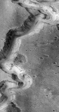 Nanedi Vallis sinuously
stretches through the cratered plains of Mars’ Xanthe Terra region. About
a kilometer deep and 2.5 kilometers wide, the origin of the canyon is unknown.
Some researchers are looking to Arizona’s Grand Canyon here on Earth to understand
Nanedi Vallis’ mysterious formation and, in turn, Mars’ ancient climate.
Nanedi Vallis sinuously
stretches through the cratered plains of Mars’ Xanthe Terra region. About
a kilometer deep and 2.5 kilometers wide, the origin of the canyon is unknown.
Some researchers are looking to Arizona’s Grand Canyon here on Earth to understand
Nanedi Vallis’ mysterious formation and, in turn, Mars’ ancient climate.
“I think that if you were standing at the surface of Nanedi Vallis, it would
look much like the Grand Canyon — steep walls, fairly deep and quite broad,”
says Jim Kasting, professor of geosciences and meteorology at Penn State. On Earth,
it took millions of years for the Colorado River to carve out the 1.5-kilometer-deep
Grand Canyon. Nanedi’s small channel, Kasting says, suggests it too formed
from a small river cutting it out over millions of years. That slow formation
would have required an atmosphere warm enough for running water, he says.
Visualizing a warm early Mars, however, is no easy task. “Cold early Mars
is the leading theory right now, because no one has a good explanation for how
early Mars could have been warm; what you see on the surface does not look like
an earthlike climate,” Kasting says. Martian river channels do not have smaller
branching channels, which on Earth represent a sustained water cycle. And researchers
have yet to see evidence on Mars’ surface of carbonates, which on Earth signal
past large amounts of the greenhouse gas carbon dioxide.
Kasting still contends that to create Nanedi Vallis over millions of years would
have required a warm early Mars. He thinks that a greenhouse effect, like on Earth,
could have been responsible. “In some ways the planets should have been more
alike back then than they are now, because Mars when it was young was still geologically
active.”
Named for the word for ‘planet’
in Sesotho, the national language of Lesotho, Africa, Nanedi Vallis is 2.5 kilometers
wide and about a kilometer deep. Researchers are looking to Arizona’s Grand
Canyon to understand the climatic environment that shaped Nanedi Vallis. NASA/JPL/Malin
Space Science Systems.
His research team has modeled an ancient martian atmosphere that includes a combination
of carbon dioxide and methane. The climate model yielded about 30 degrees of greenhouse
warming, bringing the surface temperatures up near the freezing point of water,
not quite warm enough for sustained liquid water.
Although the presence of methane on early Mars is speculative, research now in
press by Chris McKay of the NASA Ames Research Center and Monika Kress of the
University of Washington suggests that impacts could have provided a non-biological
source of the gas.
The model did not include the effect of carbon dioxide clouds, which would have
additionally warmed the atmosphere, says Kasting, who presented his team’s
findings at the American Geophysical Union meeting in December. And if the sun
were brighter, which is possible but contradicts the current leading theory, the
climate also would have been warmer, he adds.
Writing in a Dec. 6, 2002, Science article, Teresa Segura of NASA Ames
and colleagues proposed that an early Mars environment with millions of years
of sustained warm temperatures and rain are not necessary for forming rivers.
They suggest that an individual large impact, about 100 to 250 kilometers wide,
would have vaporized both the object and the martian soil, melting and precipitating
tens of meters of water. “You can get significant erosion from just a handful
of these large impact events. The brief periods of torrential rains and flash
flooding, coupled to warm temperatures, may be enough to carve rivers,” Segura
says. For something as large as Nanedi Vallis, Segura says, multiple impact events
would have been necessary to create the whole feature. Globally,
Mars would be above the freezing point of water with flowing water for years to
millennia following each impact. The rest of the time, “we think Mars was
pretty much as it is today, with a slightly higher surface pressure, but probably
similar temperatures, especially when considering a fainter sun,” Segura
says.
If, as Kasting contends, Nanedi Vallis formed slowly like the Grand Canyon, then
it would take 10,000 large impacts to create the right environment for its formation
under Segura’s impact scenario. Kasting adds that while the giant impacts
could have contributed to the martian paleoclimate, they likely would have scarred
the landscape, making it difficult for Nanedi to look as it does today.
The 25-year-long debate between cold and warm early Mars is not likely to end
soon, Kasting says. “The challenge for any theory is to explain what we see
in geomorphological evidence.” Ultimately, Kasting would like to gain insight
on how wide the habitable zone is around the sun and, by implication, other stars.
“Early Mars is a test of this idea, because it looks to many of us like early
Mars was habitable; it did have flowing liquid water at its surface, which is
the first requirement for life. Life could have evolved there, but we don’t
have a good climate theory for why.”
Lisa M. Pinsker
Back to top
Egypt:
Rivers of sand
 At his office in
the in the Smithsonian Institution’s National Air and Space Museum, Ted
Maxwell pulls out a map of Egypt and begins pointing out areas in the southwestern
desert.
At his office in
the in the Smithsonian Institution’s National Air and Space Museum, Ted
Maxwell pulls out a map of Egypt and begins pointing out areas in the southwestern
desert.
“It rained here for an hour or two in 1927. Over here there was a shower
in 1968. And it rained here in 1998. I was there, I saw it rain,” he says.
The meteorological records for this region identify the land as hyperarid. Yet
river channels zigzag below the flat, sandy surface. The only visible signs
of these Cenozoic river beds are the scattered rocks and pebbles where the bedrock
of the channel banks pokes through the red and yellow mottled plain. Only a
few fracture zones allow the presence of oases where the near-surface aquifer
can support scattered acacia mounds.
Andrew Johnston surveys the floor of the Kiseiba depression in southwest Egypt,
100 kilometers west of the Nile. Photo by Ted Maxwell.
Shortly after the Viking Landers in 1976 brought back images of rocky outcrops
on an otherwise flat, dusty surface of Mars, Maxwell, working with Farouk El-Baz,
at the time also with the Smithsonian, began to investigate the relationship
between the Red Planet and Egypt. In 1978, traveling with a team of American
and Egyptian specialists, El-Baz and Maxwell explored Gilf Kebir and Uweinat
in Egypt to verify interpretations of Earth-orbital photographs and investigate
the similarities between Earth and Mars. On Mars, several areas of dark and
light wind streaks were identical to those seen in southern Egypt, leading El-Baz
and Maxwell to interpret the light streaks as depositional, and the dark zones
as erosional surfaces.
It wasn’t until 1981 when radar images taken during the second flight of
the Space Shuttle Columbia gave the first indication that paleochannels exist
in the Egyptian desert. Jack McCauley and Carol Breed, then at the U.S. Geological
Survey, identified the now-defunct drainage pathways branching beneath the southeastern
part of the Gilf Kebir Plateau region. Their find dramatically changed Maxwell’s
opinion on the use of Egypt as an analog for the dusty deserts on Mars. Rather
than comparing features on the planets and looking for similar explanations,
today Maxwell finds analogs useful for examining how different paleoclimates
may have created similar geologic surfaces.
 Recent missions
have shown that streaks on Mars have a complex relationship with the planet’s
past and current environment. In 2002, Kenneth Edgett of Malin Space Science
Systems, Inc. reported large, dark wind streaks in the Mars Orbiter Camera views
of western Arabia Terra. “The relations between dunes, wind streak, and
subjacent terrain imply that dark-toned grains finer than those that comprise
the dunes are lifted into suspension and carried out of the craters to be deposited
on the adjacent terrain,” he wrote in the Journal of Geophysical Research.
Recent missions
have shown that streaks on Mars have a complex relationship with the planet’s
past and current environment. In 2002, Kenneth Edgett of Malin Space Science
Systems, Inc. reported large, dark wind streaks in the Mars Orbiter Camera views
of western Arabia Terra. “The relations between dunes, wind streak, and
subjacent terrain imply that dark-toned grains finer than those that comprise
the dunes are lifted into suspension and carried out of the craters to be deposited
on the adjacent terrain,” he wrote in the Journal of Geophysical Research.
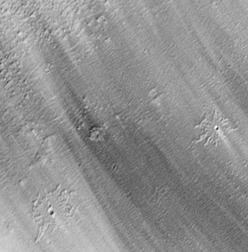
Bright and dark windstreaks in this image indicate past movement of fine sediment
across the landscape from upper left toward lower right. Two impact craters
are seen in the lower portion of the image. This picture — showing part
of the Medusae Fossae region near the martian equator — was taken in early
April 1999 and covers an area only 1 kilometer (0.62 miles) wide. NASA/JPL/MSSS.
Egypt’s streaky deserts bring into question the formation of features on
both planets. Yes, the process of wind erosion plays a significant role in the
desert morphology. But many features were not the result of the current hyperarid
climate. Instead, ancient rivers, remnants of a wetter climate, were the hidden
cause. Only wind had filled in the river channels with sand — leaving the
coarser material of rocks and pebbles along the banks of the river that now
mark the desert scene.
Maxwell and other scientists continue to urge for radar instrumentation on both
Mars orbital and landed missions. The 2003 Mars Express and 2005 Mars Reconnaissance
Orbiter missions will carry sounding radars to probe the martian crust in the
100-meter to 5-kilometer depth range, says John Grant of the Center for Earth
and Planetary Studies at the Smithsonian Institution’s National Air and
Space Museum. “In light of the extensive surficial deposits that blanket
much of Mars, radar may hold the key to unraveling some of the planet’s
outstanding mysteries,” he says, indicating for example the evolution of
the hydrologic cycle.
Interpreting whether a wetter climate helped form the desert features of Mars
is difficult. “I used to say, ‘this looks like this so they formed
the same way,’ but now I know you can’t say that for certain,”
Maxwell says. “It is better to ask what happens under severe climate conditions
and think of how different climates in the past affect what is seen now.”
On Mars the lack of small tributaries remains a puzzle to wet-weather climate
modelers. Perhaps a similar cover-up is occurring on Mars, Maxwell suggests.
But before he takes that thought any further, he’s waiting to see what
answers might lay buried beneath the surface.
Christina Reed
Back to top
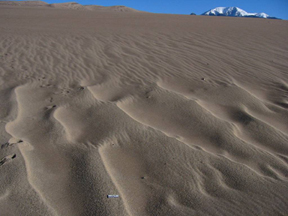
Great
sand dunes: Windswept waves
 The surface of
much of Mars looks like an ocean frozen in time. Waves stretch out to the horizon.
The distances between crests range from 10 to 60 meters. But these are not waves
made of water. Rather, they are made of solid, roughly sand-sized particles. Winds
give them shape.
The surface of
much of Mars looks like an ocean frozen in time. Waves stretch out to the horizon.
The distances between crests range from 10 to 60 meters. But these are not waves
made of water. Rather, they are made of solid, roughly sand-sized particles. Winds
give them shape.
While this terrain may sound reminiscent of the many sand dunes that dot coastal
regions on Earth, there are, in fact, very few places here that sport waves of
similar dimensions. Terrestrial dunes tend to be much larger. And the sand ripples
that undulate across many deserts tend to be much smaller.
Dark and light bands delineate waves made
of roughly sand-sized particles in this Mars Orbiter Camera image (near 20.14
degrees north, 20.78 degrees west). NASA/JPL/MSSS.
However, at Great Sand Dunes National Monument in Colorado and Edwards Air Force
Base in California, ripples grow up to 10 meters, from crest to crest, matching
the smallest waves found on Mars. Geomorphologists from the Center for Earth and
Planetary Studies (CEPS) at the Smithsonian Institution’s National Air and
Space Museum have traveled to these sites to study how the unique waves form and,
by analogy, to understand the processes behind the martian waves.
 Many ripples
on Earth consist of only sand-sized particles. However, a thin veneer of coarse
pebbles consistently coats the anomalously large ripples in the California and
Colorado field sites, says James Zimbelman, a CEPS geologist. Indeed, the wavelengths
of the ripples at those sites appears to increase in proportion to the size of
the particles sitting on the surface, as Zimbelman and colleagues showed in an
abstract for the 2002 Lunar and Planetary Science Conference (LPSC) in Houston.
Many ripples
on Earth consist of only sand-sized particles. However, a thin veneer of coarse
pebbles consistently coats the anomalously large ripples in the California and
Colorado field sites, says James Zimbelman, a CEPS geologist. Indeed, the wavelengths
of the ripples at those sites appears to increase in proportion to the size of
the particles sitting on the surface, as Zimbelman and colleagues showed in an
abstract for the 2002 Lunar and Planetary Science Conference (LPSC) in Houston.
The exact role of the pebbles is not yet known. However, larger grains can form
a protective cap, says Mary Bourke, a geomorphologist at the University of Oxford.
Wind cannot easily penetrate this cap, protecting sand grains beneath from being
blown away.
Unusually large, wind-shaped ripples in the Great Sand Dunes National Monument
in Colorado may hold clues to the processes that formed the martian features.
James Zimbelman/Sharon Wilson.
The need for a pebble veneer limits the distribution of large ripples on Earth,
Zimbelman says. Sand particles often hop downwind, bouncing off the desert surface,
and can travel long distances. In contrast, pebbles travel much more slowly; they
roll along the surface, too heavy to bounce. Pebbles rarely stray far from their
source — a stream bed or a mountainside, for example. Large ripples, therefore,
must sit near sediment sources; Great Sand Dunes National Monument lies at the
base of the Sangre de Cristo Mountains.
In addition, Zimbelman says, fluvial transport tends to separate out small grains
from larger ones, limiting their co-occurrence — the essential ingredient
for large ripples.
On Mars, however, rivers do not dominate the landscape (although they may have
been active a long time ago), limiting fluvial segregation. Also, geomorphological
sources for pebbles abound, Zimbelman says. “In the Mars Orbiter Camera images,
the large ripple-like bedforms are always around something; there tend to be hills
or knobs in close proximity. Coarse particles are likely readily available.”
But the majority of the waves on Mars are much larger than even the largest ripples
that the CEPS research crew has found on Earth. Zimbelman suggests the difference
may lie in the atmosphere and in gravity.
In addition to being limited by the availability of pebbles, ripples tend to scale
with the distance that individual sand grains hop in the wind, Zimbelman says
— the larger the hop, the longer the wavelength of the ripple. Lower gravity
on Mars means that similarly powerful winds will blow a grain further on Mars
than Earth. However, Mars’ atmosphere is also less dense than Earth’s.
That density difference means that winds must blow much more strongly on Mars
to induce an individual grain to hop up off the surface. But once the grain is
in the air, the strong winds blow it farther.
Graduate student Sharon Wilson and geomorphologist Steve Williams, both working
at the National Air and Space Museum, plan to test the reliability of the terrestrial
analog for the martian waves. They have analyzed ripples from both Great Sand
Dunes National Monument and Edwards Air Force Base and found that the height to
wavelength ratio is roughly 1:15, as reported in an abstract in March for the
2003 LPSC meeting. If the martian waves formed by mechanisms similar to the terrestrial
ones, they should have a similar ratio, Wilson says. She has already measured
the wavelengths of hundreds of ripple-like features from Mars Orbiter Camera images.
The next step is to determine the height of those waves, based on the shadows
that they cast.
Greg Peterson
Back to top
Australia:
Acid waters
In 1979, Mars researcher Benton Clark suggested that, assuming the past Mars was
very cold, pure water would not have been stable in liquid form on the planet.
He also suggested that acidic water would.
Several scientists have followed Clark in saying that water on Mars might have
been acidic. “It’s sort of popped up from time to time,” says Martha
Schaefer, a planetary geologist at the Center for Space Research in Houston.
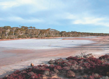 Benison’s
work started in the United States with her research on fluid inclusions —
microscopic pools of preserved liquid water — contained in halite that was
in turn layered and trapped within red sandstones and shales in North Dakota and
Kansas. Within these fluid inclusions were significant amounts of bisulfate, a
marker of sulfuric acid. The lake water and groundwater that precipitated the
halite and gypsum 270 million years ago had been acidic, with pH levels as low
as below zero, she says. In researching the Permian waters, she needed a modern
comparison. That search brought her to the modern acidic lakes in western Australia.
Benison’s
work started in the United States with her research on fluid inclusions —
microscopic pools of preserved liquid water — contained in halite that was
in turn layered and trapped within red sandstones and shales in North Dakota and
Kansas. Within these fluid inclusions were significant amounts of bisulfate, a
marker of sulfuric acid. The lake water and groundwater that precipitated the
halite and gypsum 270 million years ago had been acidic, with pH levels as low
as below zero, she says. In researching the Permian waters, she needed a modern
comparison. That search brought her to the modern acidic lakes in western Australia.
She was surprised to find both the Permian and the modern acidic waters, because
most saline waters on Earth are alkaline, she says.
Aerodrome Lake is an acid salt lake in western
Australia. Kathy Benison, Central Michigan University.
“I don’t really know what the cause of the acidity is,” Benison
adds. Volcanic activity or the presence of large ore deposits are the usual culprits
for acidic waters, she says, but aren’t factors in the area of her Permian
rocks. “I think it might have something to do with long-term weathering and
climate trends.” Weathering, she suggests, might over time eliminate the
usual buffers, such as calcite and feldspar.
In 1997, when Mars Pathfinder returned images of the martian surface, Benison
remembers thinking, “Hey, those look like my Permian rocks.” Recently,
when LaClair said she wanted to study Mars, they both saw an opportunity.
LaClair made a solution that was 39 percent sulfuric acid and 61 percent water
— the combination Clark suggested could be stable as liquid on a cold Mars.
She conducted a small-scale geomorphology experiment, first pouring dilute water
over sand, then pouring the acid solution over sand, and finally comparing the
features each created. She found some features unique to the acid solution that
also appear on Mars, Benison says.
She adds that, while their work is new, it suggests that discussions of water
on Mars should not assume that dilute water alone carved the features we see today.
“We don’t think we have enough information to say specifics on Mars;
but we think [this idea of acid water] should be considered,” she says. “When
you look at surface water and groundwater on Earth, there are all different kinds
of chemistries.”
 The idea intrigued
M. Darby Dyar of Mount Holyoke, who heard Benison’s talk on the subject during
the fall 2002 meeting of the Geological Society of America. Dyar and Schaefer
are analyzing samples from the modern Australian lakes and Permian lake deposits.
They will compare the terrestrial properties with any new mineralogical clues
waiting in the data the Mars Exploration Rovers send back. For example, the presence
of the mineral jarosite, found in some of the Australian samples, would be a good
clue, Schaefer and Benison say.
The idea intrigued
M. Darby Dyar of Mount Holyoke, who heard Benison’s talk on the subject during
the fall 2002 meeting of the Geological Society of America. Dyar and Schaefer
are analyzing samples from the modern Australian lakes and Permian lake deposits.
They will compare the terrestrial properties with any new mineralogical clues
waiting in the data the Mars Exploration Rovers send back. For example, the presence
of the mineral jarosite, found in some of the Australian samples, would be a good
clue, Schaefer and Benison say.
“This time we actually have a specific Earth analog [for acid lakes],”
Schaefer says. “It gives us a chance to study one place that’s still
active so that we can see what kind of weathering is going on.”
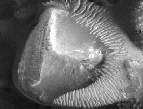
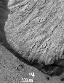
The toe of this landslide at Mars’ Ganges Chasma
sports more impact crater features than the valley below, says Deidre LaClair,
a student at Central Michigan University. This contrast is counterintuitive, she
says, because the landslide is probably the younger feature. “You’d
expect older features to have more impact craters.” The craters, LaClair
suggests, could also be places where bubbles of trapped air or gases popped and
left an imprint. She observed crater-like features form this way during an experiment
in which she ran acidic water over sand to see what types of features resulted.
NASA/JPL; Thermal Emission Imaging System aboard 2001 Mars Odyssey.
Clark adds that the mineralogy samples expected from the Mars Exploration Rovers
could yield other clues — such as sulfur-coated rocks (sulfuric acid or sulfurous
acid would react with the rocks and leave sulfur behind) or a deficiency of magnesium
or calcium. Also, the Marvel mission — set to begin scanning the martian
atmosphere in 2007 — might find atmospheric evidence for volcanic activity.
Such evidence would be quite a find, Clark says, and would also pinpoint a possible
source of any acid. “The idea is that this acidity comes from volcanoes,
because that’s what we see on Earth.”
Kristina Bartlett
Back to top
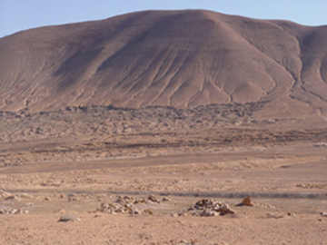
Atacama
desert: An arid testing ground
It’s another kind of picturesque: mile after mile of dry soil and aridity
in any given direction. Hardly a hint of water exists in sight. The Atacama Desert,
on the northern Chilean pacific coast, has experienced total rainfall of only
a few millimeters per decade for the last 10 to 15 million years. To astrobiologists
and planetary geochemists, this makes Atacama not only one of the oldest and driest
deserts on Earth, but also one of the best analogs on Earth for the present- day
dry conditions on Mars.
 Of course, Mars has
been dry for much longer than Atacama, perhaps billions of years longer. Mars
may have started out with a higher percentage of volatiles than Earth; however,
impacts and solar winds probably stripped away most of Mars’ early atmosphere.
Today Mars’ atmosphere, mostly carbon dioxide, is thin — approaching
100 percent humidity, but containing very little water. If you were to precipitate
the water in a column stretching from the surface of Mars to the top of its atmosphere,
you would have little more than 10 microns of water. That’s less water than
you’re likely to have on the palm of your hand at any given time.
Of course, Mars has
been dry for much longer than Atacama, perhaps billions of years longer. Mars
may have started out with a higher percentage of volatiles than Earth; however,
impacts and solar winds probably stripped away most of Mars’ early atmosphere.
Today Mars’ atmosphere, mostly carbon dioxide, is thin — approaching
100 percent humidity, but containing very little water. If you were to precipitate
the water in a column stretching from the surface of Mars to the top of its atmosphere,
you would have little more than 10 microns of water. That’s less water than
you’re likely to have on the palm of your hand at any given time.
The Yungay region of the Atacama desert in Chile provides an ideal analog for
Mars. Photo by Richard Quinn.
Whether or not life can exist in such a dry place, has been one of the driving
questions of NASA Mars exploration. In July and September of 1976, NASA’s
two Viking Landers set down on the surface of Mars. The landers each held a Biological
Package — at the time the most complex instrument ever assembled for spaceflight
— designed to conduct three experiments. Outside of the biological package,
the Vikings also contained molecular analysis instruments able to detect the organic
molecules associated with life. All of these experiments yielded results, some
even seemed positive at first, but none were conclusive. The most surprising results
came from molecular analysis, which found no organics. The question of life on
Mars remained open, but the search taught us much about the chemistry of the Martian
surface.
For NASA Astrobiologist Kim Warren-Rhodes, Atacama holds the promise of showing
what the “limits” of life really are. According to Warren-Rhodes, “In
deserts, the controlling environmental factor for life is the availability of
water. We collect meteorological and soil moisture data in order to understand
the effect of the physical environment, especially liquid water, on the microorganisms
so as to be able to quantitatively determine the limits of life as set by the
availability of water. Understanding the limits of life on Earth in desert environments
can help establish models for survival in the dry conditions on Mars.”
Life has its limits in harsh conditions, and so does life-seeking technology.
In April, researchers from NASA and Carnegie Mellon University began using Atacama
to help them develop a robot that will be better prepared to search for life in
other worlds — even those that seem inhospitable. The robot they took with
them was called Hyperion. Hyperion proved itself in 2001 in the Canadian Arctic,
where it was able to track the sun as it explored its surroundings for a 24-hour
period. The group is planning an annual visit to Atacama over the next three years.
According to project leader David Wettergreen, a research scientist at Carnegie
Mellon’s Robotics Institute, “Each time, an increasingly capable robot
will use sensing and intelligence to find land forms or environmental conditions
that could harbor life.” In 2005, the last year of the project, the group
hopes to have assembled an autonomous robot with a full array of instruments.
Nathalie Cabrol, a planetary scientist at NASA Ames and the SETI institute, calls
the three year Atacama project a “stepping stone to Mars.”
Hyperion isn’t the first instrument to be tested at Atacama. Researchers
from NASA Ames, JPL and SETI, recently used Atacama to test the Mars Oxidant Instrument
(MOI). The MOI is designed to establish the presence of reactive chemical species
in the Martian soil, dust and atmosphere. The MOI will test many of the hypotheses
that have been set forth to explain Viking’s indication that Martian surface
material was reactive. While testing MOI at Atacama, the researchers took the
opportunity to use Atacama field data, along with data from Viking, to perform
comparative studies. These studies took advantage of the fact that some areas
of Atacama are so dry that they contain no organics and no culturable bacteria.
The researchers hope these studies will help them understand the formation and
properties of Martian oxidants. The experiments seem so far to have yielded results
similar to the results obtained with Viking.
Matthew Shindell
Geotimes contributing writer
Back to top
