Geotimes

Geophenomena
War in Iraq
Burning assets: Oil fires in Iraq
Navigating dust: 21st-century warfare and the sandstorms
of Iraq
Burning
assets: Oil fires in Iraq
Iraqi forces ignited their country’s own oil resources as
the United States military began its attack in March. But the damage to the
Southern Rumaila oil fields is orders of magnitude less than what the Iraqi
forces wrought on their neighbor Kuwait in 1991.
 The nine oil
well fires burning in Southern Rumaila blasted flames sometimes 60 meters into
the air, accompanied by thick black smoke caught on satellite images.
The nine oil
well fires burning in Southern Rumaila blasted flames sometimes 60 meters into
the air, accompanied by thick black smoke caught on satellite images.
One of the factors for estimating the loss of oil from a burning oil well is
based on visual clues. At the end of the first Gulf War in 1991, Iraqi soldiers
detonated explosives on 732 oil wells in Kuwait, setting ablaze 611 of them.
“Smoke plumes from the Greater Burgan oil field south of Kuwait City rose
500 meters at their base,” high above the workers in the oil field itself,
says Michael King, EOS (Earth Orbiting Satellite) Senior Project Scientist at
NASA’s Goddard Space Flight Center. After reaching that height, the plumes
created a thick smoke layer, which was capped at 3 kilometers in height by a
very strong, and prominent, temperature inversion, he says. “The smoke
plume was perhaps 50 kilometers in width on any given day, and 2.5 km thick,
and looked, from satellite, like a black snake in the desert that blew parallel
to the Persian Gulf.”
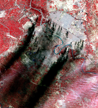
On Monday March 31, the Moderate Resolution
Imaging Spectroradiometer (MODIS) on the Terra satellite captured this image
of Baghdad. The smoke plumes, which originate along major roads and canals,
are believed to be burning pools of oil from pipelines. Bill Mahler of Wild
Well Control Inc., a company fighting the oil well fires in the south, explains
that these fires in Baghdad will most likely be allowed to burn. "It's
environmentally better if it burns off, otherwise if it doesn't the oil could
migrate through the soil into the water table." NASA/GSFC/MITI/ERSDAC/JAROS,
and U.S./Japan ASTER Science Team.
Thomas Ahlbrandt, chief of the U.S. Geological Survey (USGS) World Energy Project
in Denver adds, “Bergan is the second largest oil field in the world. It
had drastic reductions, but the damage was not as bad as was originally thought.”
The loss of oil and gas from the oil reserve in these southern Iraqi fields,
which contain between 500 and 600 oil wells, has yet to be determined. But some
are concerned that the damage may be greater than just the oil lost to the flames.
Petroleum engineer Mahendra Verma of USGS in Denver explains that burning oil
at the surface can reduce underground pressure. High pressures are needed during
drilling operations to bring oil to the surface. “It is hard to give a
quality estimate of the damage,” Verma says. “Oil and gas is a valuable
commodity; damaging the reservoir, which is the source of oil and gas, creates
a problem for a long time to come.”
However, multiple factors indicate Iraq will have a significant oil supply for
years into the future. Prior to the war, the southern Rumaila fields had produced
8 billion barrels of oil, Verma says, leaving an estimated 22 billion barrels
still in the reserve. The East Baghdad oil field has an estimated 16 billion
barrels in place, but little so far has been produced. For comparison, the United
States itself has about 22 billion barrels of oil reserves in the country, he
adds.
In addition, Iraqi oil is also considered a light oil, with a high gravity index
that reflects greater gas content (between 35 and 40 API, American Petroleum
Institute). Because of the gas, light oil has a naturally higher pressure that
aids its extraction. In comparison, the heavier crude oil typically found in
the United States has a low gravity index (between 15 and 25 API).
As for the concern over the potential loss of pressure from the recent fires
in Southern Rumaila, marketing manager Bill Mahler of Wild Well Control Inc.,
considers it, “very, very negligible.” Wild Well is one of two companies
subcontracted through Kellogg Brown & Root (KBR), a subsidiary of the Halliburton
Co., to extinguish the flames.
When Iraqi wells began burning, the Department of Defense designated the Army
Corps of Engineers as the executive agent to oversee putting out the fires.
The Corps of Engineers turned to KBR because of a contract signed years earlier
that put KBR personnel in the region. The Army Field Support Command’s
Logistics unit had requested KBR pre-position people and equipment in Kuwait
back in December 2001. “That’s why they were sole-sourced for our
contract because they were there,” explains spokesman Scott Saunders of
the Army Corps of Engineers. “They were the only contractor in the area
that had the means to get to those fires quickly.” On April 13, almost
a month after Iraqi forces first ignited their own oil wells, KBR oversaw capping
of the last burning oil well in the Southern Rumaila oil fields.
Christina Reed
Back to top
Navigating
dust: 21st-century warfare and the sandstorms of Iraq
The weather has proven to be a formidable enemy in the war in Iraq. Even in an
age of satellite-guided munitions, severe storms still present a major roadblock
for military action.
 Most dramatic are
the sandstorms, walls of dust and debris moving across the desert and through
cities, wreaking havoc on military equipment and personnel. On an individual level,
the particles can lead to hacking coughs, disorientation and an inability to see
targets. On a machine level, storms can disable engines on both aircraft and rockets,
block infrared and laser targets, and reduce pilot visibility to nearly zero.
Most dramatic are
the sandstorms, walls of dust and debris moving across the desert and through
cities, wreaking havoc on military equipment and personnel. On an individual level,
the particles can lead to hacking coughs, disorientation and an inability to see
targets. On a machine level, storms can disable engines on both aircraft and rockets,
block infrared and laser targets, and reduce pilot visibility to nearly zero.
In winter, the Mediterranean Sea surface temperatures are warmer than surrounding
land temperatures, creating a semi-permanent, low-pressure system that pulls cool
air from Europe and warm, dry air from North Africa.
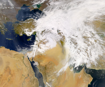
This true-color SeaWiFS image shows the
counterclockwise swirl of a low-pressure system over the Middle East on the morning
of March 26, 2003. The system appears to be scooping up dust (light brown pixels)
from the deserts beneath it and pushing the dust toward the southeast. Image courtesy
of SeaWiFS Project, NASA/Goddard Space Flight Center, and ORBIMAGE.
"These are the classic conditions for the development of storm fronts,"
Wallis says.
Every three to five days, a frontal system breaks away from the Mediterranean
air mass and travels east.
The storms bring rain to the mountains of Turkey and Iran, while the lower elevations
of Jordan, Iraq and northern Saudi Arabia are hit with a dry wind dominated by
the Saharan air.
"The change can be dramatic," Wallis says, "from light to moderate
southwesterlies to strong and gusty northwesterly winds, commonly called the Shamal.
The winds grow as they channel between the Turkish and Iranian Mountains and the
high Saudi Plateau, and turbulence increases as the air rushes over the relatively
warm land surface.
"It can go down to nothing and then suddenly up to 40 mph," Wallis says,
"very, very gusty." Winds are especially severe in March and April as
the ground warms, creating more convection and instability, and producing thunderstorms
with extremely strong winds.
Southwest Iraq is dominated by a dusty desert, as opposed to the coarser and sometimes
rocky materials of Saudi Arabia and some of the other regions in the Middle East.
The fine sediment is easily caught up by the storm fronts. After the systems reach
the Persian Gulf, the dust can drop out and the air may pick up moisture, producing
thundershowers that often have much lightning, but little rain.
"In what looks like a violent thunderstorm, you can almost walk between the
drops," Wallis says. "And if it is dusty, the rain drops are muddy.
When you get it on your clothes it's yellow — it stains quite a bit. The
dust gets everywhere too. It doesn't matter how airtight you think your house
is, it still gets in — into your food, eyes and nose. It is very unpleasant."
Sandstorms also arise in the summer, mainly in July. However, the weather situation
is different, dominated by the South Asian monsoon trough as it gradually extends
over Iran.
Says Wallis: "This produces what the locals call a 40-day Shamal," an
event which actually lasts anywhere from 30 to 50 days. The winds are not as violent,
but they are persistent, dusty and dry, although he concedes, "the dry wind
actually makes the summer temperatures a little more pleasant."
"From a military point of view, it is clear that the U.S. Air Force wants
to 'own the weather' just as they now 'own the night,'" says Thomas Schnell
of the Operator Performance Laboratory at the University of Iowa. He is one of
the researchers developing technologies to help pilots "see" the world
around them under any conditions.
Schnell, also a pilot, and his colleagues at Iowa, the U.S. Air Force, NASA and
Rockwell Collins Inc., are developing synthetic and enhanced vision for aircraft.
Synthetic Vision Information Systems (SVIS) combine 3-D elevation models (accurate
to global positioning system coordinates),
information from inertial navigation systems, and computer rendering techniques
to re-create the environment around an aircraft.
“It’s basically like moving a camera through a 3-D world,” Schnell
says. “What you see is not a sensor-derived image, like night vision.”
Instead, by using a combination of position and environment data and satellite
imagery, the pilots can visualize surroundings that are otherwise obscured. The
ultimate goal is to use the technology along with sensor information, such as
infrared or millimeter-wave radar, to cross-check the synthetic terrain information.
“To validate the synthetic view, you need to have a second opinion, so to
speak,” Schnell says.
Some technologies for using ground vehicles in desert weather have been in use
for several decades. John Wiss of Carnegie Mellon University is a leading expert
in maintaining armored vehicle engines. In the 1960s, Wiss was an active- duty
Army officer and director of the Army Tank-Automotive Laboratories in Detroit.
One of the technologies arising from the unit’s research was the two-stage
air cleaner still used in U.S. armored vehicles.
“The engine breathes a continuous stream of clean air,” Wiss says, “no
matter how dirty the incoming air might happen to be.” However, the recent
conflict arose during Iraq’s peak sandstorm months, and in spite of such
capabilities, the harsh weather still hampered aircraft and troop movements. Sandstorms
in Iraq are both winter (December through April) and summer phenomena, and a severe
March storm delayed many military flights for days.
“The upper trough of that storm was deeper than I ever remember,” says
Trevor Wallis, a Middle East weather expert at the National Oceanic and Atmospheric
Administration, who spent more than a decade living and teaching in the Middle
East and was impressed by the winter storm.
The enhanced vision capabilities will not be fully operational and deployed for
a number of years. Although civilian and military pilots have already tested the
technology, the system is still in development stages.
Schnell’s team is concentrating on creating the ideal visual interface for
the pilot, while other researchers are addressing such concerns as how to rapidly
update synthetic terrain information. While less of a concern for the technology’s
potential civilian aircraft uses, the changing landscapes of dynamic terrains,
such as the shifting dunes of the desert, pose operational problems for keeping
the system updated. In addition to landing in the right spot, “you want to
avoid flying a perfectly good airplane into a perfectly hard mountain,” Schnell
says.
Piloting in any flyable weather, regardless of visibility conditions, is a “definite
goal” for the technology, he says. Some aircraft systems may be affected
by harsh conditions such as blowing dust and debris. “However, with regard
to sandstorms, the synthetic vision system does not care about them,” Schnell
says. “It works in any weather.”
Josh Chamot
Geotimes contributing writer
Back to top
