Geotimes

Feature
Hijacking the Rio Grande: Aquifer Mining in
an Arid River Basin
Lisa Robert
Sidebar: Water
management microcosm
 In December
2002, the U.S. Geological Survey published a map of groundwater declines in
the Albuquerque basin of central New Mexico. For those who live in the rapidly
urbanizing Middle Rio Grande corridor, the map’s message is not good: Several
severe “cones of depression” are evident in the prime Santa Fe Group
aquifer, from which more than half a million people get their drinking water.
The deepest wound lies beneath eastern Albuquerque; two others mark the city’s
developing western side and the rival metropolis Rio Rancho on the high ground
to the north.
In December
2002, the U.S. Geological Survey published a map of groundwater declines in
the Albuquerque basin of central New Mexico. For those who live in the rapidly
urbanizing Middle Rio Grande corridor, the map’s message is not good: Several
severe “cones of depression” are evident in the prime Santa Fe Group
aquifer, from which more than half a million people get their drinking water.
The deepest wound lies beneath eastern Albuquerque; two others mark the city’s
developing western side and the rival metropolis Rio Rancho on the high ground
to the north.
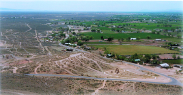
Stark contrast marks the edge of the Rio Grande floodplain south of Los Lunas,
N.M., where irrigated farmland meets arid high ground that is awaiting development,
with an uncertain future. Photo by Peter Hebard.
Those bull’s eyes in the water table have relevance for river basins throughout
the arid Southwest, where surface flow and groundwater often maintain a tenuous
but vital connection. Understanding that link is crucial to resolving future
water conflicts in the region.
A hydrologic fundamental
The Rio Grande splits New Mexico roughly in half. Midway on its journey from
the southern Rockies to the Gulf of Mexico, the river flows through a series
of basins known as the Rio Grande Rift, a 30-million-year-old stretch mark in
the planet’s crust. Thanks to the work of water, this great rift has slowly
filled with layers of gravel, sand and clay. In some places, the deposited sediment
is 15,000 feet thick.
In the upper several hundred feet of sediment, river and groundwater are virtually
one; like any stream, the Rio Grande runs not only in its channel, but also
into every cavity below and adjacent to its bed. The water accommodates an infinite
number of natural “users,” including permeable soils, the dry desert
air, and all manner of flora and fauna. As New Mexico consulting hydrologist
and teacher John W. Shomaker explains: “One might entertain the idea that
a river only exists as a residual. It is the water allowed to stay on the ground
after recharge and evapo-transpiration have taken their share. The river is essentially what is left
over.”
Scientists once believed that the Albuquerque basin housed a subterranean “Lake
Superior.” In the late 1990s, however, geologists learned that complex
faulting, volcanic intrusions and layers of clay isolate portions of the aquifer
and limit their interaction with the surface. These amputated deposits of archaic
water are finite and irreplaceable, meaning the basin contains much less high-quality
groundwater than was originally supposed. Moreover, booming municipalities such
as Albuquerque and Rio Rancho currently derive all of their drinking water from
the ground, and are pumping it out faster than rain and runoff can replenish
it. For the river, tasked with serving all thirsts, and for everything that
relies on the “residual” Rio Grande, a calamity is in the making.
Water on paper
Across the West, two rules have prevailed for more than a century: Whoever claimed
the water first has priority in times of shortage, and water must be put to
beneficial use or the right to it is forfeited. In the Rio Grande valley —
the oldest continuously irrigated region in North America — the earliest
rights belong to Native American pueblos and tribes that lived along the river
and its tributaries before the arrival of Europeans around 1600. Second in seniority
are rights derived from New Mexico’s Spanish colonial time. About a thousand
community ditches built by Hispanic settlers are still in use, and many others
have been superseded by modern conveyance systems based, in part, on old water
rights.
The federal government recognized these rights by treaty in 1848. New Mexico’s
territorial government did likewise in 1907, when senior status was granted
to all existing water uses. After 1907, appropriations of surface water required
a permit from the state, and priority was established according to the application
date. Most of the rights belonging to municipalities fall into this “junior”
category.
The state has legally acknowledged the connection between surface flow and groundwater.
Where potential exists for groundwater pumping to deplete a stream system, the
state may prohibit or limit groundwater withdrawals; it did exactly that in
the Albuquerque basin in 1956. Surface rights must be purchased and “retired”
in exchange for what is pumped from the new well. The rule applies only to large
wells; domestic wells are considered de minimus depletions of groundwater and
are exempt from the offset requirement, despite the fact that several thousand
additional permits are issued by the state every year. The cumulative impact
of domestic wells on the system may be anything but ancillary: No one knows
how many are in use in the basin, or how much water they extract, because metering
is not compulsory.
Additionally, the Rio Grande is subject to an interstate compact that apportions
annual flow between the states of Colorado, New Mexico and Texas, as well as
an international treaty that allocates 60,000 acre-feet (more than 19 billion
gallons) of water to Mexico every year. After nearly a century, these arrangements
seem inherently flawed. The rights of Native Americans were recognized but not
delineated, and no water was set aside for river ecosystems. Yet today, federal
laws, such as the Clean Water Act and the Endangered Species Act, require minimum
flows for the dilution of treated wastewater and for species habitat, leaving
management agencies and water rights holders to try and meet the mandates.
Thanks to yet another interstate agreement, however, the Rio Grande has had
the benefit of a cushion for the past 30 years. New Mexico is entitled to a
little over 11 percent of the flow of the upper Colorado River because a tributary,
the San Juan River, loops through the northwestern corner of the state. Beginning
in 1972, up to 96,000 acre-feet (about 31 billion gallons) of San Juan water
has been re-routed into the Rio Grande basin via tunnels blasted through the
Continental Divide by the U.S. Bureau of Reclamation. Specific amounts of the
imported supply are contracted to the city of Albuquerque, to the Middle Rio
Grande Conservancy District for irrigators in the middle valley, and to numerous
other entities. Through the marvel of engineering, one drainage basin is now
dependent upon water requisitioned from another.
Reality check
In the late 1990s, hydrologists generated a budget of inflows and outflows to
aid water planners in the Middle Rio Grande. The reckoning calculated that in
spite of combined native and imported flows, the region is racking up a deficit
of between 55,000 and 70,000 acre-feet a year.
Three things have allowed the region to carry such a debt without running afoul
of the Rio Grande Compact. First, there have been annual transfusions of water
from the San Juan. Second, municipalities have been pumping ancient groundwater
from the basin aquifer and returning half of it to the river as treated discharge.
Third, the past 20 years have not been average in terms of precipitation; they
are among the wettest on record in the desert Southwest.
Metropolitan growth has piggybacked on these three windfalls, but now events
are conspiring to call in the region’s overdue loans. New Mexico appears
to be entering a phase of long-term drought. Climatological research, archaeological
evidence and tree ring data from the past several millennia all testify to cycles
of severe aridity in the southwestern United States, lasting anywhere from a
couple of decades to hundreds of years. Were such conditions to occur today,
they would equally affect water supplies in the Rio Grande drainage basin and
in the neighboring San Juan River basin.
Yet development is accelerating in the river corridor, and municipalities are
scrambling to find water to meet projected future demand. Albuquerque plans
for direct use of its San Juan allocation for municipal consumption. In order
to reduce reliance on the aquifer, the city hopes to divert as much as 103,000
acre-feet of water a year from a 17-mile stretch of the Rio Grande. Although
the city would return half that amount to the river downstream, the diversion
would greatly diminish flows in the reach where the worst drawdowns occur in
the water table. The city employed a flow model, developed by contractors, to
assess project impacts indicates that even if groundwater pumping were to cease
completely, the aquifer would not be able to recover within 60 years. Meanwhile,
without some curb on growth, the city will again exhaust the water rights it
owns and resume full-time groundwater mining, perhaps in as little as two decades.
Calculating the losses
Conventional thinking advocates funding urban expansion with water derived
from agriculture. Through advanced methods of water conservation and application,
and through the attrition of farmland, water is “freed up” and reallocated
to the “highest and best use,” which is assumed to be residential
and commercial development. But, a different future may be unfolding.
Where dams and leveed channels have regulated and contained rivers and streams,
irrigation preserves the vital link between surface flow and aquifer. Irrigation
in the Albuquerque basin offers a good example of such artificial connection.
According to a 1997 Bureau of Reclamation study, 50 percent of groundwater recharge
occurs through flood irrigation and seepage from canals and drains that parallel
the river. But concentrated aquifer pumping, urban sprawl across upland recharge
zones, and the simultaneous retirement of irrigated bottomlands are drying out
the basin sponge; once dry, it may be impossible to resaturate.
In the Middle Rio Grande, the attrition of irrigated land is at work with an
added twist. Acre by acre, as water rights are transferred from farms on the
valley floor, suburban homes are built on the retired land. Most draw water
from private wells, sucking from the ground (and thus from the river) the same
amount of water sold off as surface rights to supply development elsewhere.
Equally damaging, the state has been granting pumping permits to developers
on the condition that offset rights will be obtained from an unspecified source
at some unspecified time in the future. Together these two policies have resulted
in a gross over-appropriation of the Rio Grande. Former State Engineer Thomas
C. Turney has estimated that paper claims outstrip wet water in the basin by
a factor of four to one.
In a stream system where more uses are being approved than can actually be served,
those who hold unquantified senior rights have plenty to fear. New Mexico law
insists that the state apportion water according to priority in times of shortage,
but determining entitlements is a slow, expensive and contentious process, and
most of the state’s Native American and early agricultural rights have
not been adjudicated.
In the meantime, powerful development and municipal interests continue to lobby
for political decisions based solely on “economics,” and state officials
hint that in the future, there may be no such thing as senior rights. Everyone,
they say, will simply have to share. That approach threatens both treaty promises
and compact obligations. It also fails to acknowledge the combined effects of
long-term drought, ever-increasing numbers of water users, and a river taken
hostage by its aquifer. Given such impending circumstances, the future may well
consist of a panorama of abandoned subdivisions above a dusty floodplain.
Unexpected paradigm
Arranged in a semicircle around Rio Rancho and Albuquerque are four Indian pueblos:
Zia (see sidebar), Santa Ana, Sandia and Isleta. Sandia
and Isleta bracket the area of greatest aquifer decline. And while Albuquerque’s
pavement and concrete obscure the geology of piedmont slope and floodplain,
the adjacent pueblos constitute a partial preserve of natural drainage and recharge.
They offer the only places in the urban corridor where ribbons of undeveloped
land stretch from mountain front to river. The immense value of those intact
watersheds has yet to be recognized.
With tribal rights unquantified, and junior users proliferating all around them,
Sandia, Isleta and Santa Ana are each developing commercial and recreational
complexes, including resorts, casinos, golf courses and soccer fields. The volume
of water required to maintain such facilities in the high desert raises ethical
issues, but the pueblos are simply putting quantities of water to use as a hedge
against otherwise certain loss.
Fortunately, tribes are also starting to explore more system-friendly options.
All three of the urban corridor pueblos are involved in river restoration efforts
and endangered species recovery programs that depend primarily on improving
hydrologic function. Projects to enhance overbank flooding, revive river channel
dynamics, reestablish wetlands, remove non-native vegetation and assure watershed
health, through better forest and range management, could someday become more
economically rewarding than development that encroaches on a tapped environment
and historic water rights. If so, hydrologic guardianship of the Middle Rio
Grande may not be far behind.
| Water management
microcosm
The Pueblo of Zia, which has occupied its present site on the Jemez River
since around A.D. 1200, is devoted to preserving its heritage. Its menfolk
still hunt to fill family freezers with deer, elk and turkey. Feast day
dances are respectfully performed. Most residents practice at least one
traditional craft, and a tribal project to perpetuate the native language
has been underway for some years.
“There will never be a casino at Zia,” says Governor Peter Pino,
who served as tribal administrator for 31 years before accepting the governorship
of the pueblo last December. One of the state’s most proactive tribal
leaders, Pino has been instrumental in helping his pueblo choose a responsible
path, particularly regarding water.
Zia’s efforts to make modern economic decisions that have minimum
impacts to the environment may have begun in 1977, when the tribe acquired
White Mesa, a striking outcrop of Todilto limestone southwest of the pueblo
that was being mined for gypsum. Today, gypsum is still being extracted
and processed at a plant in nearby Bernalillo, but Zia’s lease agreement
calls for reject sheetrock and wallboard to be returned to the extraction
area, to be recycled by the elements.
Water’s scarcity and sacredness is at the heart of Zia life. With
the ephemeral Rio Jemez on their doorstep, tribal elders pay close attention
to the natural hydrologic cycle, trekking into the mountains each spring
to assess the snowpack and authorizing a corresponding number of pueblo
croplands to be planted for the coming growing season. In wet and dry
years alike, water is strictly rationed — Zia permits no landscaping,
groundwater is used only for household needs, and trucks and cars wear
proud coats of dust.
Since 1983, a water rights adjudication suit has been underway in the
Jemez basin. Although the process is seldom conducive to neighborliness,
when drought threatened the drainage’s residents in 1996, Pino and
the leaders of five upstream agricultural communities pioneered a “shortage
sharing” agreement based on an early precedent involving Zia and
the Village of San Ysidro. The current pact, officially adopted as part
of the ongoing adjudication, recognizes the senior water rights of both
Zia and the Pueblo of Jemez, but outlines a series of schedules whereby
wet water may be amicably distributed to junior users of the Rio Jemez.
In the arena of regional water planning, which the New Mexico legislature
mandated in 1997, Zia’s voice has also been heard. In the only state
with no legal protection for instream flow, the first principle of the
Rio Puerco/Rio Jemez subregional plan honors the pueblos’ spiritual
need to leave a little water in the river.
But conflicts over that limited resource are far from settled, and once
again, Zia is on the front line. Just across U.S. Highway 550 is the creeping
edge of Rio Rancho, one of the fastest growing cities in the Southwest.
In order to pump additional groundwater to serve its teeming newcomers,
Rio Rancho must acquire and “retire” surface water rights (see
main story).
Aware that any reduction in irrigated land could negatively affect the
flow of the Jemez, Zia filed a lone protest of Rio Rancho’s proposed
transfer of 124 acres of agricultural water rights from the Village of
San Ysidro, six miles upstream from the pueblo. The protest seeks to remind
municipal and state administrators that the 1996 agreement between Jemez
basin pueblos and non-Indian irrigators still stands, and that any rural/urban
water transfers will be subject to the terms of the shortage sharing schedule.
Zia’s challenges frame a major dilemma for the modern Southwest:
a choice between a future driven by rampant growth or by an obligation
to hydrologic reality.
LR
|
A lifelong resident of the Middle
Rio Grande, Robert is a freelance writer who has concentrated exclusively on water
issues for the past 17 years. She is the former editor of the New Mexico Water
Dialogue and currently publishes a newsletter for constituents of the Middle
Rio Grande Conservancy District. She is also sole indentured servant to a 5-acre
farm near Tomé, in the floodplain of the Rio Grande.
Suggested Reading:
Bauer, Paul W., Richard P. Lozinsky, Carol J. Condie, and L. Greer Price. 2003.
Albuquerque: A Guide to Its Geology and Culture. Scenic Trip Series,
No. 18. New Mexico Bureau of Geology & Mineral Resources, Socorro, N.M.
Bexfield, Laura M. and Scott K. Anderholm. (2002) Estimated Water-Level
Declines in the Santa Fe Group Aquifer System in the Albuquerque Area, Central
New Mexico, Predevelopment to 2002. U.S. Geological Survey Water Resources
Investigations Report 02-4233.
Briggs, Mark K. 1996. Riparian Ecosystem Recovery in Arid Lands: Strategies
and References. University of Arizona Press, Tucson, Ariz.
Johnson, Peggy S., Editor. 2003. Water, Watersheds, and Land Use in New
Mexico: Impacts of Population Growth on Natural Resources. New Mexico Decision-Makers
Field Guide No. 1.
New Mexico Bureau of Mines and Mineral Resources, Socorro, N.M.
Postel, Sandra and Brian Richter. 2003. Rivers for Life; Managing Water
for People and Nature. Island Press, Washington, D.C.
Back to top
