
Geotimes Home | AGI Home | Information Services | Geoscience Education | Public Policy | Programs | Publications | Careers
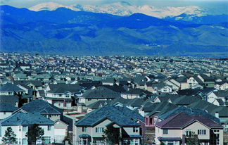 In 1970,
12,000 people lived in Douglas County, Colo., just south of Denver. Today, more
than 200,000 people reside there, with the population expected to double in the
next 25 years. Like other counties in the Denver area, Douglas relies on 10,000-year-old
groundwater from bedrock aquifers located in the Denver Basin for its water supply.
The rapidly growing population, however, is sucking the supply dry.
In 1970,
12,000 people lived in Douglas County, Colo., just south of Denver. Today, more
than 200,000 people reside there, with the population expected to double in the
next 25 years. Like other counties in the Denver area, Douglas relies on 10,000-year-old
groundwater from bedrock aquifers located in the Denver Basin for its water supply.
The rapidly growing population, however, is sucking the supply dry. 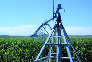 The High Plains
aquifer spreads below 111 million acres of land, encompassing eight states, and
waters the nation’s breadbasket. Since the 1940s, widespread groundwater
pumping from the aquifer for irrigation has led to the annual production of millions
of tons of corn, winter wheat, sorghum and other crops that feed cows and people
around the world. But the water resource is rapidly dwindling, threatening the
livelihood of the western states that rely on the High Plains aquifer for domestic,
agricultural and ecosystem water.
The High Plains
aquifer spreads below 111 million acres of land, encompassing eight states, and
waters the nation’s breadbasket. Since the 1940s, widespread groundwater
pumping from the aquifer for irrigation has led to the annual production of millions
of tons of corn, winter wheat, sorghum and other crops that feed cows and people
around the world. But the water resource is rapidly dwindling, threatening the
livelihood of the western states that rely on the High Plains aquifer for domestic,
agricultural and ecosystem water. |
Geotimes Home | AGI Home | Information Services | Geoscience Education | Public Policy | Programs | Publications | Careers |