
 New mineralogical
data and pictures of landforms on Mars are streaming in from instruments aboard
the European Space Agency’s Mars Express Orbiter. The new data show that
Earth’s rocky neighbor once had a lot of water — but various interpretations
of the data differ on when and where that water may have been (and may still
be). Any resolution may require a major shift in thinking about Mars’ water
cycle.
New mineralogical
data and pictures of landforms on Mars are streaming in from instruments aboard
the European Space Agency’s Mars Express Orbiter. The new data show that
Earth’s rocky neighbor once had a lot of water — but various interpretations
of the data differ on when and where that water may have been (and may still
be). Any resolution may require a major shift in thinking about Mars’ water
cycle.
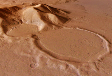
This perspective image from the Mars Express High-Resolution Stereo Camera shows
an hourglass-shaped set of craters that researchers say have flow lines, which
could be traces of glacier activity. The image is part of a new dataset indicating
active water at Mars’ surface. Image courtesy of ESA.
Mars Express’ OMEGA, a sensitive high-resolution, near-infrared imaging
instrument, has seen what previous instruments could not resolve. Published
in the March 11 Science, researchers have created a mineralogical map
of sorts, translating OMEGA’s signals into olivine-rich outcrops and pyroxene,
minerals that require liquid water to form. They also found “hydrated”
minerals that contain water, as well as sulfate deposits that may have formed
in water and are possibly part of the same formation identified by the rover
Opportunity, 400 kilometers away. These once-buried minerals are quite old,
according to dates provided by comparison with impact craters.
But the team says that if Mars was wet and warm, it was very early in its history.
“We do not have evidence for a wet Mars in the past 3.5 or 4 billion years,”
says team leader Jean-Pierre Bibring of the Institut d’Astrophysique Spatiale
in Paris. The only actual water OMEGA detected directly was not fluid but was
frozen in the polar ice caps and coated in carbon dioxide ice. Any more recent
fluid activity, the team suggests, could be affiliated with volcanic outbursts,
acidic snowfall or periodic glacial melting governed by changes in Mars’
orbital orientation.
The complexity of that history is indicated by another “important result”
from OMEGA, says David Paige of the University of California at Los Angeles
(who wrote an accompanying comment in Science). OMEGA’s observations
show “fine-scale diversity” and broad distribution of rocks across
Mars, even though it has “seen” only half the planet so far.
But new images from another instrument on Mars Express, the High-Resolution
Stereo Camera, have led another team, publishing in the March 17 Nature,
to interpret some deposits as the result of large-scale flooding only a few
million years ago. A large release of fluids in a volcanic event could have
flooded an area the size of the North Sea, leaving rafted deposits behind to
cover up a frozen sea beneath.
The presence of a frozen sea is hotly debated. Paige says that even though remote-sensing
techniques cannot see everything, “we don’t have evidence for a giant
ocean.”
Still, says Vic Baker of the University of Arizona at Tucson, who wrote a comment
accompanying the Nature papers, “the landforms are there; you can’t
ignore them and they don’t go away.” Ultimately, Baker says the debate
is “going to be solved only by direct detection of ice preserved at the
site.” Scientists eventually may have to reconcile the battling Mars Express
data by determining whether Mars has a very different water cycle than Earth’s.
“It’s exciting science,” Baker says, “like pre-plate tectonics”
science on the verge of a major shift.
Naomi Lubick
Back to top
 |
Geotimes Home | AGI Home | Information Services | Geoscience Education | Public Policy | Programs | Publications | Careers |