
From the August 1980 Geotimes:
 After 7 weeks of steam-venting, phreatic eruptions and accompanying seismic activity, Mount St. Helens volcano in southwestern Washington erupted catastrophically May 18. Apparently triggered by the first of 2 magnitude-5 earthquakes (at 0832 and 0834 Pacific Daylight Time), the upper north flank, which had bulged outward as much as 125 meters, gave way in an immense landslide, instantaneously releasing the pressure on a plug of a gas-charged dactic magma that had risen to possibly the 1,200-meter level inside the volcano.
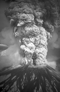
The eruption of Mount St. Helens on May 18, 1980, sent volcanic ash, steam, water and debris to a height of 60,000 feet. The plume moved eastward at an average speed of 60 miles per hour, with ash reaching Idaho by noon. The mountain lost 1,300 feet of height. (Austin Post/USGS)
The shock wave created by the explosion passed over near-lying communities but shook mountain climbers above the 1,500-meter elevation on Mount Adams and other dormant Cascade volcanoes and was felt at Vancouver, B.C., in eastern Washington and Oregon, and in the Willamette Valley to the south at 200 to 400 kilometers away. Aerial observers were, surprisingly, unrocked by the explosion, strengthening the belief that the force of the eruption was directed horizontally.
The initial blast of incandescent gas and ash vented sub-horizontally to the north through the upper part of the descending landslide. Traveling at a velocity estimated at 50 meters per second, it devastated within minutes an area of 500 square kilometers, toppling trees and stripping the nearer ones of bark and foliage, and burning and choking people caught in its path. Pumice and lithic fragments were imbedded in trees and in the upturned stumps and roots of flattened trees. Grey ash thinly covered the ravaged surface, flowed down drainages, and filled depressions up to 1 meter deep. The blast, with temperature estimated at 200 degrees Celsius, was hot enough to scorch (but not char) trees 30 kilometers from the volcano.
 The landslide, mixed with pyroclastic debris and forming a mass 2 to 3 cubic kilometers in volume, pummeled the lower northern slope of the volcano, plunged into Spirit Lake 8 kilometers north-northeast of the crater, and surged north-northwestward about 20 kilometers down the North Fork of the Toutle River, filling the valley to a depth of 60 meters.
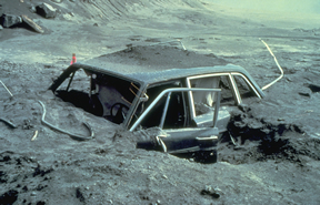
Approximately 10 miles from Mount St. Helens, a giant flow of mud and debris buried this car, which was owned by Reid Blackburn, a photographer for National Geographic and Vancouvers The Columbian newspaper who was killed in the May 18 eruption. (Dan Dzurisin/USGS)
Within a few minutes, the horizontal blast dissipated, and the eruption concentrated in a vertical column that gradually rose within an hour to over 13 kilometers in elevation. The column remained 13 to 19 kilometers high for about 9 hours, dropped lower during the next 3.5 hours, and by May 19 had diminished to steam jets.
Prior to its eruption in 1980, Mount St. Helens towered at 9,680 feet and had not erupted since the 1800s. According to the U.S. Forest Service, Mount St. Helens and the Spirit Lake Basin area had more than half a million visitors in 1979.
 Almost five years prior, in 1975, U.S. Geological Survey (USGS) geologists Dwight Crandell and Donald Mullineaux and geochemist Meyer Rubin warned in Science magazine that “an eruption is likely within the next hundred years, possibly before the end of this century.” Crandell and Mullineaux further assessed the risks at Mount St. Helens as part of a USGS systematic evaluation of volcanic hazards in the Cascades in 1978. Their report described the volcano as “more active and more explosive during the last 4,500 years than any other volcano in the conterminous United States,” and they mapped out hazard zones for various types of future ashfalls, lava flows, pyroclastic flows, mudflows and floods.
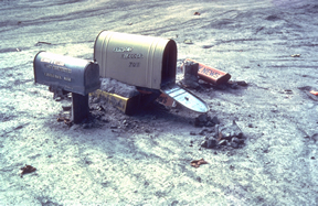
A mudflow from Mount St. Helens eruption on May 18, 1980, buried mailboxes along the Cowlitz River, shown here in July 1980. (Lyn Topinka/USGS)
During and following this work, USGS scientists and others began looking at ways to monitor the volcano for signs of an eruption. But because of limited knowledge of the Cascade volcanoes’ geologic history, it was difficult to choose a reliable approach. Early monitoring included use of seismometers, ground-surface measurements, aerial infrared surveys and surface temperatures, as well as regularly taken photographs.
At the beginning of March 1980, when the first signs of unrest began, the only instrument directly monitoring Mount St. Helens was a seismometer on the western flank of the volcano. That month, earthquakes, ground deformation and steam explosions continued for nearly two months before culminating in the major eruption in May.
On the morning of May 18, a magnitude-5.0 earthquake rocked Mount St. Helens, and the north side of the summit began to slide down the mountain. Following the giant landslide of rock and ice was an enormous explosion of steam and volcanic gases, which traveled northward along the ground at high speed. The landslide debris surged down the volcano at speeds in excess of 100 miles per hour (see description above). Ash from the eruption fell like snow on cities and towns in the Pacific Northwest and drifted around the planet within two weeks. The eruption ultimately killed 57 people, and devastated 210 square miles of wilderness area.
Mount St. Helens produced five smaller explosive eruptions during the summer and fall of 1980 and continued its activity until another eruption in 1986. The volcano reawoke in September 2004 and has been effusing lava ever since, but scientists say that it is unlikely that the next eruption of Mount St. Helens will be as explosive as the one in 1980.
Benchmarks was compiled by Lisa M. Pinsker, using information from the U.S. Geological Survey, historychannel.com and past coverage in Geotimes. See the March 2005 Geotimes for more on Mount St. Helens’ recent activity.
 |
Geotimes Home | AGI Home | Information Services | Geoscience Education | Public Policy | Programs | Publications | Careers |