
 On
March 28, a magnitude-8.7 earthquake shook the southern part of Sumatra on a piece
of fault that had been put under greater stress by last December’s much larger
earthquake. But while a magnitude-8.7 temblor is large by any metric, the event
did not create a massive tsunami. The difference, geologists say, lies in the
geography and other geologic factors.
On
March 28, a magnitude-8.7 earthquake shook the southern part of Sumatra on a piece
of fault that had been put under greater stress by last December’s much larger
earthquake. But while a magnitude-8.7 temblor is large by any metric, the event
did not create a massive tsunami. The difference, geologists say, lies in the
geography and other geologic factors. 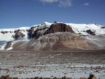 Frozen
ground is no surprise at Earth’s poles. In the Arctic, permafrost consists
mostly of frozen soil and rock, up to several meters thick, with some ice layers.
In the Dry Valleys of the Antarctic, however, permafrost often seems to be thick
layers of ice, covered by layers of thin till that are generally only several
centimeters thick. These tongues of ice seem to be remnants of glaciers from
neighboring valleys. Still, ice in the Dry Valleys appears not to have moved
for a long time, and researchers are trying to determine exactly how dynamic
the ice system may be.
Frozen
ground is no surprise at Earth’s poles. In the Arctic, permafrost consists
mostly of frozen soil and rock, up to several meters thick, with some ice layers.
In the Dry Valleys of the Antarctic, however, permafrost often seems to be thick
layers of ice, covered by layers of thin till that are generally only several
centimeters thick. These tongues of ice seem to be remnants of glaciers from
neighboring valleys. Still, ice in the Dry Valleys appears not to have moved
for a long time, and researchers are trying to determine exactly how dynamic
the ice system may be.
Beacon Valley is one of the Antarctic’s
so-called Dry Valleys, which have very little precipitation and are some of
the only ice-free regions on the continent. But the ice beneath the glacial
till that carpets these valleys may be more dynamic than it looks. Photo by
Ron Sletten.
Very little precipitation falls in these valleys, in a region that is so dry
that the ice is constantly sublimating — basically evaporating molecule
by molecule, without turning to water first. Also, the valleys are patterned
by polygon-shaped stress cracks, which form to relieve stress as temperatures
fall and the ground contracts, in much the same way columnar basalt or mud cracks
form elsewhere.
 These
cracks commonly fill with water in spring in the Arctic, or ice wedges in winter,
but in the Antarctic, they fill with windblown silt and sand, says Ron Sletten
of the University of Washington, Seattle, a co-author of new research looking
at the activity of ice in the Dry Valleys. Sletten and colleagues worked with
modeler and mathematician Felix Ng of MIT to redate and model formation of the
till overlying the ice in Beacon Valley. By analyzing previously published “cosmogenic”
helium isotope measurements to figure out how long the rocks have been exposed
to cosmic rays, they found that the till had formed in the past 310,000 to 43,000
years, the team reports in the February Geology.
These
cracks commonly fill with water in spring in the Arctic, or ice wedges in winter,
but in the Antarctic, they fill with windblown silt and sand, says Ron Sletten
of the University of Washington, Seattle, a co-author of new research looking
at the activity of ice in the Dry Valleys. Sletten and colleagues worked with
modeler and mathematician Felix Ng of MIT to redate and model formation of the
till overlying the ice in Beacon Valley. By analyzing previously published “cosmogenic”
helium isotope measurements to figure out how long the rocks have been exposed
to cosmic rays, they found that the till had formed in the past 310,000 to 43,000
years, the team reports in the February Geology.
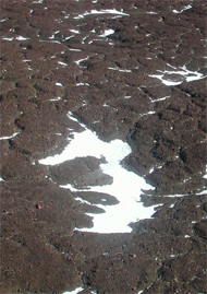
During freezing and thawing cycles in
the Antarctic, permafrost forms pentagon-shaped cracks where windblown silt
deposits. Photo by Ron Sletten.
As the ice sublimates, the rocks and clasts below are brought toward the surface,
forming layers below the till already in place. Their model shows that the rate
of ice sublimation is greater than 7 meters every 1 million years. At that rate,
the ice beneath the rocks and till is probably younger than 1 million years
old, showing a relatively active system for the Dry Valleys.
That rate of sublimation, however, is too fast to fit some previous research,
in which scientists found that one Dry Valley till deposit contained a layer
of ash that dated to 8 million years old. To have ash that old in place would
be evidence for extraordinarily ancient and stable ice beneath it, potentially
containing ancient climate data. But Ng’s model and the team’s redated
rocks — measurements that match most of the rock exposures dated in the
valleys — show that hundreds of meters of ice would have sublimated away
over 8 million years, making it difficult to argue that the ash may still be
in place, they say.
Bernard Hallet, a co-author of the new results, says that “hundreds of
meters of ablation would totally disrupt” the till, mixing the surface
layers. Although the landscape is relatively stable, he says, even with lower
rates of sublimation, there is “enough activity — cracks opening and
closing on a more active surface — where it becomes more difficult to preserve
anything for millions of years.”
But David Marchant of Boston University, who published some of the past research
with colleagues on the ash layer, says that the new dates should be taken as
a minimum possible age of the ancient valley ice, leaving open the possibility
that the ice beneath is much older. He also says that the ash appeared to be
unperturbed in its till layer: “The fact that we can still find areas undisturbed
tells us about the longevity of polygon cracks,” he says, and that ice
has been on the continent for an awfully long time.
Kurt Cuffey of the University of California at Berkeley calls Ng and coworkers’
results “a very solid analysis” that “clearly shows that it’s
not likely that the ice underneath that till can be 8 million years old.”
The amount of sublimation necessary for the ice to be that old may be more likely
to occur on other planets, such as Mars, but “probably not on Earth,”
he says. The larger point remains, however, that old ice still sits in the Antarctic
Dry Valleys, as well as ash layers that have not been transported far, Kuffey
says, which is “good evidence that the Antarctic ice sheet has not overwhelmed
this region in a very long time.”
Naomi Lubick
 |
Geotimes Home | AGI Home | Information Services | Geoscience Education | Public Policy | Programs | Publications | Careers |