
Virginia Beach is Virginia’s coastal playground, replete with long stretches of sandy beaches, a boardwalk teeming with rollerbladers and joggers, and abundant fresh seafood and open pit barbecue restaurants. From the beaches, passersby can occasionally see dolphins frolicking in the Atlantic waves alongside surfers and kids on boogie boards. The city and the surrounding Hampton Roads area are also major residential and business centers, supporting more than 1.5 million residents and the largest military complex in the world.
 But
despite being so enticingly close to a large source of water — the Atlantic
Ocean — Virginia Beach has very little naturally occurring freshwater.
And what little it has is stretching further than ever before, as tourism and
the population continue growing.
But
despite being so enticingly close to a large source of water — the Atlantic
Ocean — Virginia Beach has very little naturally occurring freshwater.
And what little it has is stretching further than ever before, as tourism and
the population continue growing.
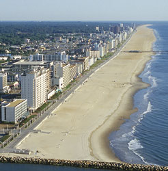
Like many growing coastal cities, Virginia Beach, Va., is having to come up with alternative ways to provide clean water to its growing population, especially in the face of saltwater contamination to its drinking water sources. Image is courtesy of Virginia Beach Tourism.
In addition to these water quantity issues, however, the city has another issue to cope with: saltwater contamination. Salty water has long been encroaching on the region’s groundwater resources and threatens to leave the city with even more freshwater problems. Virginia Beach and other coastal communities recognize this threat and are working toward various solutions.
Population boom
Coastal communities everywhere are growing. By 1995, some 40 percent of the world’s population was living within 100 kilometers of a coast, according to the United Nations. In the United States, that number rises to greater than 50 percent, according to the U.S. Census Bureau. Furthermore, coastal populations are among the fastest growing communities in the nation.
From 1980 to 2003, for example, California’s coastal communities saw an influx of 9.9 million people, or 1,179 more inhabitants every day. Florida’s coastal communities grew by 75 percent over that same time period, and one county, Flagler County, grew by 470 percent. Statistics suggest that overall, coastal communities are not growing significantly faster than noncoastal areas, but because the land area is smaller in coastal regions, the population density is growing substantially.
Many communities that in the past have relied on groundwater from aquifers are being forced now to turn to new options, as they are depleting (or already have depleted) their groundwater resources. The cities of Boston and New York, for example, realized in the 19th century that they did not have the groundwater resources to supply their burgeoning populations, “so they went westward looking for water,” says Jack Eggleston, a hydrologist with the U.S. Geological Survey (USGS) in Richmond, Va.
The cities snatched up rights to water in other watersheds in the centers of their states and built pipelines to bring that water in from reservoirs. Thus, these metropolises rely on “imported” surface water.
However, towns around these metropolitan areas that “can’t tap into the pipeline,” such as Taunton just outside of Boston, are having to look at other options as their groundwater supplies are quickly dwindling, Eggleston says. It is a similar story for many other urban areas and their small-town neighbors. And with these shortages occurring, water contamination from any source complicates the problem.
When the salt comes up
A key source of contamination for many coastal areas is saltwater intrusion. USGS defines saltwater intrusion as the movement of saline water (as defined by a threshold level of chloride and several other naturally occurring contaminants) into freshwater aquifers.
Saltwater intrusion is a big problem at the coast — where freshwater aquifers tend to be shallower, at elevations closer to sea level and seemingly float on seawater, says Paul Barlow, a hydrologist with USGS in Reston, Va. Picture a wedge of sediments from inland areas extending offshore beneath the sea bottom. Within the wedge, fresh groundwater flows toward the sea, pouring freshwater into the ocean and creating a natural barrier to encroaching seawater. As freshwater is less dense than saltwater, it tends to float on top of an inverted wedge of saltwater, both as it flows into the ocean and in the aquifers. At some depth, the freshwater aquifers and saltwater intermingle in a transition zone.
Any changes to the system, however, can cause saltwater from the sea to intrude into freshwater aquifers. Severe droughts that cause an extreme drop in freshwater aquifers can bring in seawater, but saltwater intrusion is most commonly caused by groundwater pumping. Changing aquifer pressures from pumping freshwater or oil and gas can draw saltwater toward the pump site either horizontally from the shoreline or vertically from the transition zone underneath the aquifer.
The hydrogeology influences how exactly the intrusion occurs, whether laterally from the coast through sediment sequences, upward through fractures in rock, or downward through ocean or estuary sediments, says Eric Reichard, a research hydrologist and group chief with USGS in San Diego, Calif. Water usage (including locations and depths of pumping wells) also controls the degree to which the saltwater intrudes, Barlow says, and every locality needs to figure out its own hydrogeology and water needs before it can determine how to address potential groundwater issues.
Regardless of how intrusion occurs, however, when saltwater gets into a freshwater well, it usually has to be abandoned, Barlow says. The problem of saltwater intrusion from over pumping groundwater was recognized on the East Coast as early as 1854 on Long Island. Since then, it has been observed to varying degrees up and down the East Coast, as well as the Gulf of Mexico and the West Coast.
Some communities, such as Cape May, N.J., have lost many wells to saltwater intrusion and have been forced to find new sources of freshwater, but other coastal communities haven’t been affected at all, Barlow says. Where problems do occur, one solution is to limit development.
Living on a crater
The groundwater problems story related to “rapid population and tourism growth” is similar in Savannah, Ga., Hilton Head, S.C., Atlantic City, N.J., Houston, Texas, and Los Angeles, Calif., among many others, though Houston and Los Angeles have had intrusion issues not only from groundwater withdrawal but also from oil and gas withdrawal, Eggleston says. But while most areas are simply dealing with growing populations, Virginia Beach and the surrounding areas have another issue: These burgeoning cities sit squarely atop a 35-million-year-old impact crater.
For years, researchers were puzzled by an anomalous ring-shaped saltwater wedge that extends from the Chesapeake Bay inland into coastal plain aquifers. Rumor has it, the saltwater wedge was first noticed during the Civil War, when Union troops tried to withdraw freshwater from wells and got saltwater instead. In the early 1900s, scientists began investigating the anomaly.
At first, researchers suggested that the saltwater was left behind when ancient high seas retreated and that the amount of groundwater discharging into the Chesapeake Bay was low, which prevented saltwater from flushing out, says George Harlow, a hydrologist with USGS in Richmond, Va. However, geophysical data and fossil assemblages from cores showed there was something more: In the 1990s, scientists discovered the impact crater.
In and surrounding the 85-kilometer-diameter crater, which is buried 500 meters below the mouth of the bay, the rocks in the area are all jumbled up (impact “breccias”), Eggleston says. The impact blasted the sandy-gravely sediments out of the coastal plain, refilling it with less permeable breccias that block freshwater movement, essentially truncating the aquifers, he says. Some aquifers were completely destroyed, leaving behind buried layers of super saline water, while others were just drastically changed.
“It’s actually pretty interesting,” he says. “If you look at groundwater quantity and quality, you can see there are patterns that fluctuate and bend around the edges of the crater,” affecting the aquifers not just in Virginia Beach but throughout the region. This anomaly creates even more pressure on Virginia Beach’s shallow aquifer system.
Outside of the crater issue, USGS scientists have been “looking at saltwater intrusion issues on the Virginia coastal plain” for 50 years, Harlow says. In Virginia Beach, scientists have found salinity concentrations well above 250 milligrams per liter — the threshold that the U.S. Environmental Protection Agency considers safe for drinking water — in monitoring wells as shallow as 30 meters. High-quality groundwater exists down to 90 meters, he says, but generally, the city’s little bit of high-quality groundwater only extends 30 to 60 meters belowground, below which is saltwater.
“We realize that the amount of good groundwater that’s there is finite,” Harlow says, so in the mid-1990s, at the request of the Virginia Beach public utilities department, USGS began monitoring water levels and water quality throughout the city. “We want a heads-up if something is wrong in one of the wells,” he says.
Research suggests that if Virginia Beach were not supporting such a large population, natural recharge to the aquifers from rainfall would be sufficient keep saltwater out, Eggleston says. This is the case in the southern half of the city, where city planners have limited growth and development, and the area’s 5,100 inhabitants still rely on groundwater for drinking water and irrigation, he says.
And with constant groundwater monitoring to ensure that saltwater is not creeping in — and with relatively sparse groundwater withdrawals — the southern part of the city has maintained a fairly healthy supply of freshwater. But in the northern half of the city, which supports nearly half a million residents on the same thin groundwater system, growth charges ahead, leaving planners to pursue other options.
A multitude of options
Virginia Beach planners “began looking at alternatives” to find new water sources in the 1970s and 1980s, when they realized that their situation would soon be unsustainable, says Rebecca Mitchell with the Virginia Beach Department of Public Utilities. As cities throughout the world have had to deal with groundwater issues, Virginia Beach had many models on which to base their plans.
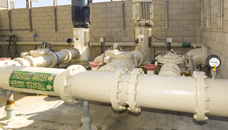 In
the Los Angeles area, desalting plants, such as the Robert W. Goldsworthy desalination
plant in Torrance, Calif., remove salt from slightly salty groundwater. Such
desalination is a good option in Los Angeles, which gets one-third of its water
from groundwater sources and has had saltwater intrusion problems for years.
Photo is by Vince Streano; Courtesy of Water Replenishment
District.
In
the Los Angeles area, desalting plants, such as the Robert W. Goldsworthy desalination
plant in Torrance, Calif., remove salt from slightly salty groundwater. Such
desalination is a good option in Los Angeles, which gets one-third of its water
from groundwater sources and has had saltwater intrusion problems for years.
Photo is by Vince Streano; Courtesy of Water Replenishment
District.
Los Angeles, for example, gets one-third of its water from groundwater sources and the other two-thirds from surface water imported from central and northern California, as well as the Colorado River, Reichard says. In the 1920s, planners recognized that saltwater was beginning to intrude into the coastal aquifers. By the 1950s, they had begun installing a series of injection wells to halt saltwater intrusion. Freshwater injected into these wells raises pressures in the aquifer to create a barrier that stops saltwater from intruding further inland. The wells don’t work perfectly in stopping the saltwater intrusion, Reichard says, “but it would have been a lot worse without them.”
The region also enacted water conservation measures, Reichard says, and has been processing additional water for “reuse”: either treating wastewater and reusing it in a process called reclamation, or desalinating slightly salty, or brackish, groundwater. The region is increasingly using the reclaimed water as a source for the injection barriers.
While these options may work fine for Los Angeles or other areas, Reichard says, they’re clearly not going to work everywhere. Cost is a big factor. Where it will work, reclaiming water can be a cost-effective option, Reichard says. And while desalination of slightly brackish water is becoming more economical every year, he says, it still costs $1.50 per 1,000 gallons, whereas standard surface water treatment costs are only about 25 cents to 45 cents per 1,000 gallons. Desalinating seawater is much more expensive than either option.
Using reclaimed wastewater would not work in Virginia Beach, however, as a good-sized industrial base is needed to provide enough water, and Virginia Beach is 80 percent residential, Mitchell says. And while desalination of brackish groundwater was an option for nearby towns, including Chesapeake, Suffolk and Gloucester, it was not feasible for Virginia Beach, as there isn’t even enough brackish groundwater to desalinate — much less good groundwater — in the city limits to supply enough water to the growing city.
After years of study, the planning commission decided that the most economical and practical option, beyond conservation, Mitchell says, was an interbasin water transfer. The city built a 122-kilometer-long (76 miles) pipeline from Lake Gaston on the North Carolina-Virginia border to a nearby reservoir and then to a plant in Norfolk, which treats the water and sends it into Virginia Beach.
The project came online in January 1998, and can provide up to 60 million gallons of water per day to residents of Virginia Beach and Chesapeake — enough water to supply a growing population through 2030, Mitchell says. “Right now, we’re considering our options for beyond 2030,” when the population may exceed what Lake Gaston can supply.
An interbasin water transfer worked for Virginia Beach in the short-term, but unfortunately for many other areas, building new dams and reservoirs and transferring water isn’t an option. The high economic and social costs of acquiring land and meeting environmental and regulatory requirements may make it a fairly obsolete option, Eggleston says. So they’ll have to turn elsewhere. “Everything will have to become an option,” he says.
“Rather than just engineering solutions, cities are going to have to look at whole basin management — integrated surface water-groundwater management — and will have to take into account all water uses and all water users,” Reichard says. That is sometimes difficult to do, when each municipality or community has its own needs to fill, and when the geology may vary enough that options that work in one place will not work just up the road.
In the case of Virginia Beach and the surrounding Hampton Roads area, whole-basin management is something “we’re all looking at,” Mitchell says. The long-term water future of the area depends on it.
Sever is a staff writer for Geotimes.
Links:
USGS
Virginia Water Science Center
USGS
California Water Science Center
USGS
report on freshwater-saltwater interactions along Atlantic Coast
Water
Replenishment District of Southern California
Virginia
Beach Tourism
"Sizing up a crater,"
Geotimes, January 2006
Back to top
 |
Geotimes Home | AGI Home | Information Services | Geoscience Education | Public Policy | Programs | Publications | Careers |