
Cuyahoga Valley National Park straddles the Cuyahoga River, which flows into Lake Erie. Paddling a kayak along this river today, it is hard to imagine that contaminated water downstream from the park created an event that propelled the United States into one of its largest environmental cleanup efforts.
 On June 22, 1969, just before
noon, an oil slick and debris in the Cuyahoga River caught fire. Firefighters
extinguished the fire in about 30 minutes, but the river — so contaminated
that its surface caught on fire — drew significant public attention and
helped mobilize the nation to pass the Clean Water Act.
On June 22, 1969, just before
noon, an oil slick and debris in the Cuyahoga River caught fire. Firefighters
extinguished the fire in about 30 minutes, but the river — so contaminated
that its surface caught on fire — drew significant public attention and
helped mobilize the nation to pass the Clean Water Act.
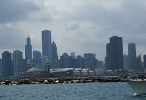
Lake Michigan is a popular recreational area for residents and tourists in Chicago, Ill. Like the other four Great Lakes, the water body is receiving increased attention, as water quality and invasive species threaten the health of the ecosystem and the viability of the drinking water source. Photo is by Sheldon Pinsker.
In 1972, the Canadian and U.S. governments signed the Great Lakes Water Quality Agreement to restore and enhance the quality of water in the Great Lakes. Two years later, the area later known as Cuyahoga Valley National Park became a National Recreational Area.
But toxic chemicals were not the only threat to the Great Lakes during the 1960s and 1970s. Two nonnative aquatic species had entered and settled in the Great Lakes since the Welland Canal was opened in the early 1800s: sea lamprey, a jawless fish with no natural lake enemies, and alewives, a small bait fish native to the Atlantic Ocean. By the 1960s, lamprey predation had killed off lake trout in all of the Great Lakes except Lake Superior, and 90 percent of the fish by weight in Lake Michigan were alewives.
Without lake trout or other predator fish to keep their numbers under control, alewives expanded until their numbers were unsustainable and massive die-offs occurred each year. Millions of alewives washed up on beaches, creating a stinky mess that kept people from using the otherwise beautiful beaches. In response to this situation, the binational Great Lakes Fishery Commission was created to attack the invasive species problem and help restore balance to fish populations in the lakes.
Fast forward more than 30 years to the present: Between water-quality improvements and measures to control invasive species, the lakes have begun to approach a more sustainable balance.
Forty million people in the United States and Canada now rely on the Great Lakes for their drinking water. Sport fishing in the lakes contributes $4 billion to the U.S. economy. Transportation of bulk materials on the lakes is important to industry in ports such as Chicago, Toronto, Cleveland, Duluth and Detroit, and was key to these cities’ location and development. In the summer, beaches along some of the 16,000 kilometers of shoreline are teeming with people.
But while the Great Lakes have come a long way since that wake-up call in the 1960s, not all of the old problems that threatened the lakes have been solved, and new threats have also arisen. Within the last several years, new invasive species have been introduced faster than control measures can be instituted. In addition, new sources of water contamination are taking their toll on the health of the Great Lakes ecosystem.
So, the two nemeses of the Great Lakes — invasive species and water quality — are back, and efforts to prevent a return to the status of the lakes’ ill health in the 1960s have recently brought together scientists, citizens and political leaders from many organizations throughout the region. Together, they are trying to promote the restoration and protection of the Great Lakes, to reinvigorate the work that began in the 1970s, and to address the issues that now threaten these important freshwater resources.
Glacial history
Over the last 1.8 million years, continental glaciers repeatedly advanced into and over the Great Lakes region, leaving behind various glacial deposits. These deposits cover the bedrock to thicknesses of as much as 411 meters (1,350 feet) in north-central Michigan. The Great Lakes themselves formed from continental glaciers that selectively scoured depressions into soft or fractured bedrock during multiple glacial advances — creating basins that filled with water after the ice sheets retreated.
The five resulting lakes constitute the largest concentration of fresh surface water in the Western Hemisphere — about 6 quadrillion gallons. By comparison, Lake Mead, impounded behind Hoover Dam on the Colorado River, contains about 0.15 percent of the total amount of water contained in the Great Lakes.
Of all lake systems in the world, only Lake Baikal in Russia contains more water than the Great Lakes. Even though the surface area of Lake Baikal is only a little larger than Lake Erie (one of the smaller Great Lakes), Baikal contains more water because it is much deeper than any of the five Great Lakes. Spread evenly across the continental United States, the water of the Great Lakes would be about 3 meters (10 feet) deep.
Natural changes in the Great Lakes result from both large and small events and take place over many timescales. For example, since its most recent creation by the advance and retreat of the last continental ice sheet, Lake Michigan has varied from one-third of its current surface area to about 10 percent larger than is today.
As recently as 20,000 years ago, all of the Great Lakes were filled with glacial ice. The weight of the ice caused Earth’s crust to sink. As the glacial ice lobes melted, the crust slowly rebounded and continues to do so today. That rebound is a factor in determining the location of outlets for the lakes and in controlling water levels.
These repeated glacial advances and retreats, as well as crustal rebound, are largely responsible for the current landscape of the Great Lakes region. One result of these processes is that one-third of the drainage area of the Great Lakes basin is covered by water of the Great Lakes themselves, which is a much larger portion than most watersheds.
With such a large amount of water in storage, it takes an average of 100 years to replenish water in the entire system. That means that once an unwanted substance enters the lake system, it takes a long time to be flushed out. Because of this slow 1 percent annual replenishment rate, the Great Lakes are more vulnerable to climate- and human-caused stresses than would otherwise be expected for such a large body of water.
Pinpointing the problems
The coastal areas of the Great Lakes are rapidly developing as more and more people recognize the aesthetic and recreational values of living on the edge of these great inland water bodies. This development has placed additional pressure on the coastal and near-shore areas, which are more sensitive to stress, and has resulted in habitat loss and other changes that have affected the entire ecosystem.
 The impact that the millions
of people who live and work in the Great Lakes watershed have on the surrounding
ecosystems is hard for most people to grasp, as many small unsustainable activities
can mount up to a large impact. Burning oil on the Cuyahoga River is an impact
that is obvious to all, but some of today’s environmental issues for the
Great Lakes are less obvious.
The impact that the millions
of people who live and work in the Great Lakes watershed have on the surrounding
ecosystems is hard for most people to grasp, as many small unsustainable activities
can mount up to a large impact. Burning oil on the Cuyahoga River is an impact
that is obvious to all, but some of today’s environmental issues for the
Great Lakes are less obvious.
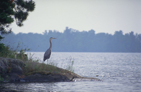
Many plants and animals live in the Great Lakes region, including great blue herons. Pollution, invasive species and other threats are affecting the ecosystem balance. Image is courtesy of U.S. Geological Survey.
For example, identifying a “point source” of pollution, such as an oil slick, and then cleaning it up is easier than locating and rehabilitating a distributed, so-called nonpoint, source of contamination, such as excess lawn fertilizers and pesticides in an urban setting, or fertilizers and herbicides in an agricultural setting. Nonpoint sources have now become the basin’s largest source of contamination, replacing the point sources of years past.
Many toxic chemicals that persist in the environment also originate as nonpoint sources — mercury being a notable example. Long-range atmospheric transport of mercury is responsible for its introduction into the lakes, even though recent reductions in mercury emissions (largely from coal-fired plants) have resulted in a decline of mercury levels in the region. Still, the high levels of mercury in the Great Lakes and other lakes in the region have prompted fish-consumption advisories, as the toxic form of mercury builds in the tissues of fish in higher levels going up the food chain.
Many of the contaminated sediments left over from an era of less stringent regulation of toxic chemical discharge also are located in harbors or a near-shore setting, placing an additional chemical burden on the coastal zone. Additionally, despite a concerted effort to upgrade municipal wastewater discharge, some older municipal sewer systems still discharge untreated sewage into the Great Lakes during periods of high rainfall and runoff. Due to human health concerns from contact with contaminated near-shore water and sediment, beach closures sometimes occur.
Also affecting the lakes’ ecosystem are invasive species, which degrade habitat, kill native and naturalized species, and are hard to control. About 160 nonnative aquatic species are now established in the Great Lakes, and the list is growing. For example, zebra mussels entered the lakes from ships’ ballast water over time, and the mussels are now ubiquitous in the Great Lakes and beyond into the Mississippi River system via the Chicago Ship and Sanitary Canal. A buildup of these mussels around water intakes often causes substantially reduced water flows, necessitating expensive removal of the invaders.
A collaboration
In an effort to rejuvenate ongoing work to restore the Great Lakes, President Bush issued an executive order in May 2004 that recognized the Great Lakes as a “national treasure,” and created a federal Great Lakes Interagency Task Force to improve coordination of federal programs in the Great Lakes watershed. The order also directed the administrator of the U.S. Environmental Protection Agency to convene a “regional collaboration of national significance for the Great Lakes.”
The resulting Great Lakes Regional Collaboration is a wide-ranging, cooperative effort to design and implement a strategy for the restoration, protection and sustainable use of the Great Lakes. While the collaboration is a U.S. effort, synchronization with similar Canadian efforts is considered an essential component of any Great Lakes restoration strategy.
When it began, the collaboration organized experts into eight strategy teams, based on priorities identified by the Council of Great Lakes Governors. The teams consist of approximately 1,500 subject-matter experts with diverse backgrounds from federal, state, regional, municipal and tribal governments, as well as nongovernmental organizations and universities.
The experts presented their results in a report entitled “Strategy to Restore and Protect the Great Lakes” on Dec. 12 at a special ceremony at the Shedd Aquarium in Chicago. The paper outlines specific actions related to water quality and ecosystem function that should take place over the next five to 15 years. The actions fall into two main groups that mirror the dominant problems — ecosystem function (especially invasive species) and water quality.
Strategies for improving ecosystem functions include immediate action to stop the introduction of more aquatic invasive species by preventing introductions through ship ballast water and other means, as well as stopping invasions through canals and waterways. Recently, for example, the Great Lakes collaboration supported construction and operation of two electrical barriers on the Chicago Sanitary and Ship Canal to keep Asian carp, a nonnative species, from getting into the Great Lakes. One of the barriers is currently operational, and the second is in the testing phase.
The report also recommends establishing a program for rapid response to an invasion, and education and outreach to make sure more people know about the danger of this threat to the Great Lakes. In addition, the plan calls for habitat and ecosystem protection.
To address water quality issues, the plan recommends removing contaminated sediment from the most contaminated areas and reducing nonpoint sources of contamination. A new partnership on the Maumee River Basin — which enters Lake Erie at Toledo, Ohio, and extends south to as far as Fort Wayne, Ind. — could provide a good framework for such efforts.
The Maumee project involves an agreement between urban and rural areas in the three affected states — Ohio, Michigan and Indiana. It includes efforts to stop the contamination of streams from agricultural runoff through the use of natural barriers, as well as to educate farmers about better practices that reduce potential contamination. The urban component has yet to start, but the Great Lakes collaboration is hopeful that such a project will serve as a model to other areas.
The strategy also calls for the control of untreated sewage discharge to the lakes, protecting beaches and drinking water sources, as well as improving the infrastructure required for this protection. Because toxic pollutants continue to stress the Great Lakes ecosystem, reducing or eliminating the discharge of mercury, PCBs, dioxins, pesticides and other toxic chemicals is also a major goal.
The work will continue in earnest, as each day, U.S. freshwater becomes more valuable, and the urgency to protect it and the ecosystems it supports becomes more vital. The fire on the Cuyahoga River in 1969 was a catalyst for change in the Great Lakes and started the nation on a quest for sound environmental actions at all levels of society. We have just embarked on a renewed quest to restore the Great Lakes and help to protect and sustain these precious water resources for future generations.
|
Geologic information provides vital support in helping address the many issues facing the Great Lakes region. Especially useful are 3-D geologic maps, which can take a close look at water resources and aid in the development of groundwater models, while helping with the restoration and management of coastal and inland habitat, including wetlands. Over the last 30 years, several new geologic map publications have synthesized new and existing geologic map information in the Great Lakes region. At the broadest scale, 1:1,000,000, the various map sheets in the Quaternary Atlas map series portray surficial materials and stratigraphic units, and revisions of the glacial chronology. New state maps of Illinois, Michigan, Indiana and Ohio have shown continuing revisions at 1:500,000 scale. More recently, the state geological surveys of Illinois, Indiana, Michigan and Ohio, along with the U.S. Geological Survey (USGS), formed the Central Great Lakes Geologic Mapping Coalition to produce detailed 3-D geologic maps of surficial materials in the glaciated areas of these four states. The states have a similar geologic heritage and need to address common societal issues about the environment, geologic hazards, and land and water resources. By pooling their expertise and resources, the five geological surveys are addressing these issues more effectively than any one could alone, as no one survey had the financial, intellectual or physical resources necessary to conduct a massive geological mapping effort at the national standard scale of 1:24,000. As a result, geologists from the coalition members developed a plan that prioritized the study areas and outlined methodology to map the geology of the more than 500 study area quadrangles, to portray it in 3-D and develop associated digital databases. The plan, which includes federal funding, calls for a three-year pilot phase followed by 14 more years of work. These new efforts complement other ongoing cooperative efforts among the state surveys as part of the joint USGS and Association for American State Geologists National Cooperative Geologic Mapping program, as well as with local universities, to produce detailed geologic maps of the glaciated portions of the Great Lakes region. Such efforts will go a long way in helping to provide the basic geologic information necessary to effectively help restore and manage the Great Lakes region.
JMM |
 |
Geotimes Home | AGI Home | Information Services | Geoscience Education | Public Policy | Programs | Publications | Careers |