
Drying springs and sinking land remind residents in the arid southwestern United States about the growing problem below their feet — the dwindling supply of groundwater. Since 1907, when settlers drilled the first flowing well in Las Vegas, scientists have found levels of groundwater declining in the Southwest up to about 90 meters, according to the U.S. Geological Survey (USGS).
 Water shortages affect more
than just the Southwest, however, as aquifers across the United States face
stresses posed by growing populations. “It’s a widespread problem,
not just in the West but across the country,” says Bill Alley, chief of
the USGS Office of Ground Water. Shortages also pose concern worldwide, as discussed
in March at the 4th World Water Forum held in Mexico City.
Water shortages affect more
than just the Southwest, however, as aquifers across the United States face
stresses posed by growing populations. “It’s a widespread problem,
not just in the West but across the country,” says Bill Alley, chief of
the USGS Office of Ground Water. Shortages also pose concern worldwide, as discussed
in March at the 4th World Water Forum held in Mexico City.
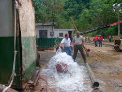
In 2001, Robert Bisson of ETI and Lennox Persad of Lennox Offshore Services, Ltd., watched the final pumping test on a well that taps into a deepwater aquifer below Trinidad. The well provides residents of the island with about 1.3 million gallons per day of water. Photo is by Robert Bisson/ETI.
Concern about a dry future has put hydrogeologists and engineers on the case to find a solution. Some hydrologists are pushing for changes to how states manage and distribute water from known aquifers. Others, however, think that huge reserves of water exist, yet undiscovered, deep below the surface. To locate those reserves, scientists are putting new twists on old exploration tools, to try and gain an edge in an increasingly competitive groundwater market.
Most groundwater exploration techniques used by consultants today have been on the market for years, says William Turner, a hydrogeologist and president of American Ground Water Consultants (AGW) in Albuquerque, N.M. For example, hydrogeologists have long used tools that measure electrical resistivity, in which a current applied to Earth’s surface can determine properties associated with the soil and rock belowground that correspond to where groundwater most likely exists, whether it’s trapped by impermeable layers of rock, or held within porous material. So far, Turner says, most of the techniques “rely upon some geophysical or physical property of the rock.”
AGW scientists focus instead on identifying physical characteristics associated with the groundwater, using a proprietary thermal method called “Thermonics.” When heat from Earth’s interior passes through moving groundwater, water absorbs some of the heat and disperses the rest in various directions. Using equipment sensitive enough to distinguish temperature to 0.005 of a degree Celsius, AGW scientists can measure temperatures near the surface to help them map subsurface groundwater.
Thermonics helped AGW hydrologists locate well sites for a land development in Vail, Ariz., 32 kilometers east of Tucson, after other efforts had failed, according to an AGW case study. The company report noted that previously, the best well in the entire Tucson basin produced 600 gallons of water per minute. Using Thermonics, AGW scientists discovered a narrow, 30-meter-wide aquifer. The first well drilled produced 600 gallons per minute and out of the following seven wells, the best produced 1,000 gallons per minute — enough to supply about 5,500 residences with water, Turner says. The developer no longer needed to haul in water from elsewhere.
Despite success for AGW, other companies have not picked up the Thermonics technique because background temperature differences, such as shade from a tree, can interfere with measurements, Turner says. But “we know how to correct the data,” he says, which AGW has used to locate well sites mostly for industrial uses, including slaughter houses and oil and gas refineries, as well as to trace water moving below and through dams in Pakistan and Kentucky. But AGW has never published details about the method because, Turner says, “that would give away our competitive edge.”
Other scientists are trying to find new groundwater sources by measuring differences in Earth’s surface temperatures from as far away as space. Farouk El-Baz, director of the Center for Remote Sensing at Boston University, and colleagues have analyzed satellite images to locate groundwater sources in the arid regions of Oman and the United Arab Emirates.
Thermal devices aboard a satellite have the capability of mapping temperature differences down to half a degree Celsius. Researchers next use image-processing methods that compile the data into maps that show detailed thermal anomalies over vast tracts of land. “We’ve done that very well in Oman, and we’re now applying it all over the place,” El-Baz says.
El-Baz and colleagues now use the thermal maps to discover the path that rainwater, after accumulating from rainfall in mountain ranges, follows downhill into lowlands. For example, the team traced water collected in the Rocky Mountains, all the way to basins in New Mexico, about 150 kilometers away. The method works, El-Baz says, because when the cold mountain groundwater flows into the warmer lowlands, the temperature contrast shows up in the satellite images as an anomalous dark spot.
The technique, however, is not restricted to mountainous regions; El-Baz and colleagues also look for temperature anomalies along the world’s coastlines. Ground-water emanating from fractures along coastal zones is a huge source of potential freshwater that goes wasted as it seeps into the sea, El-Baz says.
To locate these sources, the researchers take advantage of the tendency for fresh groundwater to be either colder or warmer than the seawater. In the case off the coast of Oman, the warmer plume shows up on satellite thermal maps as a well-defined line. Similar contrasts exist in tropical regions, except that the emerging fresh groundwater is colder than surrounding seawater.
Currently, El-Baz is working with a Fulbright scholar to map groundwater seeping off the coast of Lebanon into the Mediterranean, so that in the future, engineers can drill and capture it before it escapes into the sea. “When this is successful,” El-Baz says, “we’re going to apply it all over the place.”
The problem remains, however, that although researchers have already analyzed entire coastal regions of Earth, they have not yet studied the maps for the specific purpose of looking for coastal freshwater seeps. “We want people to start to look,” El-Baz says. “This is a very good potential for more water worldwide.”
In the southern United States, for example, a seemingly large amount of freshwater seeps into the Gulf of Mexico from the Florida coast, El-Baz says. Tampa, in particular, has almost a continual flow, he says, although the exact amount has not been measured. “It’s a source of water that has not been used.”
That source could be critical for cities such as Tampa that face water supply problems because the population there is growing “like crazy,” says Dave Wiley, a hydrologist with the consulting firm Legette, Brashears & Graham, Inc. He says that historically, Florida’s prolific aquifer allowed engineers to put a well in the ground and “boom, you get water.” But the growing population is increasing the competition for the resource, he says, and the state is turning tax dollars toward research on techniques such as desalination (desalting) and forcing water back into the ground.
 Despite the worldwide abundance
of research, however, the overall advancement in groundwater exploration has
been slower than exploration for other resources, according to Jay Lehr, a hydrogeologist
and consultant for EarthWater Technology International, Inc. (ETI). Since the
early 1980s, he says, most resources, including oil, are cheaper today (accounting
for inflation), due to significant advancements in exploration, development
and refining techniques. “It boggles my mind,” Lehr says, that similar
advancements have not been made as quickly for water.
Despite the worldwide abundance
of research, however, the overall advancement in groundwater exploration has
been slower than exploration for other resources, according to Jay Lehr, a hydrogeologist
and consultant for EarthWater Technology International, Inc. (ETI). Since the
early 1980s, he says, most resources, including oil, are cheaper today (accounting
for inflation), due to significant advancements in exploration, development
and refining techniques. “It boggles my mind,” Lehr says, that similar
advancements have not been made as quickly for water.
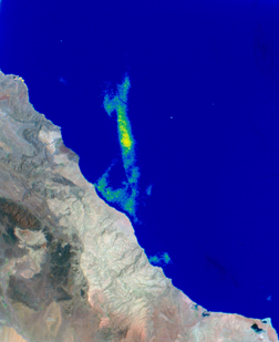
Groundwater that seeps from the eastern coast of Oman is warmer that the seawater it enters, producing thermal anomalies visible from satellites in space. Some scientists think that if tapped, the seeps could supply a large amount of freshwater, which currently goes to waste. Image is courtesy of Center for Remote Sensing, Boston University.
To advance groundwater exploration, Lehr thinks that it’s not so much a matter of advancing a technology, as it is using technology to compile a “colossal” amount of data. Compiled into complex models, the data could reshape what scientists know about groundwater systems.
Lehr has worked for about 20 years with hydrogeologist Robert Bisson, also with ETI, to understand the complex dynamics of aquifers on a large scale, an approach they coined the “megawatershed” model. Generally, Lehr says, people have thought that very deep aquifers, up to about 900 meters below the surface, are stagnant and nonrenewable, like an oil well, but “we find that not to be true at all.” Instead, deep aquifers are part of a hydraulic continuum and can be resupplied by rain and surface water through fractures in the bedrock, Lehr says. Drilling at these sites produces wells that turn out water volumes “a hundred times greater than what anyone imagined.”
The idea behind Lehr’s and Bisson’s megawatershed approach to locating groundwater is to incorporate huge datasets over large areas. They combine a region’s attributes, such as tectonic history, precipitation, vegetation, infrastructure, soils and structural geology, into digital maps over large areas. Such maps then reveal locations that are most likely to have the characteristics of an aquifer.
Their method proved a success in the Caribbean, Lehr says, when in 1999 an involved analysis of Tobago led an ETI exploration team to drill into volcanic bedrock — a move that delivered 4 million gallons of water per day to residents, and has since sustained residents and tourists through successive droughts. In 2000, the team compiled new and old data and used GIS to locate a 15-million-gallon-per-day well on the island of Trinidad, and identified untapped sources there containing a potential of 200 million gallons per day.
The next step, Lehr says, is to apply the system to the southwestern United States. According to numbers compiled in 2000 by the U.S. Census Bureau, northern Las Vegas is the second fastest growing region in the United States, adding stress to the area’s dwindling water supply. “We think our system is the best thing that could happen to Las Vegas,” he says. So far, a few years of work there has not turned up any new groundwater sources, Lehr says, “but we’re still hopeful.”
 |
Geotimes Home | AGI Home | Information Services | Geoscience Education | Public Policy | Programs | Publications | Careers |