
“At first sight is represented a doleful Tragedy of the demolished City of Beneventum…it being leveled, except the Tower of the Cathedral, so that the finest Epitaph might be there written, Here was Beneventum, there not being one stone left upon another,” wrote an anonymous eyewitness to an earthquake that hit Italy on June 5, 1688.
 Now known as the Sannio earthquake,
it had a magnitude of 7.1 with an epicenter in the southern Apennine Mountains
about 48 kilometers (30 miles) northeast of Naples and 19 kilometers northwest
of Benevento (also known as Beneventum). In addition to the eyewitness’
description of church bells ringing by themselves, numerous aftershocks and
people wailing in the streets, the quake produced surface ruptures, rock falls
and landslides across 50,000 square kilometers. As many as 10,000 people died.
Now known as the Sannio earthquake,
it had a magnitude of 7.1 with an epicenter in the southern Apennine Mountains
about 48 kilometers (30 miles) northeast of Naples and 19 kilometers northwest
of Benevento (also known as Beneventum). In addition to the eyewitness’
description of church bells ringing by themselves, numerous aftershocks and
people wailing in the streets, the quake produced surface ruptures, rock falls
and landslides across 50,000 square kilometers. As many as 10,000 people died.
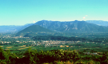
The Calore River valley, in the southern Apennine Mountains in Italy, is home to a newly identified and analyzed fault zone thought to be responsible for a devastating earthquake in 1688. Photo is by Daniela Di Bucci.
The Sannio quake is but one of numerous sizable tremors felt and recorded in Italy over the past 2,000 years. Despite the long historical record, few details are known about some of the quakes because they took place on unknown fault systems, where no good field evidence exists. A recent study, however, is using previously unexplored geologic structures to unravel the complex fault systems that underlie the area, and could help local planners better prepare for future seismic events.
Geologists working in the Apennines face several challenges in trying to understand the region’s recent seismic history. Most of the underlying structures formed from the convergence between the African and Eurasian plates that has dominated regional tectonics since the Late Cretaceous. But then, about 800,000 years ago, movement of the plates across the southern Apennines became the primary tectonic force. These complex and conflicting stresses make deciphering modern faults comparable to untying a Gordian Knot.
New work published in the March 2006 Bulletin of the Geological Society of America, however, brings together a diverse line of geologic and historic evidence to tease out what caused that “horror of an unheard of Catastrophe” of 1688. The work by Daniela Di Bucci of the National Seismic Survey of Italy and her co-authors centers on “relay ramps,” the first time a group has used such structures to understand and define a fault source.
Relay ramps are zones that appear as a slope, or ramp, that bridges two overlapping normal faults as a means to accommodate the plates’ movement. The Sannio relay ramp has started to break down and now appears as small faults, fractures and tilted blocks. Other areas of active plate movement with well-known relay ramps include the East African Rift, Canyonlands National Park in Utah, and the Gulf of Suez.
In unraveling the story of the 1688 Sannio quake, Di Bucci’s team dated terraces along the Calore River and examined centimeter- to meter-sized faults at 36 sites, to define the timing along the fault system responsible for the quake. They also compared the Sannio system with the Boiano Basin fault system (about 25 kilometers north), which last moved in 1805, and found that a relay ramp connects these two fault systems.
The new analysis reveals how earthquakes move on the Sannio, or Calore River fault system, as Di Bucci’s team dubs this newly understood structure. Their work rules out the possibility of an earthquake “jumping” between the Boiano and Calore systems via the relay ramp. Thus, any earthquake along the Calore will have a magnitude directly related to the length of the Calore faults, rather than gaining energy from a combination of fault systems.
“This is a great study because they have tackled a subtle signature,” says Jon Lewis, a structural geologist at Indiana University of Pennsylvania. “It’s impressive the way they pulled together the geologic and historic information to understand the geometry of these structures and the associated seismic hazards.”
Di Bucci says that she hopes the information will help to update the current national hazard maps of Italy, which do not take into account fault data. Research groups are now developing a national database to create better seismic hazard maps, she says. “Our hope is to see our results ultimately integrated in these studies and thus finally contribute to the mitigation of the Italian seismic risk.”
David Williams
Geotimes contributing writer
Back to top
For tens of millions of years, erosion processes from streams and wind worked to erase all visible evidence of the Sahara’s largest crater — but they didn’t succeed.
 Researchers noticed the circular
rim of the crater on Feb. 20 while looking at satellite images of Egypt’s
Western Desert. Farouk El-Baz and Eman Ghoneim, scientists at Boston University’s
Center for Remote Sensing in Massachusetts, who made the discovery, suggest
that the feature’s large diameter helped keep the crater hidden. Whereas
the crater would have been difficult to discern from land-based observations,
data from space gives an overall view of Earth’s surface that “no
other data can offer,” Ghoneim says.
Researchers noticed the circular
rim of the crater on Feb. 20 while looking at satellite images of Egypt’s
Western Desert. Farouk El-Baz and Eman Ghoneim, scientists at Boston University’s
Center for Remote Sensing in Massachusetts, who made the discovery, suggest
that the feature’s large diameter helped keep the crater hidden. Whereas
the crater would have been difficult to discern from land-based observations,
data from space gives an overall view of Earth’s surface that “no
other data can offer,” Ghoneim says.
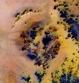
Images from space revealed the largest known crater visible in the Sahara. The structure spans 31 kilometers large enough to contain about 70,000 football fields. Photo is courtesy of Boston University Center for Remote Sensing.
Measuring in at 31 kilometers across, the crater (nicknamed “Kebira,” which is Arabic for “large”) dwarfs the Sahara’s previous largest known crater, the 12.6-kilometer-wide Aorounga crater in northern Chad. Other telltale features include an outer rim, inside of which exists a second ring of material. Double-ring features are characteristic of larger craters on Earth, although the phenomenon is more clearly noticeable in the well-preserved craters on the moon.
The team speculates that Kebira formed when an enormous meteor hit Earth, leaving a lasting impression in the 100-million-year-old sandstone. The impact could provide an explanation for the origin of mysterious yellow-green glass found in the region, Ghoneim says, which could have been created by heat from an impact melting and fusing together pieces of sand.
Kathryn Hansen |
Geotimes Home | AGI Home | Information Services | Geoscience Education | Public Policy | Programs | Publications | Careers |