On Jan. 18, 2000, a meteorite blazed through the night sky and landed
on the frozen surface of Tagish Lake near the Yukon-British Columbia border
in Canada. One week later, several fragments were removed from the icy
lake. Analyses have revealed the meteorite, now called the Tagish Lake
meteorite, is a new type of carbonaceous chondrite that also appears to
be the least altered meteorite ever found on Earth.
Its the best snapshot we have of the bulk chemical composition of
the early solar nebula, Peter Brown of the University of Western Ontario
says. Because the meteorite has experienced little thermal or aqueous alteration,
its composition is the best analogue scientists have to study how particles
in the solar system originally condensed.
Some of the meteorites components even pre-date the solar system.
The Tagish Lake meteorite contains some of the most pristine pre-solar
grains known to exist on Earth. Also known as interstellar grains, these
crystals are small, refractory grains generated when a supernova explodes
or in the cooling atmosphere of a giant star. They are the only tangible
source of information we have on Earth for learning about the nucleation
of stars.
Brown and his colleagues published their findings in the Oct. 13 Science.
We are in the delightful position of knowing that most of the interesting
things we can learn from Tagish Lake [meteorite] have yet to come, Brown
says.
Laura Wright
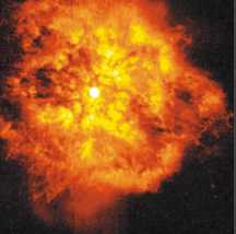
The interstellar grains found
on the Tagish
Lake meteorite might provide
insight into the
evolution of stars such as
the young and
violently erupting, super-hot
star shown in this
image taken by Hubbles Wide
Field Planetary
Camera 2 in March 1997.
Photo courtesy of NASA.
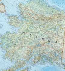 Seismic profiling
has revealed approximately 30 blind, transpressional faults running through
Cook Inlet in south-central Alaska, in addition to the exposed Castle Mountain
fault that has been known to be active since the 1960s. Peter Haeussler
of the U.S. Geological Survey in Anchorage believes these faults were formed
only in the past 1.5 million years and are active today. Over the past
15 to 20 million years, the Yakutat tectonic block has been pushing against
the coast of Alaska, essentially squirting part of the fore arc to the
southwest, Haeussler says.
Seismic profiling
has revealed approximately 30 blind, transpressional faults running through
Cook Inlet in south-central Alaska, in addition to the exposed Castle Mountain
fault that has been known to be active since the 1960s. Peter Haeussler
of the U.S. Geological Survey in Anchorage believes these faults were formed
only in the past 1.5 million years and are active today. Over the past
15 to 20 million years, the Yakutat tectonic block has been pushing against
the coast of Alaska, essentially squirting part of the fore arc to the
southwest, Haeussler says.
