geotimesheader
Feature
| Mapping
the Outcrop
By J. Douglas
Walker
and Ross A.
Black
|
Teaching
field geology with laptop computers and geographic information systems
brings digital mapping to the outcrop.
|
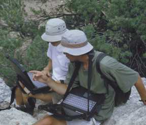
Above: Students
scope the area and enter data into their laptops. Photo by Anthony Walton. |
Over the last 20 years, geologists have evolved from die-hard computer-phobes
to people using computers in virtually every aspect of their work. Now
computers are making inroads into that last bastion of the old-school
geologist: basic field mapping on the outcrop.
A field mapper can still pull on a pair of boots and grab a backpack,
hammer and base map and conduct field work without a computer. Even with
the advent of the personal computer, most outcrop mappers remain independent,
self-reliant and proud of the low level of technology necessary to make
original geological contributions to the scientific community.
But computers have become ubiquitous within our society. This is especially
true in higher education. Todays student has been exposed to computers
since an early age, and many students now actually see computers as a primary
learning tool. Who better, then, to test digital mapping technologies than
students? Over the last two years, we have been teaching our geology students
to use laptop computers and geographic information system (GIS) software
in the field.
Mapping itself is becoming a digital process (Geotimes, June
2000). With the advent of the Internet, we expect new scientific information
to be digital. Large corporations, government agencies and, to some extent,
universities began major efforts to put new information into a digital
form many years ago. They also had to come to grips with the fact that
it is tedious and expensive to convert older data into a usable digital
form.
Entering historic data into a system where it can be integrated with
other information is a chore. Entering mapping data into the computer is
one of the geologists more onerous tasks. The endearing term digi-slave
is common in laboratories and offices converting maps into digital data
sets. Making mapping information digital from the earliest point of the
mapping process in the field could save the mapper many time-consuming
steps.
Geological data are location dependent: the elevation and location at
which an observation is made is just as important as the observation itself.
This is why most geological data are recorded in a map-based format. Geological
outcrop observations are thus well suited to being recorded and manipulated
with existing GIS software packages.
We and our students use GIS software to compile, compose and view geologic
maps. We also use such software to merge maps with satellite imagery, aerial
photography and other data sets, and for visualizing data in 3-D for modeling
geological processes.
Our GIS lab has been integrating large geological and geophysical databases
for the last six years. We have put a tremendous amount of time and effort
into converting paper-based geological data into a digital form.
Existing geological maps are by far the hardest sources of information
to enter into a database. The information on the map consists of on-the-fly
interpretations of observations the field geologist made on the outcrop.
The person digitizing the map must also interpret the map symbols on-the-fly.
Why not enter the data into the GIS package on the outcrop, eliminating
the need for another step in the lab that is technical, time consuming,
costly and prone to error?
After asking ourselves this same question, we started putting together
a computer-based field-mapping program. Several private companies, government
agencies and academic groups were pursuing the same goal, and we
met them at meetings of the Geological Society of America, American Association
of Petroleum Geologists, American Geophysical Union and the Environmental
Research Institute Users Group. Some groups, most notably the Canadian
Geological Survey, Bowling Green State University and the University of
California at Berkeley, had digital mapping programs in place. But almost
everyone was at about the same stage we were.
We investigated the technologies we could pursue and then sought funding
for the project. We received funding from the University of Kansas (KU)
Technology Fund, the Geothermal Program Office of the U.S. Navy and the
KU Department of Geology.
| Students
in the field
We first used the computers and software in a graduate level mapping
course offered in January 1999. Four graduate students signed up. These
students had previous mapping experience, and three of the four had used
ArcView software.
The students first had to figure out how to carry their laptops into
the field. They dug into a box of straps, buckles, clips and tape we had
purchased from a camping store, and, after an hour of fiddling, were ready
to go into the field. Most of the first day was spent getting used to the
computers and trying to enter geologic data on the outcrop.
In a word, the students were very unhappy with the whole operation at
the end of the day (mutiny might be a more accurate term). Carrying the
nine-pound computers was not fun, digitizing was a pain, the screens were
hard to read and the batteries were weak and heavy. We were not very encouraged. |
Students using
computers during a University of Kansas field
camp. Photo by
Anthony Walton. |
To avoid a total loss of field time, the students printed maps and took
them into the field to map on the next day. This went fine until it came
time to enter the data into the computer. Predictably, this was a tedious
operation. Sensing that the computers could actually save some time and
effort, we went out with computers and paper maps the third day. By the
end of the day the students were mapping pretty well on the computers and
were in better spirits.
We spent another seven days in the field mapping and working out problems
with the computers and software. By the end of two weeks, three of the
four students were happy with the mapping setup. The fourth remained unconvinced
that we had come up with anything useful.
After this session, it was with great uneasiness that we introduced
computer mapping into our undergraduate field camp in June of 1999. We
taught eight undergraduate students in the last week of a six-week field
course. None of them had ever used a GIS program, let alone ArcView. We
gave them the same short, three-hour introductory session wed given the
graduate students and then sent them into the field.
The undergraduate experience could not have been more different from
the graduate one. The students were very excited about mapping with computers
and welcomed the change from paper maps, photos and mylar overlays. Most
students were comfortable with the computers by the end of the first day;
by mid-morning of the second day they were asking questions about the geology
and not about how to use the programs.
We attribute these different reactions to two factors. First, the undergraduates
are not set in their ways about mapping. They did not have the background
baggage the graduate students carried. Second, the undergraduates were
more used to computers. The age difference of a couple of years is just
enough that the younger students expect to use computers in all aspects
of their education and most aspects of their lives.
The
future
We will continue using computers in University of Kansas field courses.
We plan to expand the undergraduate component to about half of the six-week
course. We still consider conventional mapping skills important. Introducing
the computer adds a level of excitement for the students.
Many of our students are now taking GIS courses. This change is a grassroots
effort among the undergraduates and not an idea the faculty pushed onto
them. They will know more about the basic software components than will
some of the field-camp faculty members.
Some of the problems with field computers are being remedied. Laptops
are getting lighter four pounds instead of nine pounds. Battery life
is steadily increasing. We can map all day on a single lithium-ion battery.
Touchscreens are now readable in sunlight. Personal digital assistants
should soon be powerful enough to run the software and handle the large
image files needed to perform efficient mapping.
The widespread availability of inexpensive (or free) 7.5-minute topographic
maps in various digital formats has been one of the important factors in
making digital mapping systems easier to use. Now we need inexpensive,
large scale, aerial photos at digital resolutions useable for geological
field studies.
The final component for digital mapping is GPS receivers. Using the
Global Positioning System (GPS) promises to give the field geologist real-time,
accurate location information. Although we have a method for connecting
the GPS unit directly to the laptop and downloading the location, the GIS
packages do not automatically update the map with the proper map symbols.
Thus it is easier to read the location from the GPS unit and then manually
move the laptop cursor to that point on the map and record the field observation.
We hope that GPS receivers soon become standard options for ruggedized
laptops and that GIS packages include easy-to-use interfaces with standard
GPS data. The demise of selective availability in GPS signals (Geotimes,
June 2000) has made GPS coordinates almost 10 times more accurate.
Improved, publicly available GPS signals my be what pushes GPS/GIS-driven
geological field mapping onto every students field belt in a one-piece
unit that will fit in a Gfeller field case.
Tools
for Digital
Field
Mapping
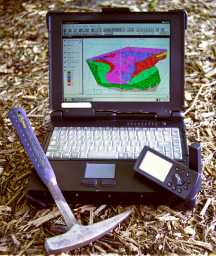
Rocky II field
computer with Garmin GPS unit.
Hammer for scale.
This computer weighs about
9 pounds and is
equipped with two batteries.
Photo by Douglas
Walker.
|
Hardware
Several companies manufacture field-hardened, ruggedized laptops, mainly
for the military and forestry markets. Requirements include: a keyboard
sealed against the elements; a screen that is readable in direct sunlight;
and a metal body.
The most rugged of the machines we use survived the full force of a
graduate student falling directly on the laptop. The handles and the screen
hinges are usually the points that fail under strain. Internal drive bays
are convenient for saving and moving data, but add cost and weight to the
system.
Battery life is usually overrated. By trial and error, we learned to
use all of a computers power saving features that are normally ignored.
The suspend command under Windows was the most valuable.
A stable, readable touchscreen is useful but often expensive.
Other necessary hardware is a Zip drive for nightly backups and a printer
for producing maps.
|
Useful Global Positioning System (GPS) receivers are the small hand-held
units and the larger dome-mounted, real-time differential units. The hand-held
units are light and accurate enough for geological mapping, especially
since the U.S. government removed selective availability from the GPS signals
earlier this year (Geotimes, June 2000). Without selective availability,
most hand-held GPS units have position errors of approximately 10 to 15
meters a sharp pencil line on a 7.5-minute quadrangle map equates to
about 7 meters. Most likely, expensive real-time differential units are
now unnecessary.
Software
Each computer operating system dictates the available software. Although
our GIS lab is mainly Unix-based, we use Windows-based computers in the
field. In the lab we use the entire suite of ESRI, ERDAS and Adobe products
for GIS, remote sensing and finished graphics applications. In the field
we use ESRIs Arcview. Other useful packages are MapInfo, PenMap and various
programming languages, such as Visual Basic and Avenues.
The main flaw in Arcview is that it does not automatically merge boundary
line segments (arcs) into polygons. Students map only the contacts or boundaries
of geological features, and then later must merge them into rock unit polygons.
The Edit Tools software merges the segments, thus expanding the feature
editing we can do.
The GeoClassifier, written by University of Kansas students, adds standard
geological attributes to point, line and polygon data with a set of drop-down
menu buttons large enough to read in the field. We use this extension in
our laboratory for assigning attributes to digitized maps.
The GeoEditor, also a student creation, is similar, but incorporates
support for GPS units that can generate an output stream of NMEA-104 ASCII
text over a serial cable.
When the mapper chooses a point, a Visual Basic routine reads the data
stream from the GPS unit, parses out the coordinates and passes it to the
Arcview extension, which creates a location point in the database.
Download the Edit Tools extension to Arcview from www.ian-ko.com.
Download GeoEditor and GeoClassifer from geomaps.geo.ukans.edu.
Additional Reading
________________________________________________
Bedrock geologic mapping using ArcInfo by T.E. Wahl, J.D. Miller and
E.J. Bauer. Proceedings of ESRI Users Conference, 1995. p. 167.
The Bedrock of Geologic Mapping by P. Chirico. Geo Info Systems,
1997. v. 7, n. 10, p. 26-31.
Development of Geographic Information Systems Oriented Databases for
Integrated Geological and Geophysical Applications by J.D. Walker, R.A.
Black, J.K. Linn, A.J. Thomas, R. Wiseman and M.G. DAttilio. GSA Today,
1996. v. 6, n. 3, p. 1-7.
Getting to Know ArcView GIS by ESRI Press. 1998.
Walker and Black teach in the Department
of Geology at the University of Kansas in Lawrence, Kan.
