Geotimes

Geophenomena
Draining
Mount Pinatubo Corals
on high Typhoons
in Taiwan
Draining
Mount Pinatubo
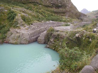
In 1991, Mount Pinatubo erupted, blowing its top and leaving a crater with an
area of 2.1 square miles. Shortly after, drop by drop, the crater began to fill
with rainwater. Pinatubo's crater lake, now between 110 and 120 meters deep,
stands as an engineering challenge atop the Philippine mountain.
 Since early this
year, geologists, engineers and residents of the nearby towns have been working
together to drain the lake. Scientists fear that if the water breaches the crater
walls, it could erode tons of volcanic ash and boulders deposited on the volcano's
slope, and threaten the towns below with torrents of water and debris.
Since early this
year, geologists, engineers and residents of the nearby towns have been working
together to drain the lake. Scientists fear that if the water breaches the crater
walls, it could erode tons of volcanic ash and boulders deposited on the volcano's
slope, and threaten the towns below with torrents of water and debris.
"The idea was to remove loose material to get the lake draining out stably
over hard lava. Ideally, this should have been done a while ago, but it wasn't,"
says Chris Newhall, a scientist with the U.S. Geological Survey. Newhall has
been a technical expert aiding the Philippine Institute of Volcanology and Seismology
(PHIVOLCS) in the first effort to drain a volcanic lake through a canal atop
a crater. He says 10 to 20 meters of loose material sit atop the volcano's lava.
[View of the Pinatubo crater
Lake in the direction of the outflow. The trench, or emergency spillway, has
just reached lake level, with water flowing out gently. The crater lake is located
atop the 1600-meter-high Mount Pinatubo. Image courtesy of Chris Newhall.]
Initially, he says, it was not clear whether the water accumulation was a problem,
because scientists suspected the lake would armor, "washing away the small
stuff, but leaving around the big stuff." Then in January of this year,
an "alarm bell sounded," Newhall says, when some of his students visited
Pinatubo and poured water over the crater's sandy matrix. They quickly saw the
material would erode easily. Still, Newhall adds, the stability of the lake
was in debate right up until June.
In mid- to late August, efforts to drain the lake went into high gear. Armed
with picks and shovels, workers began digging a trench into the loose upper
material of the crater. Hand digging was necessary because of the steep terrain.
After digging down 2.5 meters, scientists and engineers realized that at the
rate they were digging "it would've been Christmas before finishing,"
Newhall says. They decided to limit the trench's width to only a meter for the
remainder of the digging. On Sept. 6, they reached lake level, with a 5-meter-deep
trench, wide at the top and narrow at the bottom. "Because of the low gradient,
water began to pour out gently, meaning there was no major flood," Newhall
says.
The draining efforts have been hailed a short-term success, but Newhall says
that the "jury is still out" on the long-term success. As the rains
continue, water level will rise, and the erosion may lead to a safe armoring,
or it may turn into a runaway flow of water, mud and debris, he says. In mid-September,
the outflow was 0.5 cubic meters a second, the flow of a nice little stream.
PHIVOLCS scientists planned to keep a 24-hour watch at the crater rim through
the rainy season to see how the erosion develops.
Lisa M. Pinsker
Corals
on high
For years, scientists have known that Earth's coral reefs face many local and
global environmental stresses, including climate change, pollution, disease
and over-fishing. Until now, the only way to monitor the effects of these stresses
has been with divers who analyze corals in the field, one site at a time. This
method is both time-consuming and costly. Now, researchers say they have found
a way to monitor coral deaths from 250 meters up with new digital sensors.
Reporting in the Sept. 6 Nature, Peter Mumby and colleagues offer new remote
sensing technology to monitor large areas of coral cover. In the first targeted
study of its kind, Mumby's team used the Compact Airborne Spectrographic Imager
(CASI) system mounted aboard the Golden Eye plane to survey coral in two reefs
in the lagoon of Rangiroa Atoll in French Polynesia. "The main advantage
of the system is that we can cover very large areas that we couldn't previously
study with field surveys," says Mumby, a marine scientist at the University
of Newcastle upon Tyne.
CASI consists of lenses that divide the reef into grids of pixels to record
the amount of reflected light in a spectral band specific to corals. CASI has
been widely used in terrestrial systems and for mapping water quality in rivers,
but Mumby's team is the first to specify CASI for coral monitoring. Mumby says
that in the past, divers measured the colors of corals directly to determine
which were dead or alive. CASI can record coral colors in a spectral band more
focused than the broad bands of many satellite technologies. "Land-based
satellite technologies like LANDSAT can't distinguish subtleties of colors between
living and dead coral," Mumby says.
 Aboard Golden
Eye, CASI surveyed French Polynesia from 250 meters high. Mumby's team obtained
high resolution, 1 meter by 1 meter, multispectral images to compare to on-site
surveys of the coral populations in each reef. The first reef predominately
harbored large live and dead colonies of Porites coral distinguishable at wavelengths
between 506 and 564 nanometers. The habitat in the second reef was more diverse,
including Pocillopora coral, coralline red algae and sand.
Aboard Golden
Eye, CASI surveyed French Polynesia from 250 meters high. Mumby's team obtained
high resolution, 1 meter by 1 meter, multispectral images to compare to on-site
surveys of the coral populations in each reef. The first reef predominately
harbored large live and dead colonies of Porites coral distinguishable at wavelengths
between 506 and 564 nanometers. The habitat in the second reef was more diverse,
including Pocillopora coral, coralline red algae and sand.
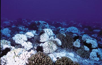
[Bleached coral at Rangiroa atoll,
French Polynesia. Image appears courtesy of J. Jaubert.]
Overall, the CASI images revealed a cover of live and dead coral that differed
from field surveys by no more than 3 percent. In one hour, they acquired images
of more than 92,500 square meters of reef, or 3,700 plots of 25 square meters.
Divers would have needed three days to survey 10 similar plots.
Mumby says that CASI technology can offer scientists a larger, less expensive
and less labor-intensive view of the world's coral reefs. "Ultimately,
what we need is a sensor like CASI mounted on a satellite, or even the International
Space Station, where we could monitor corals regularly, maybe every six months."
Mumby says this method will free divers' time for other important jobs, such
as surveying reef fish and coral diseases.
Lisa M. Pinsker
Typhoons
in Taiwan
Typhoon season hit Taiwan hard this year. On Sept.
26, Lekima, the eighth typhoon Taiwan has experienced this year, struck the
island's southeastern coast, flooding streets and triggering deadly landslides.
A week earlier, Typhoon Nari dropped a record-breaking 32 inches of rain on
Taiwan's capital city, Taipei. Thousands of people evacuated flooded apartments
as wind blew down power lines and landslides inundated nearby villages. Ninety-three
people were killed and extensive agricultural damages resulted in an estimated
loss of $84 million. In July, typhoons Toraji and Utor swept across Taiwan,
also with tragic consequences.
Typhoons (also know as hurricanes, severe cyclonic storms or severe tropical
cyclones, depending on their locality begin as low-pressure thunderstorms that
circle over tropical or subtropical oceans. The storms increase in severity,
becoming strong tropical cyclones when winds reach 117 mph.
Jann Vendetti
