Geotimes
News Notes
Seismology
Turkish tectonics

Researchers recently published preliminary results of the first data collected with modern techniques documenting the tectonic and seismic regimes of eastern Turkey. Their work may overturn conceptions of the tectonic setting of the region.
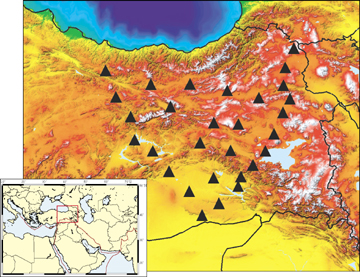
In a series of what will be eight papers in all, seismologists, led by Eric Sandvol from the University of Missouri-Columbia, are laying out the mantle tomography (the velocity that seismic waves travel through different parts of the Earth), crustal structure and other characteristics of the Anatolian plateau in the eastern part of Turkey. The region has been out of reach for geologists over the past decade and a half, owing to civil unrest between the native Kurdish people and the Turkish government.

A 29-station broadband array collected seismic reflection and refraction data in eastern Turkey over almost two years, the first extensive survey of its kind in the region. On this topographic pseudo-color scale map, white represents the maximum elevation. Image courtesy of Eric Sandvol.

“People were concerned for their safety in that region,” Sandvol says. Over the 15-year period of war, lack of fieldwork and the impossibility of deploying modern equipment meant, he says, that “in terms of the subsurface structure, we really knew almost nothing.”

Sandvol and his coworkers from Cornell University in Ithaca, N.Y., and Bogazici University in Istanbul, Turkey, installed a network of 29 broadband stations for their Eastern Turkey Seismic Experiment. The Incorporated Research Institutions for Seismology, a university research consortium, loaned the equipment from its PASSCAL portable seismometers program for almost two years of data collection, recording arriving seismic waves.

The team’s initial interpretations from the seismic array data provide the beginnings of a reassessment of older regional models, plus confirmation of some ideas. The analyses show that there is no crustal and mantle thickening from the collision of Arabia with Eurasia, as projected by some earlier models. “What we found was a slightly thickened crust and no lithospheric mantle,” Sandvol says, in addition to very slow seismic wave speeds in the mantle.

Velocity of seismic waves serves as a proxy for determining the temperature, density and other characteristics of the material through which the waves traveled. The low speeds indicate high temperatures, even hotter than the mantle underlying the spreading African continental rift zone. “The big question,” Sandvol says, is “why is that there?”

So far, the researchers’ results seem to rule out the subduction of the Arabian plate underneath the Eurasian plate. Sandvol says, “what Arabia does is just stop,” abruptly ending underneath the overriding Eurasian plate, instead of extending at a gentle slope beneath it for hundreds of miles. That hypothesis correlates with the lack of earthquakes deeper than 20 kilometers, which are common to deep subducting slabs of crust, as well as to the surprisingly high mantle temperature. Sandvol speculates that such underthrusting processes might occur later in a collision, as they do in the nearby Tibetan Plateau, which would indicate that the Turkey collisions are very young.

The first two papers in the eastern Turkey seismic series were published online Sept. 10 in Geophysical Review Letters, covering tomography and seismic anisotropy — waves traveling in different directions due to variations in the mantle — under the plateau. The next papers will cover crustal structures, seismicity, magma generation, and attenuation of seismic waves in the mantle beneath eastern Turkey. All eight papers are expected to be published in a collected volume this December.

The papers are “preliminary results,” says Nafi Toksöz, a seismologist at the Massachusetts Institute of Technology in Cambridge, who is familiar with the work. Though some of the results are not surprising, Toksöz says, “some of the anisotropy results are new and … quite interesting, but I’m not sure how they will fit with other phenomena in the region.” The two published papers also report potentially conflicting anisotropies for shear and compressional waves, which, he says, will require a mechanism to explain the differences.

Though Toksöz says he would have welcomed more details on the researchers’ methods of analysis, the project was “one of the most successful PASSCAL experiments ever carried out.” The data entered the public domain on Aug. 31, and Toksöz says he expects new results that either support or challenge these preliminary ones from other seismologists soon.

Naomi Lubick

Geotimes Home | AGI Home | Information Services | Geoscience Education | Public Policy | Programs | Publications | Careers

© 2024 American Geological Institute. All rights reserved. Any copying, redistribution or retransmission of any of the contents of this service without the express written consent of the American Geological Institute is expressly prohibited. For all electronic copyright requests, visit: http://www.copyright.com/ccc/do/showConfigurator?WT.mc_id=PubLink