
 Tons
of interplanetary material hit Earth every day. Most of that material is dust,
but Earth and its moon show a record of collisions with much larger objects,
with surprising regularity and incredible destructive force. As evidenced most
famously by the Yucatan crater that marks a collision with an almost 10-kilometer-wide
object, blamed for bringing about the demise of the dinosaurs, life on this
planet could be very much at risk should another large space traveler hit it
today.
Tons
of interplanetary material hit Earth every day. Most of that material is dust,
but Earth and its moon show a record of collisions with much larger objects,
with surprising regularity and incredible destructive force. As evidenced most
famously by the Yucatan crater that marks a collision with an almost 10-kilometer-wide
object, blamed for bringing about the demise of the dinosaurs, life on this
planet could be very much at risk should another large space traveler hit it
today.
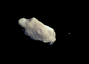
This near-Earth asteroid measures about 58 kilometers long and 23 kilometers
wide — large enough to be of some concern if it were ever to collide with
Earth, an unlikely event. The now-defunct Galileo mission took images of the
asteroid Ida on its way to Jupiter in 1993. Image courtesy NASA.
Though the likelihood of such an impact now is relatively small, this past summer,
a team from NASA and an independent group of concerned astronomers separately
released documents that called for more science on so-called near-Earth objects
(NEOs). Although all the researchers admit that panic isn’t necessary,
they say some planning ahead is; the two documents, one a NASA report and the
other an open letter to Congress and the public, particularly highlight concerns
over smaller bodies that could hit the planet and have not yet been found.
Using visible impact craters on other bodies in the solar system as a proxy,
as well as other criteria, NASA researchers estimate that NEOs larger than 1
kilometer in Earth’s vicinity number about 1,100. So far, a project nicknamed
Spaceguard has found about 60 percent of those. The remaining 40 percent should
be found within the decade (the goal is to find 90 percent by the year 2008).
“The question has always been protecting ourselves against large impacts,”
says David Morrison of NASA’s Ames Research Center in Mountain View, Calif.
“The Spaceguard survey is designed to deal with those large asteroids and
has done so very successfully.” The two new reports raise the question
of whether observers should look for the smaller ones, he says.
Smaller objects have the potential to do a lot of damage on their own, by landfall
or creating tsunamis in the ocean. Anything bigger than 15 meters is large enough
to get through Earth’s atmosphere. But it’s the objects that are about
50 to 100 meters across — estimated to number in the hundreds of thousands
— to really worry about, says Don Yeomans, manager of the NASA Near-Earth
Object program office in Pasadena, Calif. The higher numbers lead to higher
likelihoods of an impact: The larger asteroids may hit only every half million
years or so, but relatively smaller ones could ping Earth as often as once every
millennium.
Asteroid observers know how easy it would be to nudge an object off its destructive
course. “Decades of warning [give us] time to experiment with a variety
of ways of changing the orbit,” Morrison says. A slight bump with a remotely
operated spacecraft or, as suggested by some, a well-placed nuclear explosion
on an object’s surface would change the trajectory of an object hurtling
toward Earth by several centimeters a second.
Either technique, Yeomans says, “would ablate the [outside], and the outgassing
would introduce a rocket-like thrust.” If a known object were calculated
to hit in two decades, then just “a few millimeters per second in velocity
change over 20 years would be more than enough,” he says, to move an object
off its course.
If scientists catalog an Earth-collision-bound object even a decade before its
predicted impact, they still have an adequate window of time to respond, Morrison
says. Planning to move a smaller NEO would be easier than a 1-kilometer or larger
object. Or, he says, “we could decide to just take it,” and allow
an impact to occur.
NASA submitted its report on Aug. 22. The team determined that it would take
20 years at most (starting in 2008) to catalog the smaller NEOs, in order to
determine which have trajectories that might pose a threat. Such work would
also take several hundred million dollars, a cost of risk reduction that the
team balances against the costs of an impact.
Concerned astronomers, both amateur and professional (and unaffiliated with
NASA), wrote their open letter to Congress earlier this summer, on July 8, suggesting
the same kind of efforts. Though not a crisis, they say, they want action. The
letter, signed by Carolyn Shoemaker (at Lowell Observatory in Flagstaff, Ariz.),
Neil de Grasse Tyson (director of the Hayden Planetarium in New York City) and
Freeman Dyson (at the Institute for Advanced Study in Princeton, N.J.), among
others, called for more funding to find NEOs of all sizes. It also laid out
recommendations for robot exploration missions and a federal response plan,
should an impact occur.
But the issue, says Yeomans, who was on the NASA team, is exactly who should
respond. The astronomers’ open letter asks Congress to set aside money
for relief agencies and other federal and community support groups, in the event
of an impact. Yeomans says such contingency planning and disaster relief is
a good idea, but he suggests establishing a chain of responsibility instead,
in the unlikely scenario that a large undetected impactor is about to hit. “Right
now, if we find something on an Earth trajectory,” he says, “I’m
not sure who we would call.”
Naomi Lubick
Links:
A
list of near misses from the Jet Propulsion Laboratory
Near-Earth
Object program at Jet Propulsion Laboratory;
An open
letter to Congress
Back to top
 U.S.
Geological Survey (USGS) researchers using LIDAR — light detection and
ranging aerial mapping — found a new fault near Seattle. The find may change
scientific assumptions about the shape and location of the tectonically active
Seattle fault system. Geologists have been using LIDAR to locate new faults
in the region since 1998 and have located surface ruptures in at least five
different fault zones.
U.S.
Geological Survey (USGS) researchers using LIDAR — light detection and
ranging aerial mapping — found a new fault near Seattle. The find may change
scientific assumptions about the shape and location of the tectonically active
Seattle fault system. Geologists have been using LIDAR to locate new faults
in the region since 1998 and have located surface ruptures in at least five
different fault zones.
Because faults in the Pacific Northwest are often obscured by the
region’s dense foliage, geologists are finding previously unmapped scarps
with LIDAR images. Flying over the region, imagers fire rapid laser beams towards
the ground. The beams bounce back upward to sensitive detectors in the plane,
and the resulting data are then analyzed with a computer program that disregards
trees and other aboveground cover to create a topographic map.
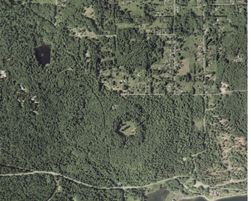
Using LIDAR images, geologists found
a new fault on southeast Bainbridge Island, Washington (pictured at left), which
is perennially covered with dense foliage.
USGS geologists studying LIDAR images noticed a scarp on the south end of Bainbridge
Island, a 28-square-mile island northwest of Seattle. Brian Sherrod of USGS
soon obtained permission from the landowners and began excavating a 15-meter
long and 3- to 4-meter deep trench on the forested hillside. In the trench,
Sherrod identified and recorded the soils and important stratigraphic contacts.
He then identified the fault — an easy task, he says. The fault had pushed
13-million-year-old Miocene bedrock over 16,000-year-old glacial rock deposits
and less than 2,000-year-old Holocene soils. The fault runs right up to the
ground surface.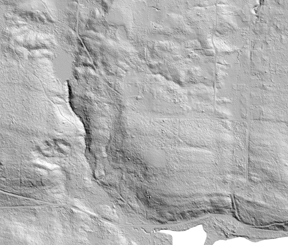
Sherrod has sent the soil and rock deposits off to a lab for exact dating, which
should indicate more precisely how long ago this large surface deformation occurred.
If the fault proves to be the same age as the rest of the surface faults in
the large Seattle fault zone, then no new hazard will be assessed. The active
fault system underlies Seattle and the densely populated Puget lowland, and
its precise location, geometry, displacement history, and slip rates are poorly
defined. Every new discovery helps map the faults, which helps to assess the
hazard.
LIDAR images (right) remove the foliage
and other ground cover to reveal hidden geologic features, such as the Toe Jam
fault. Images courtesy of USGS and the Puget Sound LIDAR Consortium.
Sherrod says that though they have known there were faults that they hadn’t
yet mapped, “the importance of this find is that it will drive the science
in a new direction. We will have to develop a new model for the Seattle fault
zone.”
The new fault dips north and is located farther north than previous models projected
the Seattle fault zone. Old models had the zone reaching only as far north as
downtown Seattle, with a large south-dipping floor thrust fault forming a base
surface, as well as a series of roof thrusts above. Because both the location
and geometry are conflicting, scientists will likely have to create a new fault
geometry model, Sherrod says. At least one more fault even farther north than
this one, he says, will force even further modeling.
Using these findings, USGS geologist Tom Broker developed a new model that has
the floor thrust dipping south but a whole series of north-dipping shallow roof
thrusts. He says researchers need to sum up the motion on these faults, shallow
and deep alike, to interpret and accurately model the previous and potential
deformation from the Seattle fault system.
As a member of the Puget Sound LIDAR Consortium, USGS receives LIDAR imaging
deliveries once or twice a year from the contractor who performs the imaging.
The consortium is a group of local agency staff and federal research scientists
devoted to developing public-domain high-resolution LIDAR topography and derivative
products for the Puget Sound region.
“Every time we get a new delivery of data we find new stuff to work on,”
Sherrod says. “We pour over it for a couple of weeks and identify what
we can. We have a backlog of sites to work on now.” Before the use of LIDAR,
geologists knew of one place in the Puget lowland that had ruptured the surface
during a past earthquake. Since they began using the technology, they have identified
surface ruptures in at several different fault zones. Sherrod adds that they
have dozens of potential targets to study in the field in the near future. “Not
all of those will end up being fault scarps, but a lot of them will,” he
says.
The geologists mapping the region use the standard 7.5-minute topographic quadrangle
maps and aerial photographs in addition to the LIDAR, but as Sherrod says, “out
here, you’re really just looking at the tops of trees.” They use LIDAR
to develop contour maps more detailed than standard topographic maps. Sherrod
says, “when we can, we use LIDAR.”
Megan Sever
Links:
Puget
Sound LIDAR Consortium
Back to top
 |
Geotimes Home | AGI Home | Information Services | Geoscience Education | Public Policy | Programs | Publications | Careers |