Geotimes

Untitled Document

Web Extra
Monday, November 29, 2004
Earthquake strikes Indonesia
again
 A
magnitude-7.2 earthquake struck Papua, Indonesia, on Friday morning at 11:25
a.m. local time, according to reports by the U.S. Geological Survey (USGS).
Following this large temblor were multiple aftershocks, one of which registered
magnitude-6.1 on Sunday at 4:36 p.m. The main pulse and the aftershocks resulted
in 19 deaths, more than 180 people reported injured and at least 300 buildings
destroyed.
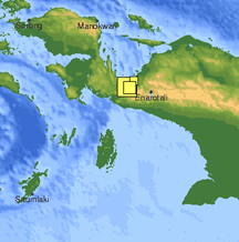
Multiple earthquakes
have struck Papua, Indonesia, in the past month. The overlapping yellow squares
indicate the areas affected by the the most recent temblor and its aftershocks.
Larger squares indicate higher magnitude quakes. Image courtesy of USGS.
Police Commissioner Wempi Batlayeri told the Agence France-Presse that
continuing tremors and aftershocks are preventing Papua residents from going
home, and they are setting up makeshift camps to protect themselves from the
rain. Patients at a state-run hospital are also being treated outside, as officials
are fearful of a collapse due to structural damage to the hospital. The Indonesian
Red Cross is helping survivors and displaced residents by providing medicine,
tents and mosquito nets.
Sandwiched between four tectonic plates, Indonesia is one of the most tectonically
active regions in the world, according to USGS. Two weeks prior to this large
quake, on Nov. 12, a magnitude-7.5 earthquake struck the eastern Indonesian
island of Kepulauan Alor (see Geotimes coverage).
Compiled by Laura Stafford
Links:
USGS
National Earthquake Information Center
"Powerful
earthquake strikes Indonesia," Geotimes Web Extra, Nov. 12, 2004
ABC
Radio Australia online coverage
Jakarta
Post Online coverage
Back to top
Untitled Document

 A
magnitude-7.2 earthquake struck Papua, Indonesia, on Friday morning at 11:25
a.m. local time, according to reports by the U.S. Geological Survey (USGS).
Following this large temblor were multiple aftershocks, one of which registered
magnitude-6.1 on Sunday at 4:36 p.m. The main pulse and the aftershocks resulted
in 19 deaths, more than 180 people reported injured and at least 300 buildings
destroyed.
