 A magnitude-6.9 earthquake
rumbled through Bolivia and northern Chile yesterday. No immediate deaths or
damage were reported, according to Reuters, although people
evacuated their homes. Still, people felt the earthquake over hundreds of kilometers,
as the waves of the 162.5-kilometer-deep earthquake dissipated while traveling
through the planet's crust.
A magnitude-6.9 earthquake
rumbled through Bolivia and northern Chile yesterday. No immediate deaths or
damage were reported, according to Reuters, although people
evacuated their homes. Still, people felt the earthquake over hundreds of kilometers,
as the waves of the 162.5-kilometer-deep earthquake dissipated while traveling
through the planet's crust.
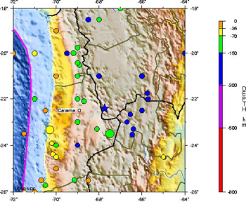
This map of the Potosi region of Bolivia shows all magnitude-7 and greater earthquakes
since 1900, including a magnitude-6.9 temblor that struck yesterday (marked
by a blue star), at a depth of about 160 kilometers. Image courtesy of the U.S.
Geological Survey.
The earthquake was centered 110 kilometers (70 miles) east of Calama, Chile,
in the Potosi region of Bolivia. The region's residents are used to feeling
earthquakes: Western South America straddles the subduction zone where the Pacific
plate dives beneath the South American continent. The immense Andes mountain
chain is a product of this meeting of the plates; the Pacific plate plunges
down hundreds of kilometers beneath the mountains, deforming as it travels deeper
into Earth's mantle. That deformation produces large earthquakes at extreme
depths within the plate itself, some as deep as 500 kilometers or more.
But the biggest earthquakes in the region occur when an earthquake originates
from interactions between the two plates, as happened in 1960, when a magnitude-9.5
Chilean earthquake — the largest earthquake ever recorded — set off
a massive tsunami and killed thousands of people.
Naomi Lubick
Links:
USGS
preliminary report for Nov. 17 Bolivian earthquake
USGS
historical seismicity for region and 1960
Chilean earthquake
Reuters
news alert, Nov. 17, 2005.
 |
Geotimes Home | AGI Home | Information Services | Geoscience Education | Public Policy | Programs | Publications | Careers |