
 Weather forecasters
once relied on human observations, recorded in long-maintained historical sources,
to painstakingly calculate incoming weather patterns. They used a mix of statistics
and gut-level instincts colored by experience. Today’s weather prediction
models — calculated by computers using algorithms — rely on data collected
by an army of satellites and ground-based measuring devices. These machine observers
provide a wealth of information around the globe, but even they remain spotty
in their coverage.
Weather forecasters
once relied on human observations, recorded in long-maintained historical sources,
to painstakingly calculate incoming weather patterns. They used a mix of statistics
and gut-level instincts colored by experience. Today’s weather prediction
models — calculated by computers using algorithms — rely on data collected
by an army of satellites and ground-based measuring devices. These machine observers
provide a wealth of information around the globe, but even they remain spotty
in their coverage.
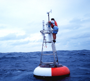
A buoy in NOAA’s equatorial Atlas
TOGA-TAO array, used to track El Niño or La Niña events by measuring
depth profiles of ocean temperature, underwent maintenance in 1999. The Global
Earth Observing System of Systems will facilitate data sharing among those scientists
who use buoy data, among other information. Image courtesy of Lieutenant Mark
Boland, NOAA Corps.
An international effort is under way to fill in the gaps in weather and climate
data through the Global Earth Observing System of Systems (GEOSS). But its mission
is broader than just weather: The undertaking will provide links to data around
the world, from ocean hydrophones to the dozens of satellites circling the planet.
Following on the coattails of the World Meteorological Organization (WMO), which
spearheaded modern international data-sharing efforts in the 1950s, almost 60
countries and over 40 international organizations have agreed to set up a huge
infrastructure within less than a decade. The idea is for data to flow freely
across national borders, just like the weather.
Some observers say that such an endeavor will have amazing benefits if it can
get off the ground. The consortium’s participants have only recently hammered
out their priorities for research in a wide array of earth science fields, and
their goals eventually should be used to guide participating countries’
future investments in science, infrastructure such as satellites, and other
elements that GEOSS members will eventually identify. Intended for use in hazards
reduction and sustainable development, GEOSS could potentially benefit the meteorological
community as well.
Data sharing
More than 150 years ago, WMO started to forge data-sharing agreements to patch
together the bits and pieces of information collected by many nations. Temperature
records, for example, kept by local governments, as well as those reported on
ships crossing oceans, became elements of the catalog. The complexities of data
sharing meant determining protocols not only on how to collect it, but also
how to format it (for example, ship captains followed rigorous rules in their
notations), not to mention how to deliver it. Today, “metadata” describe
just exactly what the numbers represent and how they are stored, the data’s
original source, and sometimes how to correct them — preferably in electronic
databases accessible via the Internet.
In the beginning, “weather data were not really worth anything,” says
Paul N. Edwards, a historian at the School of Information at the University
of Michigan in Ann Arbor. “The transmission was not fast enough” —
sometimes taking months to mail from stations around the planet, and even longer
to finally publish — “and the quality was very poor,” he says.
In addition to those conditions, the state of forecasting made the data economically
and politically unimportant, so countries didn’t bother to control the
information flow.
Nevertheless, the growing meteorological community established a philosophy
of worldwide cooperation, Edwards says. Through WMO, an autonomous body that
cooperates with the United Nations, countries can get certain datasets from
each other easily, due to shared protocols and simplified politics as a result
of longstanding agreements. And now the data have proven to be very important,
economically and politically, as science and technology have improved forecasting
abilities.
“You’ve got a very blurred distinction now between weather and climate”
forecasting, says Elbert Friday, former head of the U.S. National Weather Service
and now at the Sasaki Applied Meteorology Research Institute at the University
of Oklahoma. “Long-range weather forecasting” used to mean two weeks,
or a month. “Some people now call that a ‘short-range climate forecast,’”
he says, something that took off starting with the demand for more accurate
weather forecasts in the Vietnam War. At the time, when Friday was serving as
the last U.S. weatherman stationed in Vietnam, the best estimates of weather
were “very crude,” he says. Today, people expect National Weather
Service models to kick out forecasts reliable to the hour.
The success in climate and weather models started in the 1980s with advances
in computing power. Forecasters now rely on more densely packed datasets, and
they need data on many parameters both to describe the starting point of a system
(initial conditions) and to update a model as it runs (data assimilation). Of
course, the more accurate the data, the more accurate the predictions, says
Marshall Shepherd of NASA’s Goddard Space Flight Center in Greenbelt, Md.,
who is the deputy project scientist for the Global Precipitation Measurement
mission, expected to launch by 2011 — a part of the GEOSS era.
More real-time data worldwide would “improve our ability to resolve these
processes at the timescales at which they occur,” Shepherd says, whether
using the soon-to-be-completed Indian Ocean tsunami buoy system to track a large
wave moving across the ocean, or ocean surface temperatures to forecast the
development of a hurricane. As seen with recent disasters, such as Hurricane
Katrina or last December’s Indian Ocean tsunami, “more data, at the
right time and space scales, could be very valuable for assessment, prediction,
or recovery,” he says.
Gap filling
 GEOSS eventually
should serve as a conduit for getting more data from around the world to fit
into weather and climate modeling efforts. As new satellites or ground-based
observations are made in a variety of fields, they will be put online or otherwise
made available to a variety of users. Researchers see several areas where such
an infrastructure could fill in gaps.
GEOSS eventually
should serve as a conduit for getting more data from around the world to fit
into weather and climate modeling efforts. As new satellites or ground-based
observations are made in a variety of fields, they will be put online or otherwise
made available to a variety of users. Researchers see several areas where such
an infrastructure could fill in gaps.
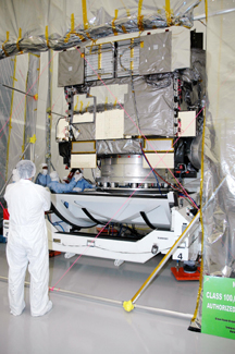
Boeing employees check a geostationary
satellite, the GOES-N, before its launch earlier this year. The satellite, along
with its predecessors, is sponsored by NASA and the National Oceanic and Atmospheric
Administration, and makes measurements for use in weather, solar and space science.
Image courtesy of NASA Kennedy Space Center.
For hurricanes, “one of our main ways of improving the prediction of the
path and intensity of the hurricane is not only monitoring the hurricane itself
but also its environment,” Shepherd says. One of the primary reasons Hurricane
Katrina became so large so fast was because the Gulf of Mexico waters were a
couple of degrees warmer than average. Forecasters were still able to accurately
anticipate where the hurricane would travel and its ultimate size. Still, they
need data “to resolve small gradients or changes in sea-surface temperature,
wind shear, convection, and other variables that influence the intensity of
such storms,” Shepherd says.
Meteorologists say that sea-surface temperatures and wind profiles are the major
pieces of data they are missing. Ronald McPherson, emeritus executive director
of the American Meteorological Society, says his “personal top priority”
over the past two decades has been arguing for the development of atmospheric
wind profiles over the world’s oceans.
A network of weather balloons, launched twice daily to track temperature, humidity,
pressure and wind on their flights up through the atmosphere, has existed since
the 1930s, and has been a “backbone of weather and climate systems, as
far as those variables are concerned,” McPherson says. But the stations
have mostly been over land, with spotty coverage over the world’s oceans
coming from planes and a few satellites tracking cloud movements. Such measurements
are “hideously expensive” with current technologies (one weather balloon
costs several hundred dollars, for example), and McPherson says that he is hoping
that GEOSS will help fill that gap by directing funding from several partner
countries to maintain such everyday programs.
In addition to winds, Friday has a wish list that includes details of atmospheric,
ocean surface, land surface, and ice and snow conditions. Variations in land
surface conditions, for example — whether an area is vegetated, has been
recently harvested or has changing soil moisture content — feed back into
weather forecasts. “Because all of these [conditions] interplay, weather
forecasting is not a simple process,” Friday says. “You can forecast
for your own area, maybe by knowing what’s going on in the nearest 100
to 200 to 300 miles. But when you want to know what’s going to happen in
the next week, … and in the next season, then you need a global understanding
of what’s going on.”
For now, earth-observing efforts consist of individual governments’ activities,
sometimes conducted in concert, but in the end, for their own needs. Europe,
for example, receives less severe weather than the United States, Friday says,
and so European meteorological bureaus focus more on supporting aviation and
agriculture. But the data they collect could be more universally useful, GEOSS
supporters argue, shared among the meteorological and other science communities
for other countries’ purposes.
Problem solving
GEOSS is only in its initial stages, with a 10-year plan under way for completion
by 2013. (One of its many committees just embarked on a two-year project to
settle on data-sharing protocols.) Initiated by the international community
in various meetings under the auspices of the United Nations and Group of 8,
and carried most recently by the enthusiasm of Vice Admiral Conrad Lautenbacher,
head of the National Oceanic and Atmospheric Administration, and others for
the past five years, the consortium has been housed and sponsored primarily
by the United States. Early this year, GEOSS headquarters moved to WMO’s
offices in Geneva, Switzerland, but the organization remains outside the United
Nations — a potential drawback, according to some observers.
“The challenge will be to ensure the commitment to GEOSS from all the agencies
and countries involved, when the organization responsible for implementing it
is outside the United Nations system,” says John Zillman, former president
of WMO and former director of the Australian Bureau of Meteorology. Its success
ultimately will depend on building “a strong sense of ownership within
WMO and the other earth-observing U.N. agencies,” says Zillman, who is
now president of the Australian Academy of Technological Sciences and Engineering.
He says that others think it will succeed better initially outside the U.N.
framework.
Whether or not GEOSS remains independent, the issues it represents have now
been moved “up to the ministerial level, instead of [to] directors of weather
services, which is primarily the membership of WMO,” Friday says. That
means “that there are national commitments being made” for support
and money for Earth observations.
Aside from the politics involved, the new secretariat in charge of GEOSS must
oversee a potentially bewildering assortment of efforts. The system requires
agreements on formats and protocols for data exchanges, as well as standards
for observations — the same as what the meteorology community has agreed
to over the past century, but now for the seismology, oceanography, ecology,
chemistry, sociology and other communities (see sidebar, opposite page).
The newly chosen GEOSS secretariat must encourage or support countries in their
work to launch satellites and maintain ground-based observation systems. In
this voluntary alliance, potential problems could occur, for example, with funding
issues, such as in the United States, where long-term stream gage data —
tracking a key part of the hydrologic cycle and therefore important to weather
observations — are perpetually in danger of running dry with the potential
loss of funding from Congress and state and local partners. Even within the
meteorological community, trends in collecting atmospheric weather balloon data,
for example, have not been promising. Over the past several decades, the number
of balloons launched has been about halved, according to Friday, particularly
in several South American and African countries, which cannot afford to maintain
their systems.
The international community also adopted another mission for GEOSS: to pull
less-developed countries along with those already in the throes of major observation
programs. Such efforts are noble, but also could be partially thwarted. Several
countries have already made it clear that they consider both the data and potential
products stemming from it to be economically valuable or state secrets. Iraq
notably has sequestered its hydrologic and dam data for its rivers for decades.
More recently, India’s government banned any monsoon forecasts that might
compete with the official one from the India Meteorological Department, telling
Nature on July 14 that it was too economically important to be undermined.
Such a dictum may be difficult to enforce if nations or foreign companies choose
to make their own forecasts.
Meanwhile, the United States and Europe, particularly Britain, have had what
McPherson calls “a shaky détente” in the debate over the value
of weather and climate observations, and whether governments that make them
“should recover all or a portion of the cost.” Unlike in some European
countries, in the United States, law requires that information obtained with
taxpayer funding be made available “at no more than the cost of making
it available,” he says, which created a “bitter divide” between
Europe and the United States, “especially in the weather communities.”
“Satellites have made it possible for one country to collect data from
the whole world,” Edwards says. “To the extent that this works, you
don’t need data from other countries, so you might start to think about
selling [data] or restricting access.” Although this creates the possibility
that countries might become “highly proprietary” toward their meteorological
data, Edwards does not think this shift will be a big problem. “A great
beauty of the meteorological system is its long tradition that most data should
be freely exchanged.”
National pride or protectionism still could lead some countries to remain outside
the GEOSS data-sharing process, but a simpler problem that may leave nations
out of the loop is a lack of Internet access, McPherson says, particularly in
some African countries and elsewhere where the communications infrastructure
is minimal. Although that issue remains a challenge for some of its 187 members,
WMO, nevertheless, has managed so far to keep them in the loop, providing and
sharing other countries’ data with success.
GEOSS may not have a large impact on weather forecasting “simply because
the WMO already has that game sewn up,” says Geoff Love, director of the
Australian Bureau of Meteorology. But Love says that GEOSS will make a difference:
“Put very basically, there are generally few or no international standards
for the collection and free exchange of data in areas beyond meteorology,”
he says, “and given the way observing, data-exchange and data-management
technologies are evolving, it is high time this was done.”
|
Weather,
water, disease and more |
 |
Geotimes Home | AGI Home | Information Services | Geoscience Education | Public Policy | Programs | Publications | Careers |