
 On Aug.
13, two people died when a tornado careened through the coal-mining town of
Wright, Wyo., injuring at least a dozen people and destroying about 50 mobile
homes. Residents had only five minutes to prepare.
On Aug.
13, two people died when a tornado careened through the coal-mining town of
Wright, Wyo., injuring at least a dozen people and destroying about 50 mobile
homes. Residents had only five minutes to prepare.
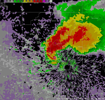
Doppler radar captured this large tornado
as it hit the General Motors plant in Oklahoma City, Okla., May 8, 2003. Meteorological
software was used to provide a warning 30 minutes in advance — long enough
to safely move 1,200 employees to a shelter. Image courtesy of NOAA.
In 2004, 1,819 tornadoes were recorded in the United States, according to the
National Oceanic and Atmospheric Administration (NOAA) Storm Prediction Center,
and from this total, 20 were classified as “killer tornadoes” and
responsible for 36 deaths. Most occurred during tornado season, which is April
to June, and in a region called Tornado Alley — an area spanning from the
Dakotas to the Gulf Coast, bordered on the west by the Rocky Mountains and on
the east by the Appalachians. But tornadoes can form at any time or location
if conditions are right; Hurricane Katrina was responsible for 36 confirmed
twisters. The challenge in forecasting tornados is that scientists have yet
to fully understand their physics and the conditions that spawn them.
“In terms of using computer models to predict tornadoes, like we currently
use computer models to predict weather seven to 10 days in advance, we’re
not there yet, and probably won’t be there for a long, long time,”
says Kelvin Droegemeier, a professor of meteorology at the University of Oklahoma
in Norman, and director of the Center for Analysis and Prediction of Storms
(CAPS).
Droegemeier and colleagues, however, in addition to researchers at NOAA, have
made progress in recent years. Advancements in radar technology have increased
the quality of data, which in turn are used in increasingly sophisticated models.
The models serve as the basis of the NOAA Storm Prediction Center’s tornado
outlooks, watches and warnings, and the center has been working in conjunction
with the media and the National Weather Service to increase the number of people
who receive the messages with the maximum time to prepare.
The first step for researchers is to learn more about the components of tornado
formation. “Part of the thing about predicting the weather is understanding
how it works, understanding the dynamics,” Droegemeier says. A simple explanation
for conditions in Tornado Alley is that dry air from the Rocky Mountains meets
warm and moist air from the Gulf and cold air from the north. The interaction
of hot, cold and dry create ideal conditions for the formation of supercells
— rotating thunderstorms necessary for tornado generation. The problem
is that tornado formation is complex, and conditions favorable for supercells
do not guarantee a tornado.
One way that researchers are trying to learn more about tornado dynamics is
through close observations of the twisters themselves, especially from Doppler
radar. NOAA operates the Next Generation Weather Radar, or NEXRAD, which since
1988 has employed Doppler technology in a network used to identify and warn
about dangerous weather and its location. Now 158 radar stations dot the United
States, leaving few holes in the coverage. “It definitely assists us in
issuing watches,” says Dan McCarthy, a warning coordination meteorologist
at the NOAA Storm Predictions Center.
At large distances, the curvature of Earth prevents NEXRAD from scanning close
to the ground. At about 400 kilometers away, the gap can be as large as 5 vertical
kilometers — a gap in which there is “a lot of the stuff that is a
precursor to tornadoes,” Droegemeier says, and NEXRAD “is missing
it.” Thus, 3 out of every 4 tornado warnings are a false alarm, he says.
To “fill in the holes,” Droegemeier is working with researchers at
the University of Massachusetts in Amherst, Colorado State University in Boulder,
the University of Puerto Rico in Mayaguez, and corporate and government partners
on a project called the Center for Collaborative Adaptive Sensing of the Atmosphere
(CASA). The notion is to deploy small, inexpensive and low-power Doppler radar
units on cell-phone towers, starting with a small Oklahoma test installation
in spring 2006. Unlike NEXRAD, they would not scan at long-range distances,
but instead would collect data close to the ground. Droegemeier says he hopes
that the system will observe precursor structures in storms, before a tornado
actually forms. Such data could prove useful to NOAA in issuing warnings prior
to tornado development, which is something, McCarthy says, is “the biggest
challenge we have.”
Improved radar technology has created an increase in the volume of tornado data,
a development that Harold Brooks, a research meteorologist at the NOAA National
Severe Storms Laboratory, says is one of the greatest recent advances in tornado
forecasting. He says that researchers previously studied conditions surrounding
about 20 cases in which tornadoes occurred. Now researchers have datasets for
hundreds of storms, including conditions that did not spawn tornadoes. Brooks
says that the information will help meteorologists working to distinguish the
parameters that make a storm turn into a tornado or not.
The large amount of data has in turn been useful to researchers such as Ming
Xue, a meteorology professor at the University of Oklahoma, who has been using
technology at the Pittsburgh Supercomputing Center to create what the center
calls “the most realistic tornado simulation ever done.” The project
reproduced the vortex structure and wind speeds of a tornado spawned by a severe
storm in 1977.
Computing power limited previous simulations to linear areas on the scale of
about 100 meters, too small to reliably capture forming tornadoes and maintain
high resolution. Now, Xue has increased the computable area to capture 50 kilometers
on each side of the storm.
To simulate a one-hour storm, the program calculates temperature, pressure and
air speed every second for 24 hours and produces 20 terabytes of data. Xue says
that he hopes that his research will provide better understanding of tornado
dynamics, in addition to developing algorithms to be used in tornado-detecting
radar programs such as CASA’s.
Droegemeier thinks that in general, research is leading toward the ability to
predict the occurrence of severe storms up to a day in advance. But along with
increased prediction capabilities are the issues of how to prepare people in
the path of a potential storm. “You can’t look at the science problem
just as a science problem,” Droegemeier says. “You actually have an
important social dimension.”
McCarthy estimates that about 70 percent of people get weather information from
TV, posing a problem when warning for the “tornadoes that work on Sunday
nights, when the media goes home.” Longer forecast times may someday alleviate
that problem, but for now, NOAA is working to increase the accuracy of watches
and warnings. This fall, the agency plans to change the warning zones from generic
boxes to more exact county-by-county warnings. “The accuracy is getting
good enough now that we can start to get more precise and refine our thinking
a little bit, so that we don’t over warn,” Droegemeier says, and do
not increase public apathy.
Kathryn Hansen
Links:
Center
for Analysis and Prediction of Storms
NOAA's
National Weather Service Storm Prediction Center
Center
for Collaborative Adaptive Sensing of the Atmosphere
Back to top
 |
Geotimes Home | AGI Home | Information Services | Geoscience Education | Public Policy | Programs | Publications | Careers |