by Thomas Staudacher
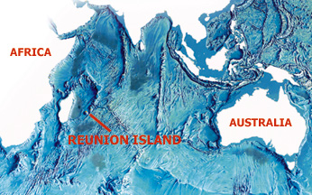
The Piton de la Fournaise volcano on Réunion Island in the Indian Ocean is one of the most active volcanoes in the world. It has erupted an average of once per year over the last century.
| Home | Calendar | Classifieds | Subscribe | Advertise |
| Geotimes
Published by the American Geological Institute |
Newsmagazine
of the Earth Sciences
October 2000 |
| An
eruption at Piton de la Fournaise
by Thomas Staudacher The Piton de la Fournaise volcano on Réunion Island in the Indian Ocean is one of the most active volcanoes in the world. It has erupted an average of once per year over the last century. |
|
Réunion Island is the present-day extension of the Deccan Traps/Réunion hot spot chain, which, when India drifted north before colliding with the Asian continent, started 65 million years ago with a huge flood basalt eruption in west-central India. The chain covers an area of 500,000 square kilometers and contains a sequence of tholeiitic basalt reaching 1.2 kilometers thick.
One of the islands two volcanoes, Piton de la Fournaise sits in the southeast portion of the island in a caldera about 8 kilometers wide called Enclos Fouqué, which was formed 4,200 years ago and lies breached and open to the sea by a huge landslide. Most of the eruptions occur inside this caldera, which directs lava flows away from nearby inhabitants. But some eruptions have occurred outside Enclos Fouqué, most recently in 1977, 1986 and 1998. In 1977, lava partially damaged the village Piton Sainte Rose on the northeast rift zone. In 1986, an eruption destroyed eight houses on the southeast rift zone.
After an unusual quiescence from late 1992 to early 1998, Piton de la Fournaise volcano erupted again for 196 days, with two simultaneous eruptive sites on the north and west flanks and at a third site outside of Enclos Fouqué. After this repose, the volcano returned to its more typical eruptive pattern with two short eruptions on July 19 and Sept. 28 last year and another this year on Feb. 14.
The Piton de la Fournaise volcanic observatory, part of the Institut de Physique du Globe de Paris, has monitored the volcano since 1980. On Sept. 28, 1999, three different teams from the observatory, including the author, took a helicopter to the volcano. We were standing on the caldera rim waiting for the helicopter when our observatory colleagues informed us that a seismic crisis had started. We flew to the central craters Dolomieu and Bory.
At 11:58 a.m. we heard a strong whistling noise from inside Dolomieu crater. One minute later we stood on the crater rim, about 150 meters above the eruption site, where we observed a 10-meter-wide lava fountain shoot 50 meters into the sky from the craters southwest corner. Over the next several minutes, a fissure opened slowly in the craters floor, stretching northwest and emitting white steam and then small lava fountains. After 10 minutes the fissure measured 200 meters long and was terminated by another lava fountain that reached 20 to 30 meters in height. A lava flow advanced into Dolomieu crater. Three fissures then immediately opened en echelon at 2,500 meters altitude on the south flank of Piton de la Fournaise and a very vigorous lava flow ran downslope to reach a spot 300 meters lower in elevation. The lava travelled 1.5 kilometers within 15 minutes, then continued on a more gentle slope until it stopped, eight hours later, between craters Jérémine and Le Gros Bénard. Using a hand-held GPS receiver, we mapped this lava flow the next day.
On Oct. 8, 1999, we observed a serious increase in tremor. First, some new fumaroles appeared to the south of the caldera four kilometers from Dolomieu. Three days later a new lava flow sprouted close to the southern caldera border about 3.5 kilometers from the crater. The main eruption site close to Dolomieu released hot gases for several weeks and tremors continued until Oct. 23. A total of about 1.4 x 10⁶ cubic meters of new lava erupted, most extruding in the first stage of the eruption.
Staudacher works with the Observatoire
Volcanologique du Piton de la Fournaise, Réunion Island Institut
de Physique du Globe de Paris.
| Other
Activity
Earthquake Workers in Californias Napa Valley spent Labor Day cleaning up shattered remains after a quake measuring magnitude 5.2 jolted the states northern wine country on Sept. 3. The quake hit at 1:38 a.m. near Yountville, about 50 miles north of San Francisco, causing at least one serious injury and cutting power to thousands. USGS strong motion instruments recorded unusually high levels of shaking apparently the result of the amplification of shaking by young sediments along the Napa River and the focusing of strong motion to the southeast, the direction the earthquake rupture propagated. A fire station six miles north of the epicenter shook with a horizontal force equivalent to 50 percent of the buildings weight. Flooding Rising river waters threatened to engulf the
Cambodian capital Phnom Penh on Sept. 13. The water level at Chaktomuk,
the point where the Mekong, Bassac and Sap rivers converge in Phnom Penh,
reached nearly 37 feet. At about 38 feet, the water will spill into
the streets, national officials said. Since July, the flood has killed
80 people and cost millions of dollars in property damage.
|
| Earthlinks
www.geophys.washington.edu/seismosurfing.html
|
Christina Reed compiles Geophenomena.
 |
Geotimes Home | AGI Home | Information Services | Geoscience Education | Public Policy | Programs | Publications | Careers |