

Everyone in downtown Hutchinson, a city of 40,000 in central Kansas, heard or felt the natural gas explosion Wednesday morning, Jan. 17.
City Manager Joe Palacioz was meeting with his department heads at City Hall, four blocks away, when they heard the blast and felt the shock wave shake the building. The fire and police chiefs rushed towards the sound of the explosion. Palacioz headed to the citys emergency operations center and would stay there for many days as the crisis unfolded.
This sudden release of natural gas burst from the ground under Woodys Appliance store and the adjacent Décor Shop, blowing out windows in nearby buildings. Customers and workers staggered out into the street from both stores, remarkably only shaken and dazed. Within minutes, the two businesses were ablaze.
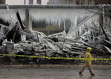
[Right: A firefighter walked past the ice-covered remains of two buildings Jan. 20, after a series of natural gas explosions in Hutchinson, Kan., destroyed them. Since January and during most of this year, geologists from the Kansas State Geological Survey have worked intensely to discover how the gas reached the city. In the process, they lessened public fears, communicated their science to the public, and performed scientific analysis at high speed. AP Photo.]
That evening, geyser-like fountains of natural gas and brine began bubbling up 2 to 3 miles east of the downtown fires. The geysers, some reaching 30 feet high, came from abandoned brine wells that had been drilled as long ago as the 1880s for salt production.
The next day, natural gas coming up a long-forgotten brine well exploded under a mobile home, killing two people. The city ordered hundreds of residences and businesses evacuated. Many people would not be able to return to their homes and businesses until the end of March. The sudden explosions shocked the residents of this important agriculture and petroleum center, home of the Kansas State Fair and a solid Midwestern town of treelined streets and clapboard houses.
Suspicion quickly focused on a catastrophic leak from an underground gas storage field, miles from downtown. Questions immediately arose as to how large amounts of natural gas could move long distances underground in a matter of hours or days. Could we intercept the gas underground before it did more damage to Hutchinson?
In the following months, the state geological survey would work to unravel a geologic mystery.
The
culprit
Eight miles northwest of Hutchinson on Wednesday morning, technicians
at the Yaggy underground natural gas storage field saw a dramatic drop
in pressure in one underground, manmade salt cavern or jug that they
had been filling with natural gas. Almost immediately, everyone looked
at the leaking jug as the source of the gas in Hutchinson. Kansas Geological
Survey engineer Saibal Bhattacharya did some back-of-the-envelope calculations
showing that, under geologically plausible conditions, high-pressure gas
could travel from Yaggy to Hutchinson in a few days. The local natural
gas utility, Kansas Gas Service (KGas), realized that the S-1 jug likely
had been leaking at a low level at least since its pod of jugs had been
refilled three days earlier.
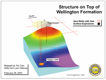
The Yaggy field was originally developed in the early 1980s to hold propane. Wells were drilled to depths of about 650 to 900 feet, into the lower parts of the Permian Hutchinson Salt Member of the Wellington Formation. Each jug was formed by drilling into the salt, pumping down freshwater and removing salty brine. When the field closed in the late 1980s, the wells were cased into the salt and later plugged by partially filling them with concrete.
KGas acquired the facility in the early 1990s and converted it to natural gas storage. The advantage of salt cavern storage is the ability to move large amounts of gas in and out quickly compared to gas storage in depleted oil and gas fields. This allows the facility to serve as a rapid-response source of gas when peak demand occurs, as it did during the cold weather of January.
The Yaggy field could supply about 150 MMcf of gas per day. At the time of the crisis, Yaggy had 62 active gas storage jugs. The field could hold 3.5 billion cubic feet (Bcf) of gas at pressures of about 600 pounds per square inch (psi). The S-1 jug held about 60 million cubic feet (MMcf) of gas.
The survey steps in
Almost from the beginning, the Kansas Geological Survey stepped into
a chaotic situation where information was in great demand and short supply.
The survey became a key player in understanding the natural gas explosions
at Hutchinson by volunteering information and ideas and openly answering
the questions of state and city officials, KGas, and the public.
Three events contributed greatly to the Surveys influence. One was the success of our seismic reflection program in finding good well locations to vent gas. The second was a day-long technical workshop we convened to lay out a coordinated geologic exploration program. As a result of these first two events, a trust developed between the survey and KGas. The utility sought our requests and recommendations for wells, cores, logs and tests, and then acted on them.
The third event was an emotionally charged town hall meeting that was televised throughout the region. The survey presentation and answers to questions was widely acclaimed for bringing the first sense of hope that the crisis would be resolved.
The Kansas Geological Survey is not a state organization, but has a history of being a university-based research organization. Some survey scientists questioned whether our level of involvement was appropriate.
However, overwhelmingly positive recognition from the local citizens and officials, the governor, the University of Kansas Chancellor and the news media largely silenced this debate.
The surveys geophysical crew was preparing to deploy to Arizona for a long-planned cooperative research project with the U.S. Army when our scientists recommended that, if we could postpone our planned Army project, a seismic survey might be the way to salvage the floundering vent well drilling program. On Jan. 30, Kansas Gov. Bill Graves mobilized the Kansas Geological Survey and directed us to aid the citizens of Hutchinson during the crisis. The Army graciously agreed to postpone the field project. In Hutchinson, the governors order was hailed in the local newspaper as if he was sending in the cavalry.
The survey committed its geologists, geophysicists and engineers to the crisis with four goals: (1) make Hutchinson safe from leaking gas; (2) find abandoned brine wells for proper plugging; (3) determine if Yaggy field could be reopened and under what conditions; and (4) determine what the impacts are for natural gas storage in salt caverns nationwide.
The
mystery unfolds
During the first two days of the crisis, our working hypothesis based
on conversations with the Kansas Department of Health and Environment
the regulatory agency in this case was that high-pressure gas leaked
out of well S-1 as a result of casing failure. A down-hole video in S-1
shows a large curved slice in the casing at about 600 feet.
The gas moved vertically up to a laterally continuous, gypsiferous zone that perhaps served as a seal, then spread in all directions due to the pressure. Some of it moved updip due to density-driven flow along a small northwesterly plunging anticline. It made its way to Hutchinson, where it found abandoned brine wells that had been drilled into the salt. Excavations at the original explosion site, for example, found a well in a basement that had been drilled to provide brine waters for a hotel spa. Most wells were only cased down through the shallow Quaternary Equus beds aquifer. The deeper parts of the wells were open-hole and provided paths for the gas to escape to the surface.
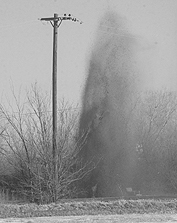
[Right: The largest of several natural gas geysers spewed dirt, water and gas more than 30 feet in the air northwest of the Big Chief Mobile Home Park in Hutchinson, Kan., where a mobile home exploded Jan. 18, killing two people. From The Hutchinson News.]
KGas began to drill wells to find and vent gas to the surface. The first
wells were drilled close to many of the geysers on the east side of Hutchinson,
but no gas was found. In fact, of the first 36 wells drilled in and around
Hutchinson, only eight hit gas.
Survey geologist Lynn Watney examined cores and samples from
wells drilled in the area, but found only relatively impermeable shale
interbedded with thin gypsiferous shales and gypsum beds. Discontinuous
fractures, commonly filled with gypsum, occurred throughout the shale layers
but no zone stood out as a potential gas conduit. Also, isolated channel-form,
estuarine sandstone deposits had been mapped in adjoining Sedgwick County
by KGS associate director Larry Skelton, further adding potential candidates
for conducting the gas.
But gas was present in only about 20 percent of the wells. Why? Was the gas-bearing zone a channel or something similar, even though no channel deposits had been recognized in the immediate area?
Our discussions centered on the need to acquire shallow, high-resolution seismic reflection data to explore for the possible narrow geologic pathways that appeared to be carrying gas selectively under parts of the city.
Finding
the gas pathways
Rick Miller and his geophysical crew ran a four-mile-long seismic reflection
line from north to south between the Yaggy field and the city. Altogether,
60 gigabytes of data were collected and shipped in batches to the survey
offices for expeditious processing by Jianghai Xia. Susan Nissen, working
with Xia and Watney, identified two anomalous zones, 150 feet and 200 feet
wide respectively. They were defined by weaker signals relative to the
adjacent areas; one also had an underlying bright spot.
KGas drilled both seismic anomalies and both found gas at the predicted
locations and depths. Both wells were among the largest gas producers of
all the vent wells eventually drilled. It appeared to the public that we
had solved the mystery.
KGas drilled a core hole within a few tens of feet of one of
the vent wells, specifically to capture a sample of the producing zone.
It turned out to be not a channel but several thin, tight dolomite layers.
These layers were at the equivalent depth of the gas-bearing interval:
below the contact between the Permian Wellington and overlying Ninnescah
Shale about 200 feet above the top of the Hutchinson Salt. We were back
to square one in explaining what the gas pathways were.
Watney and colleagues examined gamma ray logs from the vent wells that led to a revised theory that the gas pathway was composed of dolomite layers that pinched out northeast against shales.
Gas from Yaggy could have moved eastward (updip) through the cleaner, more brittle and possibly fractured dolomites until it ran into the shale permeability barrier that deflected the gas to the southeast and under Hutchinson. The dolomites and surrounding strata have only minor matrix permeability. Thus, the only significant permeability would come from fractures, which were not directly observed in the core.
At this time, we cannot say with certainty that we have correctly identified the conduit or know what it is geologically.
Hutchinson
declared safe
NASA flew two methane-detecting missions after the vent well flow rates
had subsided, to search for any gas seeps that might have been overlooked.
The leaking natural gas was almost entirely methane.
One NASA team led by Hank Revercomb from the University of Wisconsin flew the High-resolution spectral Imaging Spectrometer instrument at high altitudes over the Yaggy-Hutchinson region in late April. They found no significant amounts of methane above normal background levels in the study area. A second instrument, the Airborne Emissions Spectrometer from the Jet Propulsion Laboratory, was deployed to Hutchinson for a 10-day mission in May under the direction of David Rider. Methane was detected in the atmosphere over Hutchinson, but whether it was above the normal background level has not yet been determined.
By mid-March, KGas had drilled every potential target that could be identified. Gas flow rates and pressures in the vent wells continued to decline. We believed we had at least a framework understanding of the geologic mystery, even if we did not know all the details.
At a town hall meeting in Hutchinson on March 29, the survey said that from a geological viewpoint, the city is safe. The next day, the city announced that the last of the evacuees could return home. The message heard by citizens and reported by the newspaper: The crisis was over.
Finding
the brine wells
Once the vent wells had been drilled, we turned greater attention to
finding brine wells. When these wells were abandoned, some were filled
with whatever happened to be handy rocks, bricks or dirt. Some were just
left as they were, open all the way to the salt.
As many as 160 wells are out there, many buried purposely or by subsequent development. The city and the state want to find all the wells and properly plug and abandon them, at an estimated cost of almost $10 million.
Xia took a multi-frequency electromagnetic sensor to Hutchinson to detect the brine wells. In a small test plot, detailed electromagnetic maps were made for each of a suite of different frequencies or, in effect, different depths. Anomalies identified on the maps were dug up by city workers with a backhoe to test the surveys predictions. Survey scientists trained city workers to lay out survey areas and record data. The computer files were sent electronically to the state survey, where they were interpreted and recommendations made for digging. One well was found in the test area.
The
value of geology
Many residents of Hutchinson have demanded that Yaggy be closed and
never re-opened. A two-year moratorium prevents operation of the Yaggy
storage field, pending promulgation of new regulations. Yaggy is one of
30 hubs in the national gas distribution system and one of 27 storage
fields in salt caverns nationwide. It is a key element of gas supply in
central Kansas and has national importance given the tight energy situation.
KGas has expressed concerns about meeting customer demand if this operation
is shut down permanently.
People in Hutchinson desperately wants to know when all the gas will be vented. To answer this, flow rates and pressures are being monitored at vent wells. This information, along with pressure build-up and draw-down tests, can be used to project the time it will take for the gas pressure to drop to the hydrostatic level. At that point, we will consider the gas to be effectively depleted, even though some residual gas will remain.
The Hutchinson gas crisis has been a continuing series of geologic surprises and unexpected complexities. We have a general understanding of what happened and why, but the details and the confirmations are to varying degrees still unknown. This is not merely an academic exercise. Important issues remain about the vulnerability of the city of Hutchinson and the possible reopening of the Yaggy storage field.
Lastly, we want to ensure that this catastrophe never occurs again, either here or at any other location where high-pressure gas is stored underground. Today, eight months after the initial explosion, these questions remain. But we have learned some things.
Everyone involved in the crisis came to quickly value the geologic data and samples the Kansas Geological Survey had collected and archived for decades. Similarly, our scientific expertise, developed over decades, was instantaneously available.
We developed a collaboration with KGas that a regulatory agency likely could not. This cooperation allowed us to propose drilling locations and obtain cores, logs and other data that were critical. Similarly, our practical response provided the regulators with something useful. We became an asset to both sides.
Once the survey was involved, we aggressively released information publicly as we developed it, mainly through a Web site developed by survey scientist Dave Young. News reporters and the public saw the scientific process in action. We developed hypotheses, tested them, and changed our interpretations based on what we found. We appeared at every public meeting. We let the public watch our successes and failures as we made them. We never ducked questions, but at times we admitted that we didnt have the answers.
The combination of relevant geologic investigation and inclusion of
the public in our ongoing inquiry led to widespread public appreciation
of the value of scientists in general and the Kansas Geological Survey
in particular.
Letter To the Editor
November 27, 2001
Dear Editor:
In my article, "Hutchinson, Kansas: A Geologic Detective Story," (Geotimes, October, 2001), reference is made to "a chaotic situation." This referred to our understanding of an elusive geologic pathway that natural gas was following underground, not to the emergency efforts by city, state, and gas utility officials. In fact, the response of the various agencies was quick, effective, and well-coordinated.
M. Lee Allison
Visit the surveys Hutchinson Response Project at www.kgs.ukans.edu/Hydro/Hutch/index.html
 |
Geotimes Home | AGI Home | Information Services | Geoscience Education | Public Policy | Programs | Publications | Careers |