Geotimes
Geophenomena
Finding
disease-carrying mosquitos from space
by Stephen C. Guptill and Chester
G. Moore
After natural disasters inflict wreckage and death on a population,
what often follows is the threat of diseases. After floods, standing freshwater
can become a breeding ground for mosquitoes. Although the chance of a mosquito-born
epidemic following a disaster in the United States is slim, disaster-response
policies require that we monitor such risk.
Vector-borne diseases infectious diseases transmitted by arthropods
are re-emerging as public health threats in the United States. While
some of these diseases have been present for over a century, others are
newly introduced into the country. For example, since 1999, an increasing
number of mosquitoes on the East Coast have been caught carrying the West
Nile virus. But an even more dangerous arboviral disease one that kills
one-third of infected humans lurks in the wetlands of the Gulf Coast.
When floods hit, coupling the epidemiologist's knowledge of disease outbreaks
with geographic information systems (GIS) and remote sensing technology
could help natural disaster relief workers prevent the spread of disease
aftershocks.
 Scientists
at the United States Geological Survey (USGS) and the Centers for Disease
Control and Prevention (CDC) are undertaking a study in the Mobile, Ala.,
area to determine the feasibility of using remote sensing and GIS technologies
as part of a disaster response plan. Such technology may help to establish
the location and extent of a disaster as well as those areas that contain
the hosts of pathogens that cause disease. A key response will also involve
locating all populations at risk and working to reduce the likelihood of
exposure to disease.
Scientists
at the United States Geological Survey (USGS) and the Centers for Disease
Control and Prevention (CDC) are undertaking a study in the Mobile, Ala.,
area to determine the feasibility of using remote sensing and GIS technologies
as part of a disaster response plan. Such technology may help to establish
the location and extent of a disaster as well as those areas that contain
the hosts of pathogens that cause disease. A key response will also involve
locating all populations at risk and working to reduce the likelihood of
exposure to disease.
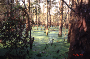
[This picture of a freshwater
swamp habitat of eastern equine encephalomyelitis in North Carolina was
taken after Hurricane Fran hit the state in 1996. Courtesy of R.S. Nasci,
Centers for Disease Control and Prevention.]
The major post-disaster disease risk in the Mobile study area is from
eastern equine encephalomyelitis (EEE), an often-fatal inflammation of
the brain and spinal cord. Carried by mosquitoes, the disease occurs in
focal locations along the eastern seaboard, the Gulf Coast and some inland
Midwestern locations of the United States. Small outbreaks of human disease
have occurred in the United States, and outbreaks among horses can be a
common occurrence during the summer and fall. Humans develop symptoms four
to 10 days after being bitten by an infected mosquito. These symptoms begin
with a sudden onset of fever, general muscle pains and a headache of increasing
severity. Many individuals will progress to more severe symptoms such as
seizures and coma. About one-third of all people with clinical encephalitis
caused by EEE will die from the disease. Of those who recover, many will
suffer permanent brain damage, with many of those requiring permanent institutional
care.
The EEE virus also can produce severe disease in horses; some birds,
such as pheasants, quail, ostriches and emus; and even puppies. The whooping
crane, an endangered species, is highly susceptible to EEE. Cases in horses
usually precede those in humans, making horse cases a good surveillance
tool.
After a flood event, the numbers of mosquitoes may dramatically increase.
Culiseta melanura mosquitoes transmit the EEE virus among avian hosts.
But the EEE virus may escape from the wetland via birds or such bridge
vectors as the freshwater mosquito Coquillettidia perturbans and the eastern
salt marsh mosquito Aedes sollicitans. These species feed on both birds
and mammals and can transmit the virus to humans, horses and other hosts.
The disease investigator's challenge after a flood is to locate areas
of likely habitat for these and other mosquito species, then determine
their abundance and whether they are carrying a virus.
 Locating
the areas that contain the hosts of disease agents is a multi-faceted problem.
Remote sensing technology can help to determine the geographic extent and
severity of a disaster. Comparing modern imagery with archival data helps
to determine the magnitude of the damage. In the case of this study, we
are particularly interested in the extent of flooding resulting from
a Gulf Coast hurricane, for example. If clouds are not obscuring the ground,
high-resolution images (pixels 15 meters in size or smaller) from satellites
or aircraft can detect these flood boundaries. Should cloud cover be a
problem, radar sensors can penetrate the cloud cover and provide good discrimination
of the land and water boundary despite their coarser spatial resolution.
Locating
the areas that contain the hosts of disease agents is a multi-faceted problem.
Remote sensing technology can help to determine the geographic extent and
severity of a disaster. Comparing modern imagery with archival data helps
to determine the magnitude of the damage. In the case of this study, we
are particularly interested in the extent of flooding resulting from
a Gulf Coast hurricane, for example. If clouds are not obscuring the ground,
high-resolution images (pixels 15 meters in size or smaller) from satellites
or aircraft can detect these flood boundaries. Should cloud cover be a
problem, radar sensors can penetrate the cloud cover and provide good discrimination
of the land and water boundary despite their coarser spatial resolution.
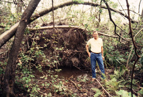
[Entomologist Charles Anderson
with the Louisiana Department of Health and Hospitals stands beside a water-filled
pit created when hurricane Andrew uprooted trees in southern Louisiana
in 1992. Large numbers of larval habitats can form when trees are uprooted.
Courtesy of C.G. Moore, Centers for Disease Control.]
The remote sensing data is then combined with other geospatial information
in a GIS. For the Mobile area, we have constructed a GIS database that
contains multi-resolution land cover data, digital imagery from Landsat
7 and digital orthophoto quads, National Wetlands Inventory data, digital
elevation data, digital soils information, hydrography and transportation
information, and census data.
From these data, we can determine which areas mosquitoes will most likely
inhabit, such as vegetated fresh-water wetlands and areas of bog or muck
soil. Ideally, seven to 10 days after the peak flood, imagery would be
acquired to see if the flooding has created or removed habitats favorable
for mosquitoes. Additionally, the imagery would show if areas of potential
habitat are accessible via ground transportation, or if watercraft must
be used. With this information, the field entomologists can deploy their
mosquito traps in areas where mosquitoes are most likely to live. The captured
mosquitoes are then tested to see if they carry disease pathogens.
The locations of any pools containing virus-infected mosquitoes are
then analyzed in the GIS with respect to the distribution of the human
population. Clearly, infected mosquitoes located close to large numbers
of susceptible humans pose a greater risk than mosquitoes that are miles
from most of the population. While this analysis can be done with existing
census data, in an emergency situation adjustments must be made for temporary
population redistributions, such as to shelters at high schools. If limited
resources are available for intervention and mitigation spraying of insecticides
to kill adult mosquitoes, application of larvicides then the areas of
mosquito habitat that pose the greatest risk can be targeted first.
Guptill is with the
U. S. Geological Survey in Reston, Va. E-mail: sguptill@usgs.gov
Moore is with Division of Vector-Borne
Infectious Diseases at the Centers for Disease Control and Prevention in
Fort Collins, Colo. E-mail: cgm2@cdc.gov
For additional reading, visit www.cdc.gov/ncidod/dvbid/arbor/arbdet.htm
