Geotimes

Feature
The Urban Evolution
of U.S. Earthquake Monitoring
Lisa M. Pinsker
Sidebar: More
than earthquakes
A tour through the old Kresge Seismo Lab, the original home of Southern California
earthquake research, feels a lot like a late-night walk through a haunted house.
No, you cannot hear the walls whistling; the thick concrete walls insulate the
building from almost all sound. But you can smell its legacy, touch the artifacts
and almost see the ghosts of its rich past. Cool and damp from moisture creeping
down from the Pasadena hills, the lab has its own voice and texture. Cobwebs hang
from entranceways that lead to halls with full drawers of seismograph recordings
dating back to 1932. Carefully reach your hands into a cabinet and find a 1969
Science reprint of a paper by Charles Richter, one of the lab’s original
researchers. A walk down a dark corridor likely will land you in a musty room
with seismic instruments anchored deep into the ground. Next door, you can almost
hear the excited shouts of researchers in the old photo lab when they developed
seismic film from the latest earthquake. The red darkroom lights still work, eerily
beaming down on the abandoned equipment.
The times of isolated seismic labs are gone. Walking through a modern seismic
lab now feels, sounds and looks most like a computer lab. Computers have replaced
the photo labs of old. Programmers, not field workers, are carving out new ways
to process and understand earthquake data. Seismologists carry with them beepers
and cell phones that automatically alert them to large earthquakes, allowing earthquake
monitoring to happen from virtually anywhere in the world.
Established by Harry Wood in 1921, the Kresge Seismo Lab was the place
to monitor and study earthquakes in Southern California until 1974, when the lab
moved to the nearby Caltech campus. Much has changed since the days Wood, Charles
Richter, John Anderson and Beno Gutenberg were knocking around Kresge at the cutting
edge of seismology. They envisioned a future where earthquake prediction would
be possible. Today, the goal of earthquake monitoring is instead to mitigate risk
— using better instruments to understand shaking damage and to help engineers
create sounder structures. Researchers now are working not to predict quakes,
but rather to provide warning when earthquake shaking is on its way.
Networks of strong- and weak-motion monitoring systems feed data to the new-generation
seismologists as earthquakes occur. In just the last 30 years, 16 regional networks
have sprouted across the country. The regional seismologists working for the networks
analyze and distribute data from hundreds of seismic monitoring stations and provide
local expertise on earthquake hazards. In addition, the National Earthquake Information
Center (NEIC) in Golden, Colo., provides monitoring for areas that do not have
regional coverage as well as individual reports of all large seismic events worldwide.
Southern California led the nation in this technological revolution in earthquake
monitoring and now is showing the way for a national system that has struggled
for funding over the past five years. The Advanced National Seismic System (ANSS),
capitalizing on the experience from the California region, will update all regional
networks and cooperatively link them to create a single network for the nation.
An urban revolution
 In 1977, Congress
authorized the creation of the National Earthquake Hazards Reduction Program
(NEHRP), a joint effort of the Federal Emergency Management Agency (FEMA), the
National Institute of Standards and Technology, the National Science Foundation
and the U.S. Geological Survey (USGS). The legislation gave USGS the responsibility
for monitoring earthquakes nationwide. Since that time, USGS has assessed and
monitored earthquake hazards through the regional seismic networks and the NEIC.
In 1977, Congress
authorized the creation of the National Earthquake Hazards Reduction Program
(NEHRP), a joint effort of the Federal Emergency Management Agency (FEMA), the
National Institute of Standards and Technology, the National Science Foundation
and the U.S. Geological Survey (USGS). The legislation gave USGS the responsibility
for monitoring earthquakes nationwide. Since that time, USGS has assessed and
monitored earthquake hazards through the regional seismic networks and the NEIC.
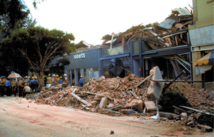
At rush hour on Oct. 17, 1989, as more
than 62,000 fans filled Candlestick Park for the third game of the World Series,
a magnitude-7.1 earthquake struck about 60 miles south of San Francisco. The
effects of the 20-second quake spread across the area, causing as much as $10
billion in in damage, with $2 billion of damage in San Francisco. Sixty-two
people died. The collapse of several structures at the Pacific Garden Mall in
Santa Cruz, shown here, had rescue workers scrambling to find victims. C.E.
Meyer, USGS
Most seismic networks developed in the 1960s and 1970s to study the distribution
and characteristics of small to moderate-sized earthquakes. The original equipment
consisted of a weak-motion seismometer coupled with a recording system. These
old, analog instruments had a recording range of three magnitude units. For
example, a seismometer designed to record magnitude-2.0 earthquakes would “clip”
a signal that came in at magnitude 6.0. Seismologists were then mostly interested
in recording the numbers of earthquakes. Only engineers were interested in measuring
the ground motion associated with larger earthquakes. They would place strong
motion instruments into buildings and then spend up to a year processing data
after earthquakes to measure their effects.
Seismologists would choose remote locations in which to place their weak-motion
seismometers. “So rather than putting seismometers in downtown Washington,
D.C., we would try to put them in the Blue Ridge Mountains, where there was
lower background noise,” says John Filson, coordinator of the USGS Earthquake
Hazards Program. An instrument in the Blue Ridge could tell seismologists much
about the nature of earthquakes, but provide little data on strong ground shaking
and the potential damage associated with urban quakes.
Modern seismographs are now broadband — recording both weak and strong
motion, up to six orders of magnitude. And, in a major philosophical shift,
seismologists have come to realize the importance of the urban monitoring of
earthquakes. “It’s okay to have some seismometers in the Blue Ridge,
but it’s very important to have seismometers in the cities,” Filson
says. Seismologists need to understand the nature of ground shaking in cities
to create earthquake-resistant buildings, and to be able to map and understand
the severity of shaking in an urban area after an earthquake.
With these new technological capabilities in mind, Filson and others at USGS
decided that the United States needed a complete modernization and expansion
of its seismic networks, particularly in urban areas. “We needed to modernize
the types of instruments. And we needed to expand the number of instruments
in urban areas,” Filson says. In 1997, during NEHRP’s reauthorization
process, Congress asked USGS to prepare an assessment of the status and needs
of earthquake monitoring.
The resulting report called for 7,000 new seismic instruments, with 6,000 of
these strong-motion sensors in 26 at-risk urban areas. About half of these urban
instruments would sit in buildings and structures. USGS also expressed the need
to integrate all regional and national networks into one system, which would
be ANSS, “so that the software they’re using in Southern California
to measure magnitudes is the same as the software in Memphis, Utah and Seattle,”
Filson says.
In 1999, Congress authorized the full funding of ANSS for $30 million each year
for five years, 2002 through 2006. But, Filson says, “Authorization opens
the bank account and says that this is a good idea, but it doesn’t put
any money in the account.” To date, the $170 million ANSS project is at
about 10 percent funding. Last year, Congress appropriated about $3.9 million
for this year’s ANSS budget.
“Appropriators have followed the lead of the administrations,” says
a key appropriations staff member in the House of Representatives. Both Presidents
Clinton and Bush requested funding for ANSS at a tenth of its authorized amount.
Generally, the lack of funding has nothing to do with the value of the program,
but rather represents a budgetary decision to cut costs. Until the next major
U.S. earthquake, the House staffer explains, ANSS will likely remain off the
budgetary radar screen.
USGS is trying to make the most of that 10 percent, however, by purchasing a
few new instruments at a time for high-risk urban areas. Last year, ANSS money
purchased 10 new instruments for Anchorage. The plan calls for about 300 strong-motion
sensors there. Just this year, in time for the 2002 Winter Olympic Games, the
Salt Lake City area gained 40 new strong-motion sites to monitor earthquakes
along the Wasatch Front urban corridor (Geotimes, March 2002). Little
by little, ANSS is trying to build its way toward national urban earthquake
monitoring.
California dreamin’
Despite its lack of funding, ANSS has garnered the attention and support of
regional seismologists across the country. ANSS will have a national center,
likely co-located with the NEIC in Golden, but its success will depend largely
on the cooperative efforts of the already existing regional networks. “While
large damaging earthquakes that occur within the United States and its territories
are a national problem, their immediate impact is local. The regional centers
are the direct contact to local, regional and state emergency response communities
and end-users of seismic monitoring products and services,” says Harley
Benz, ANSS manager.
The best place to look to find out how ANSS will play out after completion is
an already fully operating regional network. The USGS Pasadena office is just
one regional center where researchers are working arduously to bring ANSS closer
to reality. The entire history of Southern California’s regional seismic
network, as told by Lucy Jones, scientist-in-charge of the USGS Pasadena office,
sounds like an alphabet soup imbedded in a tale of technological evolution,
funding challenges and political barriers. Sound familiar? Indeed, Jones says
the ANSS project is essentially taking their regional idea nationwide.
Starting in 1997, Caltech, USGS and the California Division of Mines and Geology
teamed up to create TriNet. Each organization had been operating separate seismic
networks for decades. The idea behind TriNet, like ANSS, was to leverage the
resources of many groups into one, to modernize seismic instrumentation in Southern
California.
Until then, the region, like most others, had only a handful of modern, broadband,
digital seismographs. “It used to be that if we could get the information
out in a few hours, that was really good,” Jones says. When the magnitude-6.7
Northridge earthquake hit the Los Angeles area on Jan. 17, 1994, they realized
a few hours wasn’t good enough. Although Northridge caused few casualties,
it incurred $20 billion in damage, and, Jones says, USGS was not prepared.
So FEMA stepped in to fund TriNet, which would install 600 seismograph stations
and end up motivating new technologies to monitor urban earthquakes, including
mapping programs that show the extent of ground shaking. Like ANSS, TriNet focused
on expanding earthquake monitoring to buildings by bringing together seismologists
and engineers, who traditionally have worked separately.
Last year, TriNet’s funding for earthquake mitigation in Southern California
ended, and now Southern California is joining forces with Northern California
in the California Integrated Seismic Network (CISN). Collaborating with the
University of California at Berkeley and USGS at Menlo Park, CISN is providing
another testing ground for taking TriNet to a grander scale: statewide. CISN
is now the California regional network for ANSS.
This move is forcing Southern California and Northern California to work together
in ways they never have before. Historically, a straight line called the Gutenberg-Byerly
line has seismically divided the state into two networks, mostly because the
region is so large. With advances in digital technology, this line has become
outdated; distance does not affect the ability to access data. However, a major
challenge facing CISN is finding a way for the seismic data to “cross that
line” and join together the two networks — once again mirroring ANSS’
challenge to create multiple points of information sharing and redundancy. That
way, if an earthquake incapacitates the Pasadena office, for example, the USGS
at Menlo Park would be fully equipped to analyze the data and communicate it
to the public. The ANSS national office would provide another point of redundancy.
The idea of redundancy is one that Doug Given, the USGS manager of CISN for
Southern California, is working on for both California and ANSS. For an earthquake
that occurs around the border of the Gutenberg-Byerly line, for example, he
is developing a protocol to decide which network, North or South, will report
the quake to the public. In the past, Given says, situations like that have
created friction between the networks and institutions. “It’s not
just pettiness between the groups; it confuses the public,” he says.
For ANSS, each regional network and the national center in Golden need to be
able to report the same magnitude earthquake, requiring standardized software
and data management, Given says. How centralized the system will be has yet
to be determined. Given favors a more distributed system of redundancy, rather
than totally streamlining the data to a central point. That way, regional systems
can exchange data, but still work in individual environments that foster innovation.
In California, CISN has its work cut out to create synchronized yet individual
systems, but Given is hopeful that their hard work in California will pay off
and help create a model for other ANSS regions. “If California can get
together as a region, anywhere can.”
Shaking it up
On the year anniversary of the Northridge quake, another, more deadly earthquake
struck Kobe, Japan, killing more than 6,000 people. Filson spoke with the head
of emergency management for Kobe a couple years after the quake and asked him
what he would have liked to have known that he did not. “He said ‘I
didn’t know the scope of the problem, so I had so many ambulances, fire
trucks and crews to send out on a first-come, first-serve basis. By the time
I realized how big the problem was I didn’t have anything else to send,’”
Filson recalls.
Recognizing the same problem after Northridge, USGS shifted its focus toward
processing earthquake information faster. So, USGS scientist David Wald led
the development of ShakeMap — a rapidly generated computer map that shows
the location, severity and extent of strong ground shaking within only five
minutes after an earthquake. The information, generated by data from seismic
instruments in urban areas, then goes automatically to the program’s Web
site and directly to emergency managers. “It allows us to better portray
both the shaking and the potential damage,” Wald says.
ShakeMap has the potential to revolutionize the response time of emergency managers
to an earthquake, but its success depends on further deployment of instruments.
As it modernizes seismic networks, ANSS hopes to enable ShakeMap in every seismically
active urban area, as it did for the Winter Olympics in Salt Lake City this
year. “Because many parts of California and the nation are sparsely covered
by seismographs and because the underlying geology is so complex, the resulting
ShakeMaps [in these areas] are of limited value in emergency response,”
wrote Tony Shakal of the California Division of Mines and Geology in the agency’s
newsletter last year.
USGS has created ShakeMaps for moderate-sized earthquakes in California and
the Pacific Northwest, as well as for the larger Nisqually earthquake that hit
the Seattle area in February 2001. Anchorage is now receiving new instruments
through ANSS and is working with USGS to install ShakeMap software. Wald is
working to set up a remotely operated system whereby the Pasadena office, for
example, can produce maps with the seismic information collected in Alaska in
addition to the local area itself, creating more redundancy.
Better buildings
Measuring the full range of ground shaking in real time with seismometers in
both remote and urban regions has made ShakeMap possible, created the ability
to monitor structural shaking in real time, and thus combined the often diverging
seismic goals of engineers and seismologists, Given says. TriNet was the first
initiative to bring engineers and seismologists together to study both weak
and strong motion. “This kind of incursion into strong motion is a relatively
new endeavor [for seismologists],” Given says, but one that can change
the way engineers build earthquake-ready structures.
Earthquake engineer Erdill Safak of USGS has been studying ground shaking in
two multi-story buildings. The nine-story Millikan Library at Caltech has 36
strong-motion sensors, and the 17-story Factor Building at the University of
California-Los Angeles has 72 instruments. While both instrumentations are complete,
they are not yet recording data in real time. However, that will change in the
next few months, as ANSS funds will install telemetry capabilities into Millikan,
allowing researchers to gather real-time data. Given says that the data will
be able to tell researchers much about the “fragility” of a building
both before and after an earthquake, as well as tell emergency managers and
engineers where to go to mitigate the worst damage.
Down the line, Given says, this sort of real-time instrumentation could appear
in other structures, like dams and pipelines. Many such structures already have
non-telemetry, strong-motion sensors. “What’s new is not figuring
out what happened days later, but knowing what happened minutes later,”
he says. In Japan, for example, which has a very dense seismic network, detection
of an offshore earthquake or ground shaking will shut down the Bullet Train.
Japan’s system is also allowing seismologists there to more realistically
pursue early warnings of earthquakes.
Early warning
ANSS seismologists would also like to explore ways to give any early warning
of ground shaking in urban areas. “This is one application of ANSS that
is high and out there on the horizon,” Filson says.
If an earthquake occurs along the San Andreas, he explains, 50 miles from downtown
Los Angeles, and its waves are moving at two miles per second, then the network
has 25 seconds to get the data, analyze it and then broadcast it as an early
warning for Los Angeles residents. “Technically, it’s possible.”
Indeed, according to research published in last month’s Bulletin of
the Seismological Society of America, it is possible to warn large urban
centers that strong ground shaking is coming, if the earthquake’s epicenter
is far enough away from the city. Even 20 seconds, notes lead author Ta-liang
Teng of the Southern California Earthquake Center, is enough time to shut off
main gas pipelines.
Teng and his colleagues tested the early warning capability in Taiwan over a
seven-month period using a “virtual subnetwork.” During that time,
the system correctly detected and reported 54 earthquakes between magnitudes
3.5 and 6.3, with an average of 22 seconds between the initiation of the earthquake
and the issuance of a warning. Teng suggests that a modern, integrated seismic
network for the United States would make a similar system feasible — a
possibility Filson and others at USGS have been keenly aware of throughout the
development of ANSS.
One of the biggest advantages of such an early warning system, Filson says,
would be in the classrooms. The Northridge earthquake occurred at 4:30 a.m.
local time. “After the Northridge earthquake, people walked through some
of the schools and saw fallen bookshelves, light fixtures, television sets.
… If kids had been in classrooms, the fatalities would have gone up,”
Filson says. If the quake had occurred later in the day, an early warning of
even a few seconds would have given children enough time to get under their
desks.
With full funding to instrument urban areas nationally, Filson believes it is
possible to better prepare U.S. cities for the unexpected nature of Earth’s
movements. Now the main challenges, Filson says, are societal and financial:
convincing people of the benefits of investing in earthquake hazard mitigation.
While ANSS represents a change in goals from those formed back at Kresge more
than 80 years ago, its possibilities would make Richter, Gutenberg and Wood
proud. Their legacy has taken modern seismology to a new level of technological
capability. The ultimate goal remains the same: to save lives.
More
than earthquakes
 Earthquake
monitoring is not the only field that will benefit from the Advanced National
Seismic System (ANSS); so too will the investigation of exotic seismic events
— unexpected, manmade sources that create seismic signals. Terry Wallace
of the University of Arizona, who has analyzed seismic signals from the
sinking of the Russian submarine Kursk in 2000 (Geotimes, February
2001) and from the 1998 bombing of the U.S. Embassy in Nairobi, Kenya, says
that the modernized national coverage promised by ANSS holds great potential
for the burgeoning field of forensic seismology — the more instruments
out recording seismic signals, the more “ears to the ground” (Geotimes,
August 2002). Earthquake
monitoring is not the only field that will benefit from the Advanced National
Seismic System (ANSS); so too will the investigation of exotic seismic events
— unexpected, manmade sources that create seismic signals. Terry Wallace
of the University of Arizona, who has analyzed seismic signals from the
sinking of the Russian submarine Kursk in 2000 (Geotimes, February
2001) and from the 1998 bombing of the U.S. Embassy in Nairobi, Kenya, says
that the modernized national coverage promised by ANSS holds great potential
for the burgeoning field of forensic seismology — the more instruments
out recording seismic signals, the more “ears to the ground” (Geotimes,
August 2002).
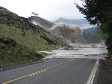
The Cowlitz County PUD’s Swift Power Canal collapsed on April 21, destroying
a section of Washington State Route 530. Seismologists for the Pacific Northwest
Seismic Network (PNSN) are analyzing the seismic signals generated by the
collapse to help determine what exactly caused the accident. PNSN is one
of the regional networks for the Advanced National Seismic System. Terry
Low, PacifiCorp
Wallace points to a recent seismic analysis conducted by the Pacific Northwest
Seismograph Network (PNSN), which is the northwest region for ANSS, to study
the collapse of the Swift Reservoir Power Canal near Mount St. Helens in
Washington State. On April 21, 2002, the canal collapsed, spilling out almost
800 million gallons of water and washing out part of a state highway in
a matter of hours.
In the investigation currently underway to determine the exact cause of
the canal 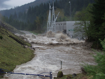 failure,
the PNSN seismic analysis is helping to pinpoint the timing of the events
that weakened the canal’s integrity. Around and after 6:30 a.m., several
bursts of energy occurred against an increase in seismic background levels,
indicating the initial failure of the canal. These background signals died
off over the following 15 minutes. The seismic signal recorded at about
6:56 a.m. was strong enough on several PNSN stations to trigger an automatic
earthquake locator. That signal represents the final failure that caused
the sudden collapse. The PNSN signal analysis corroborated the water-level
reports provided by the Cascade Volcano Observatory and eyewitness accounts
of the event. failure,
the PNSN seismic analysis is helping to pinpoint the timing of the events
that weakened the canal’s integrity. Around and after 6:30 a.m., several
bursts of energy occurred against an increase in seismic background levels,
indicating the initial failure of the canal. These background signals died
off over the following 15 minutes. The seismic signal recorded at about
6:56 a.m. was strong enough on several PNSN stations to trigger an automatic
earthquake locator. That signal represents the final failure that caused
the sudden collapse. The PNSN signal analysis corroborated the water-level
reports provided by the Cascade Volcano Observatory and eyewitness accounts
of the event.
The Swift Power canal collapse inundated
the Swift 2 Powerhouse. An evaluation is underway by Cowlitz County PUD
to determine if portions of the powerhouse can be salvaged. There is also
an investigation underway to determine the exact cause of the canal failure.Terry
Low, PacifiCorp
“This incident shows the value of seismic instrumentation for purposes
beyond earthquake monitoring,” says Robert Norris, a USGS seismologist
at the University of Washington, who worked with PNSN seismologists to interpret
the canal collapse seismogram. Norris is now working to get water-level
data from the reservoir operators for the morning of the collapse. “It
would be interesting to plot the time history of the water level along with
the seismic data.”
Early evidence suggests that a sinkhole connected with lava tubes, produced
by Mount St. Helens, behind the canal wall may have been a factor. Ultimately,
the PNSN data could help investigators piece together what happened at the
canal.
Lisa M. Pinsker
Back to main story |
Pinsker
is the staff writer for Geotimes. E-mail
