Geotimes

Feature
Digging up Boston:
The Big Dig Builds on Centuries of Geological Engineering
Bradford A. Miller
Special Web sidebar:
Urban Fill: Everything Including the Kitchen Sink
 The
“Big Dig” in Boston, Mass., is one of the most challenging and complex
heavy construction projects ever undertaken. Formally called the Central Artery/Third
Harbor Tunnel, or CA/T, project, the Big Dig takes on a formidable challenge:
to construct a below ground superhighway beneath an active, but aging, six-lane
elevated highway that must remain in service 24/7 — keeping the city open
for business — and to build a third tunnel beneath Boston Harbor; all while
working within complex subsurface geology and applying advanced engineering
solutions.
The
“Big Dig” in Boston, Mass., is one of the most challenging and complex
heavy construction projects ever undertaken. Formally called the Central Artery/Third
Harbor Tunnel, or CA/T, project, the Big Dig takes on a formidable challenge:
to construct a below ground superhighway beneath an active, but aging, six-lane
elevated highway that must remain in service 24/7 — keeping the city open
for business — and to build a third tunnel beneath Boston Harbor; all while
working within complex subsurface geology and applying advanced engineering
solutions.
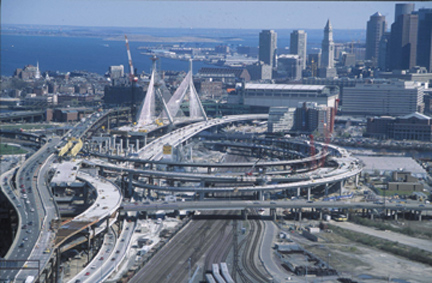
The view southeast toward Boston
Harbor highlights the Zakim Bridge, roadways and ramps under construction across
the Charles River. The soon-to-be replaced, elevated I-93 interstate highway
is on the left. Downtown Boston is at the right-center of the image. In the
distance, the twin hills of Spectacle Island rise to form new harbor parkland.
Supplemented with excavated Big Dig soils as landfill cover, Spectacle Island
was once the site of a municipal waste dump and rendering plant. Image courtesy
of CA/T Project and Bechtel/Parsons Brinckerhoff
However, the challenge faced by the Big Dig constructors is only a recent example
of how the subsurface conditions and complex geology in the Boston area have
influenced and controlled the development of the city and its built environment;
and also contributed to the development of the disciplines of engineering geology,
geotechnical engineering and several aspects of modern construction practice.
Boston’s blessing has been its extraordinary coastal setting. The Town
of Boston was originally founded on the small, 789-acre Shawmut Peninsula, a
highland connected by a narrow neck to the mainland that high tides often breached.
By 1623, early English settlers recognized that the area hosted defensible promontories,
a deepwater harbor, abundant shellfish and the potential for marine trade.
In his 1989 article “History of Boston: The Impact of Geology,” engineering
geologist David Woodhouse summarized several geologic factors affecting the
founding, and growth, of the city. First, the indented coastline of Massachusetts
was the result of glacial erosion of the underlying softer bedrock, generally
formed of the Cambridge “argillite,” a weakly metamorphosed, laminated,
late-Proterozoic mudstone. The erosion provided the natural topographic basin
that was later flooded following the end of the Wisconsinan glacial period and
subsequent rise in eustatic sea level. Second, prominent glacial landforms,
principally drumlins, exposed marine clays and granular glaciofluvial “outwash”
features — as well as complex, puzzling moraines exhibiting deformed and
folded sediments, such as Beacon Hill — created features that could function
as natural defenses from seagoing enemies. Third, natural springs and good quality
water in shallow dug wells sustained the town, providing enough for the initial
settlements until the population substantially increased.
Colonial streetscapes developed around the irregular topography and coastline.
As the city grew, so did the harborfront and coastline. The shallow tidal bays,
coves and marshlands became logical areas to fill in, creating “made land.”
By the early 1800s, the geography and settlement patterns began to expand toward
the surrounding areas as the city’s growth accommodated the geological
setting.
The confluence of education, geology
and engineering
As the city of Boston grew in national influence, the educational institutions
of Massachusetts and New England attracted 19th century geologists such as Edward
Hitchcock (1830s), William Otis Crosby (1880s), Nathaniel Shaler (1890s) and
J.B. Woodworth (1900). But the academic and practical understanding of the interaction
between geology and engineered structures remained relatively unrefined until
the late 1890s.
Through the 1870s, early area buildings, bridges and other structures utilized
comparatively simple soil-supported foundations. These were usually constructed
on brick or mortared stone footings. Later, tapered wood-piles driven into the
desiccated, stiffer marine clays commonly supported waterfront structures (Parkhill,
1998).
Many of these 19th-century buildings remain in downtown Boston, often reused
for elegant office or residential space. A significant construction challenge
facing today’s geotechnical engineers, particularly along the route of
the Big Dig, is anticipating and mitigating potential construction impacts to
these delicate masonry structures. Sophisticated instrumentation installed along
the new construction route allow engineers to measure and respond to potential
ground movements, utility conduit deflections, and vibration impacts to other
structures well before damage can occur.
In the early 20th century United States, the discipline of foundation engineering
grew along with rapid growth in urban areas, including New York, Chicago and
San Francisco. In Boston, emigration, industrial advances, desire for larger
buildings and the economic expansion occurring between 1880 and the mid-1920s
fueled demands for new construction on filled lands outside the old urban core.
The core then was suitably underlain by typically dense, stable glacial soils.
The “made land” — marginal by itself even for simple construction
purposes — was often a combination of unstable fill soils, soft organic
peats and silts, and thick compressible marine clay. If loaded beyond a certain
point, these materials could potentially deform, leading to settlement of the
structure with consequent shifting and likely damage.
Although not alone in recognizing the influence of geology on urban foundation
construction at the time, geologist Irving B. Crosby published engineering geology
maps in the early 20th century, including possibly the first detailed seismic
studies of an urbanized area (in 1903 and 1932) that depicted relative stability
of the local terrain to earthquake-induced ground motions. And as twists of
fate often turn, differential settlement observed in the foundations of what
was then the new Massachusetts Institute of Technology (MIT) campus in Cambridge
attracted the interest of scientist Karl Terzaghi following his arrival at MIT
in 1925. By the early 1930s, Terzaghi and Arthur Casagrande examined the relationship
between laboratory experiments on the strengths and properties of undisturbed
cohesive soils (among them the Boston Blue Clay) and the predictions for how
these soils would behave under construction conditions. Their careful analyses
of cohesive soil strengths and characteristics of other soils identified general
soil properties, behaviors and limitations that were formative to the discipline
of soil mechanics. Many of the early theories of soil mechanics are still applicable
to major constructed works and deep excavations worldwide, including the Big
Dig.
These challenging subsurface conditions, directly or indirectly, made Boston
one of the educational centers for the nascent sciences of soil mechanics and
engineering geology, offshoots of the established disciplines of civil engineering
and “traditional” geology.
Foundations go deeper
With the construction of larger buildings in the 1940s and 1950s, foundations
had to stretch from the soil, or overburden, down into the deeper glacial soils
and bedrock. Geologic investigations were limited to exploratory soil borings
and diamond core drilling methods performed for geotechnical design purposes.
Drilling typically evaluated the characteristics of only the upper five to 10
feet of the bedrock.
A comprehensive understanding of the structure of the Boston Bay Group bedrock
— which primarily hosts Precambrian argillites, sandstones, conglomerates,
“tillites,” volcanic materials, and younger crosscutting mafic dikes
— remained elusive. Most of the bedrock surface was masked beneath thick
overburden deposits, as outcrops near the center of the Boston basin were nonexistent.
However, in the 1950s, further complexities in the deep bedrock basin structure
were revealed and examined in several bedrock water supply and sewer infrastructure
tunnels constructed under the supervision of the Metropolitan District Commission.
Most of the Dorchester Tunnel was reportedly driven employing the first application
of a mechanized, tunnel-boring machine (TBM), now a commonly used construction
technique for both soil and bedrock tunnels.
According to Woodhouse, less than ideal bedrock conditions were observed in
sections of almost all of these tunnels studied. To differing degrees, the areas
included softer, kaolinized, and decomposed bedrock resulting from likely hydrothermal
alteration, which were often affiliated with major shear zones, breccias, fault
gouge or fault zones. The structurally weaker rock was accommodated within the
tunnels by concrete lining, steel supports, rock bolts or other construction
methods. Again, the construction techniques responded to the problematic ground
conditions.
In the 1960s and 1970s, presaging the future building boom to come in Boston,
foundations became more complex and were constructed by a variety of methods:
machine-excavated straight shaft and belled caissons replaced the dangerous
hand-excavation methods. Precast-prestressed concrete piles replaced the more
costly steel pipe piles, and, in 1976, the advent of “slurry wall”
excavation support method arrived in Boston. With the downtown real estate development
boom in the early 1980s, the need for deeper excavations and foundation systems
yielded additional insight into the soils and bedrock below the city. And the
extensive subsurface explorations for the publicly funded CA/T and Deer Island
Outfall Tunnel provided rock cores that are available for examination outside
the engineering and engineering geology community.
Now: the Big Dig
In a league by itself for magnitude, the Big Dig consists of almost 168 total
lane-miles of highway and ramp access, about half of that in tunnels. As in
the past, CA/T construction designers and engineers contend with complex geological
conditions that vary in both lateral extent and with increasing depth. And while
the range of anticipated subsurface conditions identified by early explorations
and historical foundation construction experience can be beneficially applied
to the CA/T project, geotechnical designers still require detailed geologic
information at the locations of each engineered structure.
 Important
engineering attributes of the soils include the thickness and content of the
fill materials, presence of compressible organic soils, and strength and stability
of the often thick cohesive marine and glaciomarine clays. Also important is
identifying the presence of dense glacial tills that might provide suitable
deep structural support, and determining the depth, overall competency and strength
of the bedrock. Designers must accommodate the presence of groundwater and minimize
the effects that construction dewatering in a deep excavation could have on
adjacent ground stability. Understanding the characteristics and engineering
behaviors of the individual stratigraphic units is critically important for
large infrastructure works such as the Big Dig.
Important
engineering attributes of the soils include the thickness and content of the
fill materials, presence of compressible organic soils, and strength and stability
of the often thick cohesive marine and glaciomarine clays. Also important is
identifying the presence of dense glacial tills that might provide suitable
deep structural support, and determining the depth, overall competency and strength
of the bedrock. Designers must accommodate the presence of groundwater and minimize
the effects that construction dewatering in a deep excavation could have on
adjacent ground stability. Understanding the characteristics and engineering
behaviors of the individual stratigraphic units is critically important for
large infrastructure works such as the Big Dig.
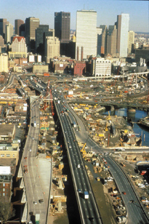
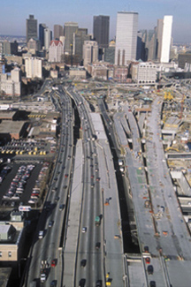
Dramatic changes in roadway configurations leading northeast toward Boston demonstrate
the complex construction required at the interchanges of interstate I-93, the
Massachusetts Turnpike (I-90) and the access ramps leading to the Third Harbor
Tunnel beneath the Fort Point Channel (just off the images to the right). The
image of the left reflects an approach to Boston before the Big Dig; on the
right, after. Image courtesy of CA/T Project and Bechtel/Parsons Brinckerhoff
Building the Big Dig means working in tight spaces that have low headroom and
are close to fragile, early 19th century masonry buildings. As construction
of Interstate I-93 below the city and I-90 access roads for the Ted Williams
Tunnel to Logan International Airport advances, workers are close to huge steel
and glass office towers and below-grade subway lines. Reportedly, former CA/T
Director Peter Zuk once likened the construction of the CA/T to “conducting
heart surgery on a patient actively playing tennis.” Several construction
approaches demonstrate the technical challenges the project teams face, as summarized
in an article prepared by the CA/T projeect for Southeast Asia Construction
magazine in January/February 2002:
- By far the biggest construction challenge is keeping the existing six-lane,
1959-vintage Central Artery operable, while construction occurs beneath it
and deep below ground, in some places to bedrock. Using permanent concrete
slurry walls typically supported in bedrock (and constructed by specialized
low-headroom equipment), the loads of the still-in-use highway structure are
shifted from their old supports to bear on the new slurry walls, which also
serve as lateral and vertical support walls for the new below-grade roadways.
Once the new roadway is complete, the aging Central Artery structure will
be demolished, and surface grades restored and landscaped.
- One applied construction technique in building the Ted Williams Tunnel used
sectional, immersed tube tunnels, lowered by barge into a prepared seabed
trench across Boston Harbor. A dozen twin-tube steel sections, each longer
than a football field, were sequentially connected and lowered, ribbon-like,
into the seabed floor. Each opening in the twin tubes is approximately 40
feet in diameter, and is dedicated to carry east bound or westbound traffic.
- Soil stabilization methods that allowed deep excavations to proceed while
reducing the possibility of lateral or vertical ground displacement included
ground freezing (with recirculating pipes containing superchilled brine);
jet grout underpinning (injecting cement-based or chemical grout into permeable
soils that later harden and strengthen the soil); and soil mixing (that incorporates
cement and the existing soils with a series of paddle-like mixers mounted
on a specialized drilling rig) which strengthens the soil overall.
- To extend I-90 (the Massachusetts Turnpike) beneath nine active railroad
tracks carrying Amtrak and MBTA Commuter Rail passenger trains from South
Station, designers employed three massive jacked tunnel boxes, essentially
pushing rectangular reinforced concrete sections into previously frozen soils.
After mining out and excavating soils at the working face with ‘road
header’ machinery, the tunnel box is pushed ahead several feet, and the
process repeated. This method avoided disruption of the railroad traffic that
would occur using the more conventional ‘cut-and-cover’ tunneling
method, and reduced the potential for construction-induced movement of the
rail alignments themselves.
Building on the past
The contributions of early local geologists, engineers and researchers laid
the groundwork for our current understanding of several problematic geologic
conditions that can exist throughout the Boston area. Many of these discoveries
and their subsequent engineering and construction solution were transferable
to similar conditions elsewhere. But even with our knowledge of historical conditions
and local construction experience, careful examination and analyses of site-specific
ground conditions are still performed for virtually all engineered structures,
including the tremendous Big Dig effort. As in the past, geologists and engineers
continue to gather more data and information about the subsurface. By applying
both well-established and advanced engineering construction techniques, they
learn to work with the existing “urban geology” beneath the city.
Urban
Fill: Everything Including the Kitchen Sink
Many Bostonians know that the city's shoreline footprint has grown through
history. The waterfront expanded outward into Boston Harbor and the city
grew onto land "reclaimed" along the Charles River estuary,
perhaps most famously in the Back Bay and South End areas. However, not
all of the residents give much thought to how much area actually was created,
and where the filling material originated. Nor do they consider how this
unique soil profile affects construction and underground engineering.
Cumulatively, an urban area far larger than the Back Bay was filled to
accommodate the growth and settlement patterns of the vibrant port and
commercial hub of Massachusetts. In their book Historical Atlas of
Massachusetts (1991), editors Richard Wilkie, Roy Doyon and Jack Tager
estimated that the general urban land area increased due to filling by
approximately 3,930 acres (6.1 square miles) between 1803 and 1988, very
roughly doubling Boston's geographic size. This estimate is qualified
somewhat, because it includes former towns later annexed by Boston (Charlestown,
Roxbury, East Boston, South Boston); portions of Cambridge and Brookline
adjacent to the Charles River; and Logan International Airport.
From an engineering and site characterization perspective, these urban
fills create problematic subsurface conditions that raise several yellow
flags to engineering geologists and geotechnical engineering professionals.
The soil properties of the fill materials and their engineering behavior,
particularly in response to surcharges, loads and excavations, are almost
exclusively unfavorable -- a situation that demands fairly comprehensive
evaluation and analysis prior to most excavation and construction activities.
Urban fills are likely to be heterogeneous over short distances, are compressible
due to their inconsistent manner of placement (or because they often contain
overly soft organic deposits), and are often unstable in proximity to
excavations. Because of their nature, these fills cannot be used as foundations
because due to the continued and variable settlement of the structure
that occurs, requiring support on deeper, more stable soils. In some areas
of Boston, fills have been documented to be more than 30 feet thick.
Creating particular problems for subsurface construction efforts are the
presence of former granite seawalls and wharves. These robust waterfront
structures, typically constructed from hundreds of massive, dry-laid granite
blocks and an underground "forest" of wood piles, were often
infilled with all manner of stone rubble, debris and a startling array
of other materials. Once buried and forgotten under an advancing urban
shoreline ("Progress!" the city's fathers must have shouted),
these structures lie in wait for the unsuspecting construction project.
The source of the fill soils is variable and identified in only limited
documentation. Several area drumlins, and the former topographic highs
on the original Shawmut Peninsula (including portions of Beacon Hill,
which was likely formed by localized ice thrusting and deformation of
earlier glacial tills, clays and sands during Pleistocene deglacial events),
were cut down and transported as borrow material to fill in low-lying
coves, bays and the developing waterfront. Land modification efforts were
so substantial that two of the original three major hills, or "trimounts"
(reflected in the name of Tremont Street), were completely removed and
leveled.
As described in Harl Aldrich's 1970 article in the journal of the Boston
Society of Civil Engineers, the Back Bay and Fenway areas were filled
between 1856 and 1890 using sand and gravel transported by train from
Needham, a residential community located about nine miles southwest of
Boston. Hydraulic fills were also used to provide material for certain
areas of Boston, where soft, organic marine muds and clays were dredged
to deepen channels or waterways, and then pumped or sluiced as slurry
to open coastal tracts rimmed by crude wooden barriers. Once exposed,
the hydraulic slurry desiccated, consolidated and provided the newest
"made land" along the waterfront.
Urban soils can also host a wide range of hazardous chemical contaminants
as well, often with no discrete or identifiable source. In a 360-year-old
city, a given parcel of land may have experienced uncountable building
and construction cycles, or several generations of undocumented commercial
or industrial uses. As byproducts of heating with wood, and later coal,
discarded cinders and ashes are common components of urban soils. Typical
fill contaminants may include polycyclic aromatic hydrocarbons (PAHs)
or other combustion byproducts, volatile organic compounds (VOCs) including
chlorinated solvents and lighter-fraction gasoline components, numerous
metals (from arsenic to zinc), and a slew of petroleum constituents. Contaminated
soil characterization and soil management is a significant cost consideration
for underground construction and development projects in an urban setting,
a cost exacerbated by the erratic subsurface extent, often high concentrations,
and variety of chemical compounds potentially present. To this end, one
environmental professional, tongue-firmly-in-cheek, succinctly described
the urban Boston soils as "Downtown Brown."
Bradford A. Miller
Back to top
|
Miller
is a senior environmental geologist at Haley & Aldrich Inc. in Boston, a company
that works on the Big Dig. He is also past president of the New England Section
of the Association of Engineering Geologists. E-mail
